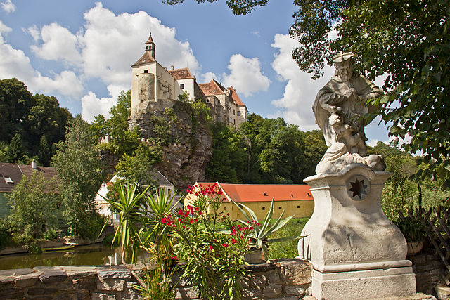
Лудвайс-Айген (Ludweis-Aigen, Ludweis-Aigen)
 Hiking in Лудвайс-Айген
Ludweis-Aigen, located in Austria, is a beautiful destination for hiking enthusiasts. Nestled in the rolling hills of the region, it offers picturesque landscapes, lush forests, and a variety of trails suited for all skill levels, from beginners to advanced hikers.
Trails and Scenery
-
Forest Trails: The area is rich in forested trails that vary in difficulty. These paths often lead through dense woodlands, where you can enjoy the serenity of nature and the sounds of wildlife.
-
Mountain Trails: For more experienced hikers, there are steeper mountain trails that offer breathtaking views of the surrounding valleys and peaks. Climbing to higher altitudes provides stunning vantage points, particularly at sunrise and sunset.
-
Cultural Paths: Some trails highlight cultural landmarks and historical sites in the area. You can discover traditional Austrian architecture and perhaps even local folklore tied to certain locations.
-
Flora and Fauna: The diverse ecosystems in Ludweis-Aigen host various plant and animal species. Keep an eye out for local wildlife, especially if you hike quietly!
Hints for Hiking in Ludweis-Aigen
- Check Weather Conditions: The weather can change rapidly in mountainous areas, so it's wise to check forecasts before setting out.
- Appropriate Gear: Wear sturdy hiking boots, dress in layers, and bring waterproof gear if necessary. Trekking poles can be helpful for steeper trails.
- Stay Hydrated and Nourished: Bring enough water and snacks to keep your energy up throughout the hike.
- Respect Nature: Follow the principles of Leave No Trace, ensuring that you respect the local environment and wildlife.
Local Resources
- Maps and Guides: Obtain detailed maps of the area from local tourist information centers or online resources. These can help identify the best trails for your hiking abilities.
- Guided Tours: If you're unfamiliar with the area, consider joining a guided hiking tour. Local guides can provide insights into the terrain, history, and flora and fauna you might encounter.
Overall, hiking in Ludweis-Aigen can be a rewarding experience, combining physical activity with the beauty of the Austrian countryside. Just be prepared, and you'll enjoy everything this stunning region has to offer!
- Страна:

- Почтовый код: 3762
- Телефонный код: 02847
- Код автомобильного номера: WT
- Координаты: 48° 46' 0" N, 15° 29' 0" E


- GPS треки (wikiloc): [Ссылка]
- Высота над уровнем моря: 507 м m
- Площадь: 51.18 кв.км
- Население: 914
- Веб сайт: http://www.ludweis-aigen.at/
- Википедия русская: wiki(ru)
- Википедия английская: wiki(en)
- Википедия национальная: wiki(de)
- Хранилище Wikidata: Wikidata: Q676151
- Катеория в википедии: [Ссылка]
- код Freebase: [/m/03gs7ns]
- код GeoNames: Альт: [7871921]
- код VIAF: Альт: [243210540]
- код австрийского муниципалитета: [32212]
Граничит с регионами:
Рабс-ан-дер-Тайя
- муниципалитет в Австрии
Hiking in Рабс-ан-дер-Тайя
Raabs an der Thaya is a picturesque town located in the Waldviertel region of Austria, near the borders with the Czech Republic. The area is known for its stunning natural landscapes, rich history, and outdoor recreational opportunities. Hiking in and around Raabs an der Thaya offers a mix of scenic trails, historical sites, and enchanting views of the Thaya River....
- Страна:
- Почтовый код: 3820
- Телефонный код: 02846
- Код автомобильного номера: WT
- Координаты: 48° 50' 53" N, 15° 29' 35" E
- GPS треки (wikiloc): [Ссылка]
- Высота над уровнем моря: 410 м m
- Площадь: 134.65 кв.км
- Население: 2651
- Веб сайт: [Ссылка]

Гросзигхартс
Hiking in Гросзигхартс
Groß-Siegharts, located in the Waldviertel region of Austria, offers a charming environment for hiking enthusiasts. This area is characterized by its rolling hills, dense forests, and picturesque landscapes, making it an appealing destination for both casual hikers and more experienced adventurers....
- Страна:
- Почтовый код: 3812
- Телефонный код: 02847
- Код автомобильного номера: WT
- Координаты: 48° 47' 0" N, 15° 24' 0" E
- GPS треки (wikiloc): [Ссылка]
- Высота над уровнем моря: 515 м m
- Площадь: 44.27 кв.км
- Население: 2775
- Веб сайт: [Ссылка]

Ирнфриц-Мессерн
Hiking in Ирнфриц-Мессерн
Irnfritz-Messern, located in Lower Austria, is a charming area known for its picturesque landscapes and scenic hiking trails. While it may not be as well-known as some of Austria's larger hiking destinations, it offers a peaceful retreat for nature lovers and hiking enthusiasts....
- Страна:
- Телефонный код: 02986
- Код автомобильного номера: HO
- Координаты: 48° 44' 23" N, 15° 33' 29" E
- GPS треки (wikiloc): [Ссылка]
- Высота над уровнем моря: 561 м m
- Площадь: 55.92 кв.км
- Население: 1409
- Веб сайт: [Ссылка]

Гёпфриц-ан-дер-Вильд
Hiking in Гёпфриц-ан-дер-Вильд
Göpfritz an der Wild, located in Lower Austria, is a charming destination for hiking enthusiasts who enjoy scenic landscapes and tranquil nature. The area offers a variety of trails that cater to different skill levels, making it suitable for both novice hikers and experienced trekkers....
- Страна:
- Почтовый код: 3800
- Телефонный код: 02825
- Код автомобильного номера: ZT
- Координаты: 48° 43' 0" N, 15° 24' 0" E
- GPS треки (wikiloc): [Ссылка]
- Высота над уровнем моря: 580 м m
- Площадь: 60.58 кв.км
- Население: 1856
- Веб сайт: [Ссылка]

Брун-ан-дер-Вильд
Hiking in Брун-ан-дер-Вильд
Brunn an der Wild is a quaint village located in the Austrian state of Lower Austria, nestled within the scenic Waldviertel region. The area is renowned for its lush landscapes, rolling hills, and dense forests, making it a fantastic destination for hiking enthusiasts....
- Страна:
- Почтовый код: 3595
- Телефонный код: 02989
- Код автомобильного номера: HO
- Координаты: 48° 41' 39" N, 15° 31' 10" E
- GPS треки (wikiloc): [Ссылка]
- Высота над уровнем моря: 442 м m
- Площадь: 32.03 кв.км
- Население: 826
- Веб сайт: [Ссылка]
Японс
Hiking in Японс
Hiking in Japan offers a diverse range of experiences, thanks to the country's varied landscapes, rich culture, and well-maintained trails. Here are some key points to consider when planning a hiking trip in Japan:...
- Страна:
- Почтовый код: 3763
- Телефонный код: 02914
- Код автомобильного номера: HO
- Координаты: 48° 47' 34" N, 15° 34' 5" E
- GPS треки (wikiloc): [Ссылка]
- Высота над уровнем моря: 525 м m
- Площадь: 29.38 кв.км
- Население: 733
- Веб сайт: [Ссылка]