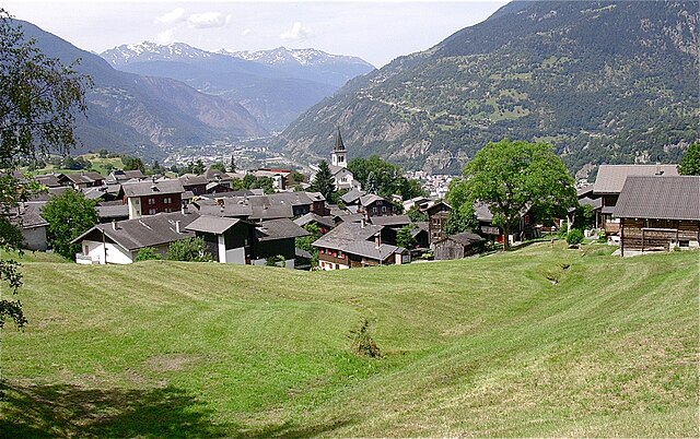
Mörel-Filet (Mörel-Filet)

 Hiking in Mörel-Filet
Mörel-Filet is a charming area located in the Valais region of Switzerland, nestled in the heart of the Alps. It offers a range of beautiful hiking trails, stunning landscapes, and opportunities for both novice and experienced hikers.
Hiking Trails
-
Mörel to Riederalp: This is a popular hike that allows you to appreciate the extensive alpine scenery. The trail is well-marked and provides stunning views of the surrounding mountains, including the mighty Matterhorn on clear days.
-
Aletsch Glacier Trail: A bit more challenging, this trail leads you to some of the best viewpoints of the Aletsch Glacier, a UNESCO World Heritage site. The trails can be varied in difficulty, so make sure to choose one that matches your skill level.
-
Filet to Bettmeralp: This trail offers a mix of forest paths and open mountain meadows. As you hike, you'll encounter traditional Swiss chalets and have plenty of opportunities for capturing breathtaking photographs.
Tips for Hiking in Mörel-Filet
-
Check the Weather: Conditions in the mountains can change rapidly. Always check the weather forecast before heading out.
-
Gear Up Appropriately: Wear good hiking boots and pack weather-appropriate clothing, as well as sufficient water and food.
-
Trail Etiquette: Stick to marked trails to protect the local flora and fauna, and be courteous to other hikers.
-
Visit Local Tourist Information: The local tourist office can provide updated information on trail conditions and recommendations based on your skill level.
-
Take Your Time: Don't rush your hike. Enjoy the scenery, take breaks, and if possible, try to spot local wildlife.
Whether you're looking for a leisurely walk or a more strenuous trek, Mörel-Filet has something to offer for every type of hiker. Enjoy your adventure in this beautiful Swiss region!
- Страна:

- Почтовый код: 3983
- Телефонный код: 027
- Код автомобильного номера: VS
- Координаты: 46° 21' 25" N, 8° 2' 53" E


- GPS треки (wikiloc): [Ссылка]
- Высота над уровнем моря: 746 м m
- Площадь: 8.4 кв.км
- Население: 678
- Веб сайт: http://www.moerel-filet.ch
- Википедия английская: wiki(en)
- Википедия национальная: wiki(de)
- Хранилище Wikidata: Wikidata: Q70643
- Катеория в википедии: [Ссылка]
- код Freebase: [/m/076yk33]
- код GeoNames: Альт: [7286552]
- ID отношения в OpenStreetMap: [1685343]
- идентификатор HDS: [49389]
- код швейцарского муниципалитета: [6203]
Граничит с регионами:
Termen
Hiking in Termen
Termen is a small municipality located in the southern region of Switzerland, known for its beautiful alpine landscapes. While it's not one of the most widely recognized hiking destinations compared to its neighbors, it does offer some excellent opportunities for hikers seeking tranquility and stunning views....
- Страна:
- Почтовый код: 3912
- Телефонный код: 027
- Код автомобильного номера: VS
- Координаты: 46° 19' 0" N, 8° 1' 0" E
- GPS треки (wikiloc): [Ссылка]
- Высота над уровнем моря: 925 м m
- Площадь: 18.8 кв.км
- Население: 913
- Веб сайт: [Ссылка]


Grengiols
Hiking in Grengiols
Grengiols is a charming village located in the Valais region of Switzerland, known for its stunning landscapes and diverse hiking opportunities. Nestled in the mountains, it offers a unique blend of natural beauty, traditional Swiss architecture, and a peaceful atmosphere. Here are some key points about hiking in Grengiols:...
- Страна:
- Почтовый код: 3993
- Телефонный код: 027
- Код автомобильного номера: VS
- Координаты: 46° 22' 0" N, 8° 6' 0" E
- GPS треки (wikiloc): [Ссылка]
- Высота над уровнем моря: 984 м m
- Площадь: 58.46 кв.км
- Население: 432
- Веб сайт: [Ссылка]


Riederalp
Hiking in Riederalp
Riederalp, located in the Swiss Alps in the Valais canton, is a fantastic destination for hikers of all skill levels. Nestled at an elevation of about 1,900 meters, it offers stunning views of the surrounding mountains, including the iconic Matterhorn and the Aletsch Glacier, which is the largest glacier in the Alps and a UNESCO World Heritage site....
- Страна:
- Почтовый код: 3987
- Телефонный код: 027
- Код автомобильного номера: VS
- Координаты: 46° 23' 0" N, 8° 2' 0" E
- GPS треки (wikiloc): [Ссылка]
- Высота над уровнем моря: 1905 м m
- Площадь: 21.04 кв.км
- Население: 481
- Веб сайт: [Ссылка]