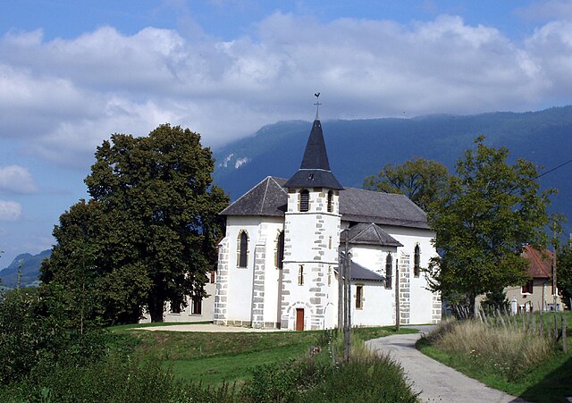
Marcieux (Marcieux)

- коммуна во Франции
 Hiking in Marcieux
Marcieux is a charming village located in the Savoie region of France, nestled near the beautiful lakes and mountains of the Rhône-Alpes. While it may not be as well-known as some larger hiking destinations, it offers various trails that cater to different skill levels and provide stunning views of the surrounding landscapes.
Hiking Trails in Marcieux
-
Le Mont du Chat: This trail leads to the summit of Mont du Chat, where you can enjoy panoramic views of Lake Bourget and the surrounding mountains. The hike is moderate in difficulty and takes around 2-3 hours to reach the top.
-
Lake Bourget Circuit: For a more leisurely hike, consider the trail that encircles Lake Bourget. This flat path is perfect for families and beginners, offering lovely views of the lake and opportunities for picnicking along the way.
-
Tour des Bauges: A longer hike that takes you through the Bauges Natural Regional Park, this circuit allows hikers to explore the diverse flora and fauna of the area. It's recommended for experienced hikers due to varying terrains and lengths.
Tips for Hiking in Marcieux
-
Check the Weather: Before embarking on your hike, it’s essential to check the weather conditions, as they can change rapidly in mountainous regions.
-
Proper Gear: Wear appropriate hiking boots and bring layers of clothing to adjust for temperature changes. Don't forget your water bottle and snacks!
-
Trail Maps: Obtain a trail map or download a hiking app to ensure you stay on the right path. Many trails are well marked, but it's always good to have a backup.
-
Respect Nature: Follow the Leave No Trace principles to preserve the natural beauty of the area. Stay on marked trails and avoid disturbing wildlife.
Nearby Attractions
While hiking is a highlight, Marcieux is also close to other attractions:
-
The Abbey of Hautecombe: An impressive abbey located on the shores of Lake Bourget offers a glimpse into the region's history and beautiful architecture.
-
Thermal Spas: After a day of hiking, consider relaxing in one of the thermal spas in nearby Aix-les-Bains.
Whether you’re a seasoned hiker or just looking for a peaceful walk in nature, Marcieux has something to offer. Enjoy your hiking adventure!
- Страна:

- Почтовый код: 73470
- Координаты: 45° 36' 47" N, 5° 45' 45" E


- GPS треки (wikiloc): [Ссылка]
- Площадь: 4.4 кв.км
- Население: 163
- Википедия английская: wiki(en)
- Википедия национальная: wiki(fr)
- Хранилище Wikidata: Wikidata: Q1217315
- Катеория в википедии: [Ссылка]
- код Freebase: [/m/03qlmmr]
- код GeoNames: Альт: [6442819]
- номер SIREN: [217301522]
- код BNF: [15274085t]
- код муниципалитета INSEE: 73152
Граничит с регионами:

Saint-Pierre-d'Alvey
- коммуна во Франции
Hiking in Saint-Pierre-d'Alvey
Saint-Pierre-d'Alvey is a picturesque commune located in the Savoie department in the Auvergne-Rhône-Alpes region of France. The area is characterized by its beautiful natural landscapes, making it a great destination for hiking enthusiasts....
- Страна:
- Почтовый код: 73170
- Координаты: 45° 37' 48" N, 5° 44' 33" E
- GPS треки (wikiloc): [Ссылка]
- Площадь: 7.7 кв.км
- Население: 273


Novalaise
- коммуна во Франции
Hiking in Novalaise
Novalaise is a charming commune located in the Savoie department of the Auvergne-Rhône-Alpes region in southeastern France. Nestled between the picturesque shores of Lake Aiguebelette and the surrounding mountains, it presents excellent opportunities for hiking enthusiasts....
- Страна:
- Почтовый код: 73470
- Координаты: 45° 35' 40" N, 5° 46' 18" E
- GPS треки (wikiloc): [Ссылка]
- Площадь: 16.26 кв.км
- Население: 2067


Nances
- коммуна во Франции
Hiking in Nances
Nances, often associated with scenic trails and beautiful landscapes, offers a variety of hiking opportunities for outdoor enthusiasts. Here’s a general guide to hiking in the Nances area, which you can adapt based on your specific location or preferences:...
- Страна:
- Почтовый код: 73470
- Координаты: 45° 35' 25" N, 5° 47' 48" E
- GPS треки (wikiloc): [Ссылка]
- Площадь: 9.9 кв.км
- Население: 451
- Веб сайт: [Ссылка]
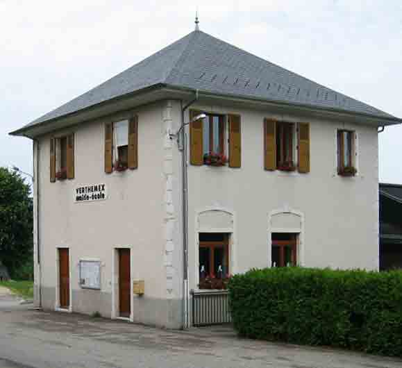

Verthemex
- коммуна во Франции
Hiking in Verthemex
Verthemex is not a widely recognized hiking destination, so it appears there might be a typo or misunderstanding regarding the location you mentioned. If you meant a specific area in a national park or a region known for hiking, please provide more context or clarify the name....
- Страна:
- Почтовый код: 73170
- Координаты: 45° 37' 46" N, 5° 47' 22" E
- GPS треки (wikiloc): [Ссылка]
- Площадь: 9.28 кв.км
- Население: 200


Meyrieux-Trouet
- коммуна во Франции
Hiking in Meyrieux-Trouet
Meyrieux-Trouet, located in the Savoie region of the French Alps, is a charming village that offers fantastic hiking opportunities amid stunning natural scenery. The area is characterized by its picturesque landscapes, including lush forests, mountain views, and beautiful valleys....
- Страна:
- Почтовый код: 73170
- Координаты: 45° 38' 36" N, 5° 46' 51" E
- GPS треки (wikiloc): [Ссылка]
- Площадь: 11.05 кв.км
- Население: 315


Gerbaix
- коммуна во Франции
Hiking in Gerbaix
Gerbaix is a picturesque region located in the French Alps, known for its stunning landscapes and a variety of hiking trails that cater to different skill levels. Here are some key points regarding hiking in Gerbaix:...
- Страна:
- Почтовый код: 73470
- Координаты: 45° 36' 35" N, 5° 44' 49" E
- GPS треки (wikiloc): [Ссылка]
- Площадь: 6.91 кв.км
- Население: 370

Ла Мот-Серволе
- коммуна во Франции
Hiking in Ла Мот-Серволе
La Motte-Servolex is a charming commune located in the Savoie department in the Auvergne-Rhône-Alpes region of southeastern France. Nestled near the foothills of the Chartreuse Mountains and close to the city of Chambéry, it offers a variety of hiking opportunities for all skill levels....
- Страна:
- Почтовый код: 73290
- Координаты: 45° 35' 48" N, 5° 52' 39" E
- GPS треки (wikiloc): [Ссылка]
- Площадь: 29.85 кв.км
- Население: 11731
- Веб сайт: [Ссылка]