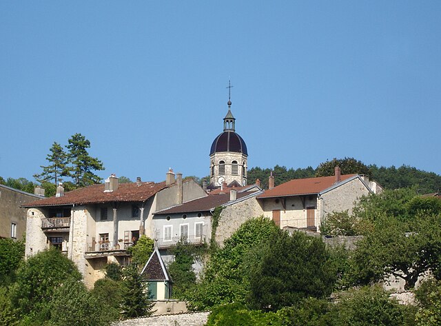
Мейонна (Meillonnas, Meillonnas)
- коммуна во Франции
 Hiking in Мейонна
Meillonnas is a picturesque village in the Ain department of the Auvergne-Rhône-Alpes region in France. The area is known for its natural beauty, charming countryside, and opportunities for outdoor activities, particularly hiking.
Hiking in Meillonnas:
-
Scenic Trails: The village is surrounded by beautiful landscapes, including rolling hills, forests, and fields. Hiking trails typically offer stunning views of the surrounding countryside and the nearby Jura Mountains.
-
Difficulty Levels: There are a variety of trails available ranging from easy walks suitable for families to more challenging hikes for those looking for a workout. You can find trails that span several kilometers, allowing hikers to tailor their experience according to their skill level and preference.
-
Wildlife and Flora: The region is rich in biodiversity, making it a great spot for nature lovers. You might encounter a variety of bird species, mammals, and a wide range of wildflowers along the trails.
-
Trail Markings: Many trails in the Meillonnas area are well-marked, making navigation easier for hikers. However, it’s always advisable to carry a map or use a GPS device to ensure you stay on track.
-
Accessibility: Meillonnas is conveniently located near larger towns, making it accessible for both locals and visitors. This proximity allows for easy day hikes or longer excursions.
-
Considerations: When hiking in the area, be sure to wear appropriate footwear, carry enough water, and check the weather conditions beforehand. Always inform someone about your hiking plans and estimated return time.
-
Local Knowledge: Engaging with local outdoor shops or hiking groups can provide you with additional insights about the best routes and any current trail conditions.
Conclusion
Hiking in Meillonnas can be a rewarding and enjoyable experience, offering a blend of natural beauty, peaceful surroundings, and varying levels of hiking challenges. Whether you are a casual walker or an experienced hiker, you’ll find something to enjoy in this lovely part of France.
- Страна:

- Почтовый код: 01370
- Координаты: 46° 14' 42" N, 5° 21' 7" E


- GPS треки (wikiloc): [Ссылка]
- Площадь: 17.74 кв.км
- Население: 1316
- Веб сайт: http://www.meillonnas.fr
- Википедия русская: wiki(ru)
- Википедия английская: wiki(en)
- Википедия национальная: wiki(fr)
- Хранилище Wikidata: Wikidata: Q782569
- Катеория в википедии: [Ссылка]
- Карты в википедии: [Ссылка]
- код Freebase: [/m/03czfwl]
- код Freebase: [/m/03czfwl]
- код GeoNames: Альт: [2994733]
- код GeoNames: Альт: [2994733]
- номер SIREN: [210102414]
- номер SIREN: [210102414]
- код BNF: [12285327h]
- код BNF: [12285327h]
- код VIAF: Альт: [135027706]
- код VIAF: Альт: [135027706]
- код LCNAF: Альт: [n95012660]
- код LCNAF: Альт: [n95012660]
- код тезауруса PACTOLS: [pcrt9lg29DZ2Ol]
- код тезауруса PACTOLS: [pcrt9lg29DZ2Ol]
- код муниципалитета INSEE: 01241
- код муниципалитета INSEE: 01241
Граничит с регионами:
Val-Revermont
Hiking in Val-Revermont
Val-Revermont is a picturesque region located in the foothills of the Jura Mountains in eastern France, offering an array of hiking opportunities for all skill levels. Known for its stunning landscapes, lush forests, rolling hills, and charming villages, Val-Revermont provides a beautiful setting for outdoor enthusiasts....
- Страна:
- Почтовый код: 01370
- Координаты: 46° 16' 20" N, 5° 22' 12" E
- GPS треки (wikiloc): [Ссылка]
- Площадь: 45.42 кв.км
- Веб сайт: [Ссылка]

Жасрон
- коммуна во Франции
Hiking in Жасрон
Jasseron, located in the Ain department of the Auvergne-Rhône-Alpes region in eastern France, offers beautiful landscapes for hiking enthusiasts. The area is characterized by rolling hills, lush greenery, and scenic views, making it an excellent destination for hikers of all levels....
- Страна:
- Почтовый код: 01250
- Координаты: 46° 12' 45" N, 5° 19' 28" E
- GPS треки (wikiloc): [Ссылка]
- Площадь: 18.93 кв.км
- Население: 1735
- Веб сайт: [Ссылка]
Треффор-Кюизья
- коммуна во Франции
Hiking in Треффор-Кюизья
Treffort-Cuisiat, located in the Ain department of the Auvergne-Rhône-Alpes region in southeastern France, is an area that offers diverse and beautiful hiking opportunities. The landscape here is characterized by rolling hills, forests, and picturesque views, making it a great spot for both leisurely walks and more challenging hikes....
- Страна:
- Почтовый код: 02220
- Координаты: 46° 16' 17" N, 5° 22' 6" E
- GPS треки (wikiloc): [Ссылка]
- Площадь: 39.41 кв.км
- Население: 1728
- Веб сайт: [Ссылка]

Дром
- коммуна во Франции
Hiking in Дром
Drom is a location in Ireland, known for its scenic beauty and diverse hiking opportunities. While it may not be as widely recognized as some of the more famous trails in the country, Drom and its surroundings offer a variety of hiking experiences suitable for different skill levels. Here are some highlights for hiking in the Drom area:...
- Страна:
- Почтовый код: 01250
- Координаты: 46° 13' 3" N, 5° 22' 7" E
- GPS треки (wikiloc): [Ссылка]
- Площадь: 7.78 кв.км
- Население: 219
- Веб сайт: [Ссылка]

Сент-Этьен-дю-Буа
- коммуна во Франции
Hiking in Сент-Этьен-дю-Буа
Saint-Étienne-du-Bois, located in the Ain department of the Auvergne-Rhône-Alpes region of France, offers a range of hiking opportunities for outdoor enthusiasts. The region is characterized by its picturesque landscapes, lush forests, and rolling hills, making it an inviting destination for both casual walkers and seasoned hikers....
- Страна:
- Почтовый код: 01370
- Координаты: 46° 17' 17" N, 5° 17' 36" E
- GPS треки (wikiloc): [Ссылка]
- Площадь: 28.38 кв.км
- Население: 2532
- Веб сайт: [Ссылка]