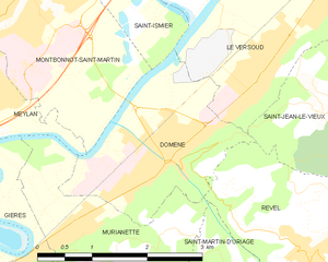
Монбонно-Сен-Мартен (Montbonnot-Saint-Martin, Montbonnot-Saint-Martin)

- коммуна во Франции
 Hiking in Монбонно-Сен-Мартен
Montbonnot-Saint-Martin is a charming commune located near Grenoble in the Auvergne-Rhône-Alpes region of France. It's situated at the foothills of the Chartreuse Mountains, making it an ideal starting point for hiking enthusiasts. Here’s what you can expect when hiking in and around Montbonnot-Saint-Martin:
Hiking Trails
-
Local Trails: There are several natural paths and trails that wind through the hills surrounding Montbonnot-Saint-Martin. These range from easy walks suitable for families to more challenging hikes that reward you with stunning views of the surrounding landscape.
-
Chartreuse Mountains: Just a short drive from Montbonnot-Saint-Martin, you can access the expansive network of trails in the Chartreuse Mountains. Popular hikes include the trails leading to the Grand Som and the Chamechaude, known for their breathtaking panoramas.
-
Belledonne Range: Another major hiking area accessible from Montbonnot-Saint-Martin is the Belledonne Range to the east, offering a more rugged terrain with alpine lakes, wildflower meadows, and unique rock formations.
Highlights
- Scenic Views: As you hike, you can enjoy picturesque landscapes, including views of the valley of Grenoble, the Isère River, and the surrounding mountain ranges.
- Flora and Fauna: The area is rich in biodiversity. Hikers might spot various plant species and wildlife, ranging from birds to small mammals.
- Historical Sites: Some trails may lead to interesting historical landmarks, such as old chapels or remnants of ancient dwellings, which add to the charm of your hiking experience.
Preparation
- Accessibility: The trails around Montbonnot-Saint-Martin are generally well-marked, but it's always wise to carry a map or a mobile GPS device.
- Equipment: Ensure you wear sturdy hiking boots, and carry water, snacks, and a first-aid kit. Depending on the season, consider weather-appropriate gear.
- Local Regulations: Be aware of any local regulations regarding hiking, especially in natural reserves, to help preserve the environment.
Best Times to Hike
- Spring and Fall: These seasons offer pleasant weather, where temperatures are moderate and the scenery is often vibrant with blooming flowers or fall foliage.
- Summer: Great for long hikes, but be prepared for warmer temperatures and potentially crowded trails.
- Winter: While hiking can be limited due to snow, some trails can offer winter walking opportunities, especially for those equipped for snow hiking.
Overall, Montbonnot-Saint-Martin serves as an excellent base for exploring the hiking opportunities in the beautiful French Alps, providing both beginners and seasoned hikers with a variety of trails to experience the natural beauty of the region.
- Страна:

- Почтовый код: 38330
- Координаты: 45° 13' 37" N, 5° 48' 9" E


- GPS треки (wikiloc): [Ссылка]
- Площадь: 6.38 кв.км
- Население: 5010
- Веб сайт: http://www.montbonnot.fr
- Википедия русская: wiki(ru)
- Википедия английская: wiki(en)
- Википедия национальная: wiki(fr)
- Хранилище Wikidata: Wikidata: Q1068817
- Катеория в википедии: [Ссылка]
- код Freebase: [/m/03nvgkl]
- код GeoNames: Альт: [6433251]
- номер SIREN: [213802499]
- код BNF: [15258061c]
- код VIAF: Альт: [156030916]
- код LCNAF: Альт: [n87134491]
- код тезауруса PACTOLS: [pcrtU02bRqvyEr]
- код SUDOC: [067100503]
- код муниципалитета INSEE: 38249
Граничит с регионами:

Домен
- коммуна во Франции
Hiking in Домен
Domène, located in the Isère department in the Auvergne-Rhône-Alpes region of southeastern France, offers picturesque hiking opportunities with stunning views of the surrounding mountains and valleys. Nestled near the Chartreuse and Belledonne mountain ranges, the area boasts a variety of trails suitable for different skill levels, from leisurely walks to more challenging hikes....
- Страна:
- Почтовый код: 38420
- Координаты: 45° 12' 9" N, 5° 50' 20" E
- GPS треки (wikiloc): [Ссылка]
- Площадь: 5.29 кв.км
- Население: 6739
- Веб сайт: [Ссылка]


Сент-Исмье
- коммуна во Франции
Hiking in Сент-Исмье
Saint-Ismier is a charming village located in the Auvergne-Rhône-Alpes region of southeastern France, near the Isère River and the picturesque city of Grenoble. The surrounding area offers a variety of hiking options, making it an excellent destination for both novice and experienced hikers. Here are some key points to consider if you're planning to hike in and around Saint-Ismier:...
- Страна:
- Почтовый код: 38330
- Координаты: 45° 14' 55" N, 5° 49' 37" E
- GPS треки (wikiloc): [Ссылка]
- Площадь: 14.9 кв.км
- Население: 6857
- Веб сайт: [Ссылка]

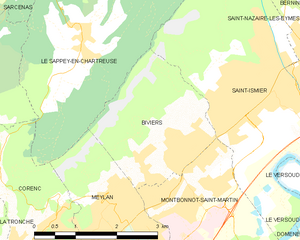
Бивье
- коммуна во Франции
Hiking in Бивье
Biviers is a small town located near Grenoble in the Auvergne-Rhône-Alpes region of France, and it serves as a great gateway for exploring the beautiful surrounding landscapes. Hiking in and around Biviers offers various opportunities for outdoor enthusiasts, ranging from easy walks to more challenging trails....
- Страна:
- Почтовый код: 38330
- Координаты: 45° 14' 24" N, 5° 48' 12" E
- GPS треки (wikiloc): [Ссылка]
- Площадь: 6.17 кв.км
- Население: 2324


Мелан
Hiking in Мелан
Meylan is a charming suburb located near Grenoble in the Auvergne-Rhône-Alpes region of France. It is surrounded by beautiful natural landscapes, making it a great starting point for hiking enthusiasts. Here are some things to know about hiking in and around Meylan:...
- Страна:
- Почтовый код: 38240
- Координаты: 45° 12' 31" N, 5° 46' 46" E
- GPS треки (wikiloc): [Ссылка]
- Площадь: 12.32 кв.км
- Население: 17289
- Веб сайт: [Ссылка]