Мюрьянетт (Murianette, Murianette)

- коммуна во Франции
 Hiking in Мюрьянетт
Murianette is a beautiful area located in the region of Piedmont, Italy, near the city of Turin. It offers a variety of hiking trails that showcase stunning landscapes, lush greenery, and a rich diversity of flora and fauna. Here are a few key points about hiking in the Murianette area:
Trail Options
- Scenic Routes: There are several well-marked trails in the area that cater to various skill levels, from easy walks suitable for families to challenging hikes for experienced trekkers.
- Natural Beauty: Hikers can enjoy picturesque views of the surrounding hills, valleys, and, depending on the time of year, a variety of wildflowers.
Best Time to Hike
- Spring and Fall: The best times to hike in Murianette are during the spring and fall when the weather is mild, and the scenery is particularly beautiful.
- Summer: Summer can be quite warm, so early morning or late afternoon hikes are recommended to avoid the heat.
- Winter: Some trails may be accessible for winter hiking or snowshoeing, depending on the snowfall.
Preparation
- Gear: Make sure to wear sturdy hiking boots and bring plenty of water, snacks, and a map or GPS device to navigate the trails.
- Local Wildlife: Be aware of local wildlife and practice standard safety precautions, especially when hiking in more remote areas.
Additional Activities
- Photography: The area provides fantastic opportunities for photography, so don’t forget your camera!
- Flora and Fauna: Look out for local wildlife and plant species; a hiking guidebook can help you identify them.
Access and Transportation
- Directions: Murianette is accessible by car or public transport from Turin. Make sure to check local transport schedules if you’re relying on public transit.
Always check the latest weather conditions and trail status before heading out, as conditions can change quickly in the mountains. Happy hiking!
- Страна:

- Почтовый код: 38420
- Координаты: 45° 11' 30" N, 5° 49' 13" E


- GPS треки (wikiloc): [Ссылка]
- Площадь: 6.07 кв.км
- Население: 886
- Веб сайт: http://www.murianette.fr
- Википедия русская: wiki(ru)
- Википедия английская: wiki(en)
- Википедия национальная: wiki(fr)
- Хранилище Wikidata: Wikidata: Q691120
- Катеория в википедии: [Ссылка]
- код Freebase: [/m/03g_56s]
- код GeoNames: Альт: [6433261]
- номер SIREN: [213802713]
- код BNF: [15258083p]
- код Trismegistos: [21659]
- код муниципалитета INSEE: 38271
Граничит с регионами:

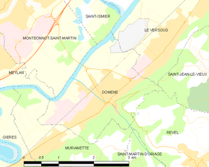
Домен
- коммуна во Франции
Hiking in Домен
Domène, located in the Isère department in the Auvergne-Rhône-Alpes region of southeastern France, offers picturesque hiking opportunities with stunning views of the surrounding mountains and valleys. Nestled near the Chartreuse and Belledonne mountain ranges, the area boasts a variety of trails suitable for different skill levels, from leisurely walks to more challenging hikes....
- Страна:
- Почтовый код: 38420
- Координаты: 45° 12' 9" N, 5° 50' 20" E
- GPS треки (wikiloc): [Ссылка]
- Площадь: 5.29 кв.км
- Население: 6739
- Веб сайт: [Ссылка]


Ревель
Hiking in Ревель
Revel, located in the Isère department of the Auvergne-Rhône-Alpes region in southeastern France, is a fantastic destination for hiking enthusiasts. The area is characterized by its stunning alpine scenery, diverse landscapes, and a variety of trails suitable for different skill levels. Here are some highlights and tips for hiking in Revel:...
- Страна:
- Почтовый код: 38420
- Координаты: 45° 11' 9" N, 5° 52' 5" E
- GPS треки (wikiloc): [Ссылка]
- Площадь: 29.55 кв.км
- Население: 1340
- Веб сайт: [Ссылка]


Венон
- коммуна во Франции
Hiking in Венон
Venon, located in the Isère department of the Auvergne-Rhône-Alpes region in France, is a beautiful area for hiking, offering stunning landscapes and various trails to explore. The scenery showcases the natural beauty of the French Alps, with opportunities to see mountains, valleys, and lush greenery....
- Страна:
- Почтовый код: 38610
- Координаты: 45° 10' 19" N, 5° 48' 16" E
- GPS треки (wikiloc): [Ссылка]
- Площадь: 4.34 кв.км
- Население: 723
- Веб сайт: [Ссылка]


Сен-Мартен-д'Ирьяж
- коммуна во Франции
Hiking in Сен-Мартен-д'Ирьяж
Saint-Martin-d'Uriage is a charming commune located in the Isère department of southeastern France. Nestled at the foothills of the Belledonne mountain range, it offers a variety of hiking opportunities that cater to different skill levels and preferences....
- Страна:
- Почтовый код: 38410
- Координаты: 45° 9' 8" N, 5° 50' 21" E
- GPS треки (wikiloc): [Ссылка]
- Площадь: 29.69 кв.км
- Население: 5408
- Веб сайт: [Ссылка]

Жьер
- коммуна во Франции
Hiking in Жьер
Gières is a charming village located in the Auvergne-Rhône-Alpes region of France, near the city of Grenoble. It boasts a scenic backdrop of the surrounding mountains, making it a wonderful place for hiking enthusiasts. Here are some key points to consider if you're planning to hike in or around Gières:...
- Страна:
- Почтовый код: 38610
- Координаты: 45° 10' 55" N, 5° 47' 31" E
- GPS треки (wikiloc): [Ссылка]
- Площадь: 6.93 кв.км
- Население: 6483
- Веб сайт: [Ссылка]


Мелан
Hiking in Мелан
Meylan is a charming suburb located near Grenoble in the Auvergne-Rhône-Alpes region of France. It is surrounded by beautiful natural landscapes, making it a great starting point for hiking enthusiasts. Here are some things to know about hiking in and around Meylan:...
- Страна:
- Почтовый код: 38240
- Координаты: 45° 12' 31" N, 5° 46' 46" E
- GPS треки (wikiloc): [Ссылка]
- Площадь: 12.32 кв.км
- Население: 17289
- Веб сайт: [Ссылка]