Peillonnex (Peillonnex)

- коммуна во Франции
 Hiking in Peillonnex
Peillonnex, located in the Auvergne-Rhône-Alpes region of France, offers beautiful hiking opportunities with stunning views of the surrounding mountains and countryside. Here are some key points to consider when hiking in this area:
Trails and Routes
- Varied Terrain: The region features various trails that cater to different skill levels, from easy walks suitable for families to more challenging hikes for seasoned adventurers.
- Scenic Views: Many trails offer panoramic views of Lake Geneva and the surrounding mountains, making for picturesque hiking experiences.
- Natural Parks: Nearby nature reserves and parks provide additional hiking routes, often with informative signs about the local flora and fauna.
Preparation
- Map and Compass: It's a good idea to have a map of the area or a GPS-enabled device, as some trails may not be well-marked.
- Weather Considerations: Always check the weather forecast prior to setting out. The weather can change rapidly in mountainous regions.
- Proper Gear: Wear sturdy hiking boots and bring plenty of water, snacks, and sun protection, especially during warmer months.
Local Attractions
- Historic Sites: In addition to hiking, you can explore local heritage sites in Peillonnex and surrounding areas, adding a cultural aspect to your visit.
- Wildlife Watching: Keep an eye out for local wildlife, as the area is home to various species that can often be spotted along the trails.
Safety Tips
- Inform Someone: Let someone know your planned route and expected return time.
- Stay on Trails: To preserve the natural landscape and for your safety, stick to marked trails.
- Buddy System: If possible, hike with a friend or a group for added safety.
Best Time to Hike
- Spring and Fall: These seasons often provide the most pleasant temperatures and beautiful scenery with blooming flowers or autumn foliage.
- Summer: Hiking is popular, but be prepared for potential heat and higher foot traffic on popular trails.
Overall, Peillonnex is a great destination for hiking enthusiasts looking to explore the natural beauty of the French Alps while enjoying the charm of a small village. If you’re in the area, take the time to enjoy the various trails and the breathtaking landscapes they offer!
- Страна:

- Почтовый код: 74250
- Координаты: 46° 7' 53" N, 6° 22' 34" E


- GPS треки (wikiloc): [Ссылка]
- Площадь: 6.4 кв.км
- Население: 1390
- Веб сайт: http://www.peillonnex.fr
- Википедия английская: wiki(en)
- Википедия национальная: wiki(fr)
- Хранилище Wikidata: Wikidata: Q845842
- Катеория в википедии: [Ссылка]
- код Freebase: [/m/03ntzzw]
- код GeoNames: Альт: [6443020]
- номер SIREN: [217402098]
- код BNF: [15274466n]
- код VIAF: Альт: [245869968]
- WOEID: [12668081]
- код муниципалитета INSEE: 74209
Граничит с регионами:

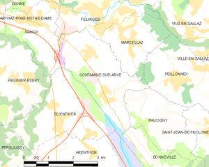
Contamine-sur-Arve
- коммуна во Франции
Hiking in Contamine-sur-Arve
Contamine-sur-Arve is a charming commune located in the Haute-Savoie region of France, near Mont Blanc. It offers a variety of hiking opportunities that cater to different skill levels and preferences. Here are some highlights and tips for hiking in and around Contamine-sur-Arve:...
- Страна:
- Почтовый код: 74130
- Координаты: 46° 7' 42" N, 6° 20' 26" E
- GPS треки (wikiloc): [Ссылка]
- Площадь: 6.92 кв.км
- Население: 1940
- Веб сайт: [Ссылка]


Viuz-en-Sallaz
- коммуна во Франции
Hiking in Viuz-en-Sallaz
Viuz-en-Sallaz, located in the Haute-Savoie region of France, is an ideal destination for hiking enthusiasts. Nestled in the foothills of the Alps, it offers a mix of scenic landscapes, including lush forests, rolling hills, and panoramic mountain views....
- Страна:
- Почтовый код: 74250
- Координаты: 46° 8' 51" N, 6° 24' 37" E
- GPS треки (wikiloc): [Ссылка]
- Площадь: 20.99 кв.км
- Население: 4206


La Tour
Hiking in La Tour
La Tour, located in the Haute-Savoie region of the French Alps, offers some beautiful hiking opportunities, catering to a range of skill levels from beginners to experienced hikers. Here’s an overview of what you can expect when hiking in this picturesque area:...
- Страна:
- Почтовый код: 74250
- Координаты: 46° 7' 58" N, 6° 25' 50" E
- GPS треки (wikiloc): [Ссылка]
- Площадь: 7.73 кв.км
- Население: 1248


Marcellaz
- коммуна во Франции
Hiking in Marcellaz
Marcellaz is a picturesque area located in the Haute-Savoie region of France, surrounded by the stunning French Alps. It offers a variety of hiking trails that cater to different experience levels, making it a great destination for both novice and experienced hikers....
- Страна:
- Почтовый код: 74250
- Координаты: 46° 8' 40" N, 6° 21' 16" E
- GPS треки (wikiloc): [Ссылка]
- Площадь: 4.17 кв.км
- Население: 967


Ville-en-Sallaz
- коммуна во Франции
Hiking in Ville-en-Sallaz
Ville-en-Sallaz is a picturesque village located in the Haute-Savoie region of southeastern France, surrounded by stunning Alpine scenery, making it an excellent starting point for various hiking adventures. Here are some highlights and tips for hiking in and around Ville-en-Sallaz:...
- Страна:
- Почтовый код: 74250
- Координаты: 46° 8' 45" N, 6° 25' 20" E
- GPS треки (wikiloc): [Ссылка]
- Площадь: 3.37 кв.км
- Население: 871


Faucigny
- коммуна во Франции
Hiking in Faucigny
Faucigny is a beautiful region located in the Haute-Savoie department in the Auvergne-Rhône-Alpes region of southeastern France. The area is known for its stunning landscapes, characterized by the French Alps, lush valleys, and charming villages. Here are some highlights and tips for hiking in Faucigny:...
- Страна:
- Почтовый код: 74130
- Координаты: 46° 7' 7" N, 6° 21' 28" E
- GPS треки (wikiloc): [Ссылка]
- Площадь: 4.91 кв.км
- Население: 593


Saint-Jean-de-Tholome
- коммуна во Франции
Hiking in Saint-Jean-de-Tholome
Saint-Jean-de-Tholome is a charming village located in the Haute-Savoie region of France, which is part of the Auvergne-Rhône-Alpes. This area is blessed with stunning natural landscapes that are perfect for hiking enthusiasts....
- Страна:
- Почтовый код: 74250
- Координаты: 46° 6' 42" N, 6° 23' 52" E
- GPS треки (wikiloc): [Ссылка]
- Площадь: 12.37 кв.км
- Население: 947