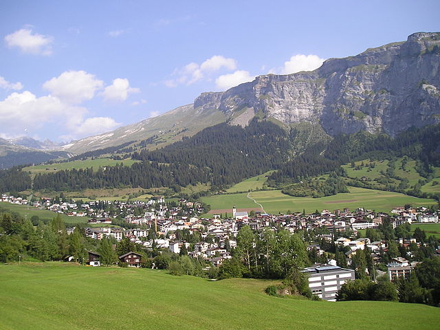
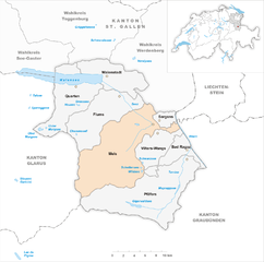
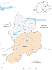
Пфеферс (Pfäfers, Pfäfers)

 Hiking in Пфеферс
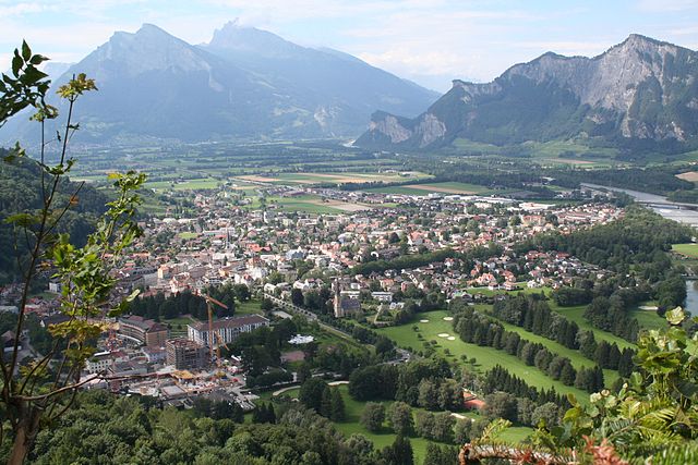
Pfäfers, located in the canton of St. Gallen in Switzerland, is a stunning destination for hiking enthusiasts. The region is renowned for its dramatic landscapes, featuring the picturesque Rhine Gorge, often referred to as the "Grand Canyon of Switzerland." Here are some highlights and tips for hiking in Pfäfers:
Trails and Scenery
-
Rhine Gorge Trail: This well-known trail offers breathtaking views and unique geological formations. The hike typically starts in the village of Ilanz and follows the Rhine River, allowing you to witness the stunning gorge and its surroundings.
-
Pfäfers Waterfalls: A short hike will lead you to the charming Pfäfers Waterfalls. The sound of cascading water and the lush greenery make it a picturesque spot for a break or a picnic.
-
Thermal Springs: While not a hike in itself, the area around Pfäfers features natural thermal springs. You can enjoy a relaxing soak after a day of hiking, particularly in the nearby town of Bad Ragaz.
-
Alpine Trails: Pfäfers is also a gateway to higher alpine trails. If you're up for a challenge, consider climbing toward the peaks that overlook the valley, offering panoramic views of the surrounding Alps.
Difficulty Levels
Hiking trails in the Pfäfers area can range from easy family-friendly walks to more strenuous mountain hikes. Always assess your fitness level and choose trails that match it.
Weather and Safety
- Weather Conditions: Be aware that mountain weather can change rapidly. Always check weather forecasts before you head out and be prepared for rain or sudden temperature drops.
- Safety Tips: Ensure you have the proper hiking gear, including sturdy footwear, sufficient water, and snacks. It's also a good idea to carry a map or a GPS device, especially on less-marked trails.
Best Times to Hike
- Summer (June to September): Ideal for beautiful weather and clear trails. The Alpine flowers will be in full bloom, adding to the scenery.
- Autumn (October): Offers stunning fall colors, but be aware that the weather can become unpredictable.
Local Amenities
- Accommodation: Pfäfers has options for accommodation, ranging from hotels to guesthouses. You can also find eateries serving local cuisine.
- Transportation: Public transport is accessible, with connections to nearby cities like Chur and St. Gallen, making it easy to reach the area.
Conclusion
Hiking in Pfäfers is a truly enriching experience, offering a blend of natural beauty and serene landscapes. Whether you’re a novice or an experienced hiker, you’ll find plenty of options to explore and enjoy the great outdoors in this charming Swiss region. Always remember to leave no trace and respect nature during your adventures. Happy hiking!
- Страна:

- Почтовый код: 7312
- Телефонный код: 081
- Код автомобильного номера: SG
- Координаты: 46° 58' 59" N, 9° 29' 59" E


- GPS треки (wikiloc): [Ссылка]
- Высота над уровнем моря: 820 м m
- Площадь: 128.53 кв.км
- Население: 1574
- Веб сайт: http://www.pfaefers.ch
- Википедия русская: wiki(ru)
- Википедия английская: wiki(en)
- Википедия национальная: wiki(de)
- Хранилище Wikidata: Wikidata: Q66052
- Катеория в википедии: [Ссылка]
- код Freebase: [/m/07yxty]
- код GeoNames: Альт: [2659224]
- код VIAF: Альт: [234662193]
- ID отношения в OpenStreetMap: [1683919]
- идентификатор HDS: [1355]
- код швейцарского муниципалитета: [3294]
Граничит с регионами:


Таминс
Hiking in Таминс
Tamins, a picturesque village located in the Graubünden region of Switzerland, offers a wonderful setting for hiking enthusiasts. Nestled in the Rhine Valley, surrounded by stunning mountain landscapes, it provides various trails suitable for different skill levels....
- Страна:
- Почтовый код: 7015
- Телефонный код: 081
- Код автомобильного номера: GR
- Координаты: 46° 49' 46" N, 9° 24' 24" E
- GPS треки (wikiloc): [Ссылка]
- Высота над уровнем моря: 1430 м m
- Площадь: 40.74 кв.км
- Население: 1213
- Веб сайт: [Ссылка]


Фельсберг
Hiking in Фельсберг
Felsberg, located in the canton of Graubünden in Switzerland, offers a variety of hiking experiences amidst stunning natural beauty. With its picturesque landscapes, including mountains, valleys, and rivers, Felsberg serves as a great base for both novice and experienced hikers....
- Страна:
- Почтовый код: 7012
- Телефонный код: 081
- Код автомобильного номера: GR
- Координаты: 46° 49' 59" N, 9° 27' 59" E
- GPS треки (wikiloc): [Ссылка]
- Высота над уровнем моря: 572 м m
- Площадь: 13.40 кв.км
- Население: 2569
- Веб сайт: [Ссылка]

Флимс
Hiking in Флимс
Flims, located in the Swiss canton of Graubünden, is a fantastic destination for hiking enthusiasts. This picturesque region offers stunning scenery, including impressive rock formations, forests, alpine meadows, and beautiful lakes. Here are some highlights and essential information for hiking in Flims:...
- Страна:
- Почтовый код: 7017
- Телефонный код: 081
- Код автомобильного номера: GR
- Координаты: 46° 49' 59" N, 9° 16' 59" E
- GPS треки (wikiloc): [Ссылка]
- Высота над уровнем моря: 1848 м m
- Площадь: 50.46 кв.км
- Население: 2825
- Веб сайт: [Ссылка]

Трин
Hiking in Трин
Hiking in Trin, a small village in the canton of Graubünden in Switzerland, offers stunning opportunities for outdoor enthusiasts. Known for its breathtaking landscapes, Trin serves as a great base for a variety of hiking trails that cater to different skill levels....
- Страна:
- Почтовый код: 7014
- Телефонный код: 081
- Код автомобильного номера: GR
- Координаты: 46° 51' 45" N, 9° 19' 48" E
- GPS треки (wikiloc): [Ссылка]
- Высота над уровнем моря: 1851 м m
- Площадь: 47.17 кв.км
- Население: 1408
- Веб сайт: [Ссылка]


Хальденштайн
Hiking in Хальденштайн
Haldenstein, located in the canton of Graubünden in Switzerland, is an excellent destination for hiking enthusiasts. The area is known for its stunning landscapes, picturesque views, and a variety of hiking trails that cater to different skill levels....
- Страна:
- Почтовый код: 7023
- Телефонный код: 081
- Код автомобильного номера: GR
- Координаты: 46° 52' 43" N, 9° 31' 37" E
- GPS треки (wikiloc): [Ссылка]
- Высота над уровнем моря: 1557 м m
- Площадь: 18.56 кв.км
- Население: 1025
- Веб сайт: [Ссылка]

Мельс
Hiking in Мельс
Mels is a picturesque village located in the canton of St. Gallen in Switzerland, surrounded by beautiful landscapes and accessible hiking trails. The area offers a variety of hiking routes suitable for different skill levels, from leisurely strolls to more challenging treks. Here are some highlights for hiking in Mels:...
- Страна:
- Почтовый код: 8887
- Телефонный код: 081
- Код автомобильного номера: SG
- Координаты: 47° 2' 59" N, 9° 25' 0" E
- GPS треки (wikiloc): [Ссылка]
- Высота над уровнем моря: 1579 м m
- Площадь: 140.00 кв.км
- Население: 8610
- Веб сайт: [Ссылка]

Унтервац
Hiking in Унтервац
Untervaz is a picturesque village located in the Canton of Graubünden in Switzerland, known for its stunning landscapes, lush nature, and diverse hiking trails. Here are some key points about hiking in Untervaz:...
- Страна:
- Почтовый код: 7204
- Телефонный код: 081
- Код автомобильного номера: GR
- Координаты: 46° 55' 14" N, 9° 30' 57" E
- GPS треки (wikiloc): [Ссылка]
- Высота над уровнем моря: 1145 м m
- Площадь: 27.72 кв.км
- Население: 2512
- Веб сайт: [Ссылка]

Glarus Süd
Hiking in Glarus Süd
Glarus Süd, located in the canton of Glarus in Switzerland, is a fantastic destination for hiking enthusiasts. This region boasts stunning landscapes, ranging from lush valleys to rugged mountain terrains. Here are some key points about hiking in Glarus Süd:...
- Страна:
- Почтовый код: 8756, 8762, 8765, 8766, 8767, 8772, 8773, 8774, 8775, 8777, 8782, 8783, 8784
- Телефонный код: 055
- Код автомобильного номера: GL
- Координаты: 46° 59' 40" N, 9° 4' 27" E
- GPS треки (wikiloc): [Ссылка]
- Высота над уровнем моря: 521 м m
- Площадь: 430.2 кв.км
- Население: 9581
- Веб сайт: [Ссылка]

Бад-Рагац
Hiking in Бад-Рагац
Bad Ragaz, located in the Swiss Rhine Valley near the foothills of the Alps, is a fantastic destination for hiking enthusiasts. Known for its thermal baths and wellness resorts, the area also offers beautiful landscapes and a variety of hiking trails suitable for different skill levels. Here are some highlights for hiking in Bad Ragaz:...
- Страна:
- Почтовый код: 7310
- Телефонный код: 081
- Код автомобильного номера: SG
- Координаты: 46° 59' 59" N, 9° 30' 0" E
- GPS треки (wikiloc): [Ссылка]
- Высота над уровнем моря: 516 м m
- Площадь: 25.37 кв.км
- Население: 5923
- Веб сайт: [Ссылка]