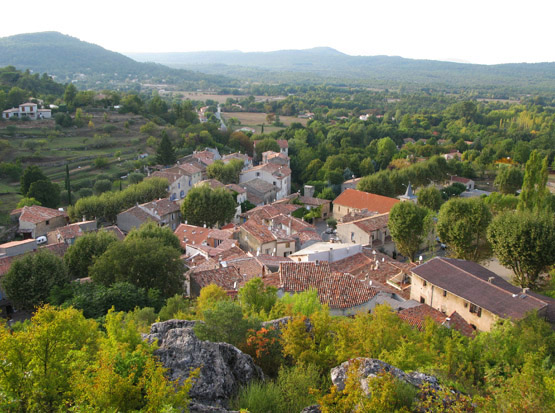
План-д’Опс-Сент-Бом (Plan-d'Aups-Sainte-Baume, Plan-d'Aups-Sainte-Baume)

- коммуна во Франции
 Hiking in План-д’Опс-Сент-Бом
Plan-d'Aups-Sainte-Baume is a beautiful destination for hiking enthusiasts, located in the Var department of the Provence-Alpes-Côte d'Azur region of southeastern France. Nestled at the foot of the Sainte-Baume mountain range, this area offers a range of trails that vary in difficulty and scenery.
Key Features:
-
Natural Beauty: The region is known for its stunning landscapes, dense forests, limestone cliffs, and rich biodiversity. The Sainte-Baume mountain range is characterized by its dramatic cliffs, verdant valleys, and panoramic views.
-
Trails: There are several hiking trails in and around Plan-d'Aups-Sainte-Baume, suitable for different skill levels. Some popular routes include:
- GR9 Trail: This long-distance trail traverses through the natural park and offers a mix of challenging terrains and breathtaking views.
- The Circuit of Sainte-Baume: This circular hike provides insights into the region's history and an opportunity to explore the lush forests.
-
Cultural Highlights: While hiking, you can discover the historical sites, such as the Monastery of Sainte-Marie-Madeleine, which is a significant pilgrimage site.
-
Wildlife: The area is home to diverse flora and fauna, making it a fantastic destination for nature lovers and wildlife watchers. Keep an eye out for various bird species and endemic plants.
-
Best Time to Hike: The best time for hiking in this region is during the spring (April to June) and fall (September to October) when the weather is mild, and the trails are less crowded.
-
Preparation: Ensure you're equipped with proper hiking gear, including sturdy boots, water, snacks, and a map or GPS device. Some trails can be steep and rocky, so being physically prepared is essential.
-
Guided Tours: If you prefer a more structured experience, consider joining guided hikes offered by local companies, which can provide valuable insights into the natural history and geography of the area.
Before heading out, it's always a good idea to check local conditions and trail updates, as weather can change rapidly in mountainous areas. Happy hiking!
- Страна:

- Почтовый код: 83640
- Координаты: 43° 19' 48" N, 5° 43' 3" E


- GPS треки (wikiloc): [Ссылка]
- Высота над уровнем моря: 700 м m
- Площадь: 24.91 кв.км
- Население: 2067
- Википедия русская: wiki(ru)
- Википедия английская: wiki(en)
- Википедия национальная: wiki(fr)
- Хранилище Wikidata: Wikidata: Q1363937
- Катеория в википедии: [Ссылка]
- код Freebase: [/m/03x_wq_]
- код GeoNames: Альт: [6617826]
- номер SIREN: [218300937]
- идентификатор местоположения ArchINFORM: [5389]
- код тезауруса PACTOLS: [pcrtUvBksg13vl]
- код муниципалитета INSEE: 83093
Граничит с регионами:

Мазог
- коммуна во Франции
Hiking in Мазог
Mazaugues is a charming village located in the Var department of the Provence-Alpes-Côte d'Azur region in southeastern France. It is surrounded by beautiful landscapes, making it a great destination for hiking enthusiasts. Here are some highlights about hiking in and around Mazaugues:...
- Страна:
- Почтовый код: 83136
- Координаты: 43° 20' 51" N, 5° 55' 19" E
- GPS треки (wikiloc): [Ссылка]
- Площадь: 53.79 кв.км
- Население: 887


Жемнос
- коммуна во Франции
- Страна:
- Почтовый код: 13420
- Координаты: 43° 17' 46" N, 5° 37' 37" E
- GPS треки (wikiloc): [Ссылка]
- Площадь: 32.75 кв.км
- Население: 6387
- Веб сайт: [Ссылка]

Орьоль
- коммуна в департаменте Буш-дю-Рон (Франция)
Hiking in Орьоль
Auriol, located in the Bouches-du-Rhône department in the Provence-Alpes-Côte d'Azur region of southern France, offers a variety of scenic hiking opportunities. Nestled between the Sainte-Baume mountains and the Calanques National Park, Auriol provides a beautiful backdrop with diverse landscapes, from hills and forests to rugged cliffs and Mediterranean flora....
- Страна:
- Почтовый код: 13390
- Координаты: 43° 22' 10" N, 5° 37' 53" E
- GPS треки (wikiloc): [Ссылка]
- Площадь: 44.64 кв.км
- Население: 11538
- Веб сайт: [Ссылка]


Кюж-ле-Пен
- коммуна во Франции
- Страна:
- Почтовый код: 13780
- Координаты: 43° 16' 35" N, 5° 42' 2" E
- GPS треки (wikiloc): [Ссылка]
- Площадь: 38.81 кв.км
- Население: 5007
- Веб сайт: [Ссылка]


Нан-ле-Пен
- коммуна во Франции
Hiking in Нан-ле-Пен
Nans-les-Pins is a charming village located in the Var department in the Provence-Alpes-Côte d'Azur region of France. It's surrounded by beautiful landscapes, making it a great destination for hiking enthusiasts. Here are some highlights of hiking in and around Nans-les-Pins:...
- Страна:
- Почтовый код: 83860
- Координаты: 43° 22' 14" N, 5° 46' 56" E
- GPS треки (wikiloc): [Ссылка]
- Площадь: 47.99 кв.км
- Население: 4276
- Веб сайт: [Ссылка]


Синь
- коммуна департамента Вар,Франция
Hiking in Синь
Signes is a charming village located in the Var department of the Provence-Alpes-Côte d'Azur region in southeastern France. It offers a variety of hiking opportunities, showcasing the region's stunning natural landscapes, rich flora, and diverse fauna....
- Страна:
- Почтовый код: 83870
- Координаты: 43° 17' 29" N, 5° 51' 46" E
- GPS треки (wikiloc): [Ссылка]
- Площадь: 133.1 кв.км
- Население: 2779


Рибу
- коммуна во Франции
Hiking in Рибу
Riboux is a picturesque area located in the Provence-Alpes-Côte d'Azur region of France, known for its stunning natural landscapes and diverse hiking trails. Here are some key points to consider when hiking in Riboux:...
- Страна:
- Почтовый код: 13780
- Координаты: 43° 18' 12" N, 5° 45' 23" E
- GPS треки (wikiloc): [Ссылка]
- Площадь: 13.48 кв.км
- Население: 42


Сен-Зашари
- коммуна во Франции
Hiking in Сен-Зашари
Saint-Zacharie is a charming commune located in the Provence-Alpes-Côte d'Azur region of France, nestled in the foothills of the Sainte-Baume mountain range. The area offers a range of hiking opportunities that cater to various skill levels and preferences, making it an excellent destination for outdoor enthusiasts....
- Страна:
- Почтовый код: 83640
- Координаты: 43° 23' 3" N, 5° 42' 24" E
- GPS треки (wikiloc): [Ссылка]
- Площадь: 27.02 кв.км
- Население: 5392