Поншарра (Pontcharra, Pontcharra)

- коммуна во Франции
 Hiking in Поншарра
Pontcharra is a charming town located in the Auvergne-Rhône-Alpes region of France, nestled in the Isère department. It offers great opportunities for hiking, surrounded by beautiful natural landscapes, including the Chartreuse and Belledonne mountain ranges. Here’s an overview of what you can expect when hiking in and around Pontcharra:
Trails and Paths
-
Local Trails: There are several well-marked trails in and around Pontcharra, ranging from easy strolls to more challenging hikes. Many trails provide stunning views of the surrounding mountains and valleys.
-
Chartreuse Mountains: This nearby mountain range offers a variety of hikes with different levels of difficulty. Trails can vary from scenic walks through forests to challenging ascents with breathtaking panoramas.
-
Belledonne Mountains: To the east of Pontcharra, the Belledonne range is home to higher peaks and more challenging hikes. These trails are perfect for hikers looking for adventure with a mix of spectacular alpine scenery.
Seasonal Considerations
-
Spring and Summer: The best time for hiking in this region is typically from spring to early fall when the weather is milder and the trails are more accessible. Wildflowers bloom, and the lush landscapes are ideal for exploring.
-
Fall: Autumn offers beautiful foliage and cooler temperatures, making it a wonderful time for hiking, though be prepared for possible rain.
-
Winter: If you're experienced in winter hiking, you can still enjoy the trails, particularly those suited for snowshoeing or cross-country skiing in the higher areas.
Tips for Hiking in Pontcharra
-
Prepare for Weather Changes: Mountain weather can be unpredictable. Dress in layers and carry rain gear.
-
Adequate Footwear: Wear sturdy hiking boots to navigate the various terrains comfortably.
-
Hydration and Nutrition: Bring enough water and snacks to keep your energy up during hikes, especially on longer trails.
-
Local Maps and Guides: Consider obtaining local hiking maps or joining guided hikes to discover the best trails and stay safe.
-
Respect Nature: Follow Leave No Trace principles to ensure the area's beauty is preserved for future visitors.
Nearby Attractions
Aside from hiking, Pontcharra has a charming town center and is close to other tourist attractions such as lakes, waterfalls, and historical sites that can be explored while enjoying the outdoors.
In summary, Pontcharra and its surroundings provide a wealth of hiking opportunities for all levels. Whether you’re a casual walker or an experienced hiker, you'll find trails that suit your level of expertise while enjoying the stunning beauty of the French Alps.
- Страна:

- Почтовый код: 38530
- Координаты: 45° 25' 59" N, 6° 0' 55" E


- GPS треки (wikiloc): [Ссылка]
- Площадь: 15.58 кв.км
- Население: 7258
- Веб сайт: http://www.ville-pontcharra.fr
- Википедия русская: wiki(ru)
- Википедия английская: wiki(en)
- Википедия национальная: wiki(fr)
- Хранилище Wikidata: Wikidata: Q472184
- Катеория в википедии: [Ссылка]
- код Freebase: [/m/03g_60x]
- код Freebase: [/m/03g_60x]
- код GeoNames: Альт: [2986275]
- код GeoNames: Альт: [2986275]
- номер SIREN: [213803141]
- номер SIREN: [213803141]
- код BNF: [152581264]
- код BNF: [152581264]
- код VIAF: Альт: [146207398]
- код VIAF: Альт: [146207398]
- код GND: Альт: [4760239-9]
- код GND: Альт: [4760239-9]
- код LCNAF: Альт: [nr91045259]
- код LCNAF: Альт: [nr91045259]
- код муниципалитета INSEE: 38314
- код муниципалитета INSEE: 38314
Граничит с регионами:

Ле-Шелас
- коммуна во Франции
Hiking in Ле-Шелас
Le Cheylas, located in the French Alps near the Isère River, is an excellent destination for hiking enthusiasts. The area offers stunning landscapes, picturesque valleys, and a variety of trails suitable for different skill levels. Here are some highlights you might consider if you're planning a hike in Le Cheylas:...
- Страна:
- Почтовый код: 38570
- Координаты: 45° 22' 17" N, 5° 59' 33" E
- GPS треки (wikiloc): [Ссылка]
- Площадь: 8.44 кв.км
- Население: 2612
- Веб сайт: [Ссылка]

Шапареян
- коммуна во Франции
Hiking in Шапареян
Chapareillan is a charming commune located in the Auvergne-Rhône-Alpes region of France, known for its stunning natural landscapes and outdoor activities, including hiking. The area offers a variety of hiking trails suitable for different skill levels, making it a great destination for both beginners and experienced hikers....
- Страна:
- Почтовый код: 38530
- Координаты: 45° 27' 46" N, 5° 59' 28" E
- GPS треки (wikiloc): [Ссылка]
- Площадь: 30.28 кв.км
- Население: 2950
- Веб сайт: [Ссылка]

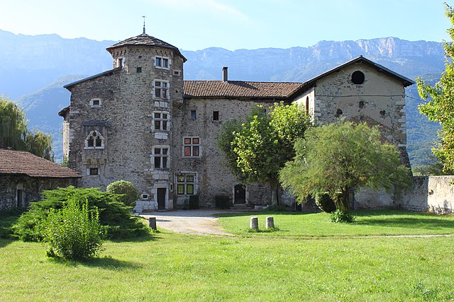
Сен-Максимен
Hiking in Сен-Максимен
Saint-Maximin, located in the Isère department in the Auvergne-Rhône-Alpes region of France, offers a range of beautiful hiking opportunities. Surrounded by the picturesque landscape of the Vercors and Chartreuse mountain ranges, it provides hikers with stunning views, diverse terrain, and a variety of trails suitable for different skill levels....
- Страна:
- Почтовый код: 38530
- Координаты: 45° 25' 35" N, 6° 2' 16" E
- GPS треки (wikiloc): [Ссылка]
- Площадь: 10.35 кв.км
- Население: 643
- Веб сайт: [Ссылка]


Барро
Hiking in Барро
Barraux, a charming village located near Grenoble in the Isère department of France, offers several hiking opportunities that are suitable for different skill levels. The area is characterized by its beautiful natural scenery, including the nearby Chartreuse Mountains, which provide a stunning backdrop for outdoor activities....
- Страна:
- Почтовый код: 38530
- Координаты: 45° 26' 4" N, 5° 58' 40" E
- GPS треки (wikiloc): [Ссылка]
- Площадь: 11.13 кв.км
- Население: 1876
- Веб сайт: [Ссылка]


Аллевар
- коммуна во Франции
Hiking in Аллевар
Allevard is a charming town located in the Auvergne-Rhône-Alpes region of France, nestled in the Belledonne mountain range. It's an excellent destination for hikers due to its diverse landscapes, ranging from forests and rivers to rocky peaks....
- Страна:
- Почтовый код: 38580
- Координаты: 45° 23' 37" N, 6° 4' 27" E
- GPS треки (wikiloc): [Ссылка]
- Площадь: 25.63 кв.км
- Население: 4124
- Веб сайт: [Ссылка]

Ла-Бюисьер
- коммуна во Франции
Hiking in Ла-Бюисьер
La Buissière is a charming village located in France, often characterized by its scenic landscapes and proximity to nature, making it an excellent location for hiking enthusiasts. While the specific trails in La Buissière may not be widely documented, the surrounding regions typically offer various outdoor activities, including hiking paths that range from easy strolls to more challenging treks....
- Страна:
- Почтовый код: 38530
- Координаты: 45° 24' 9" N, 5° 58' 42" E
- GPS треки (wikiloc): [Ссылка]
- Площадь: 7.71 кв.км
- Население: 672
- Веб сайт: [Ссылка]


Laissaud
- коммуна во Франции
Hiking in Laissaud
Laissaud is a beautiful area located in the French Alps, known for its stunning scenery and diverse hiking opportunities. The region offers a variety of trails suitable for different skill levels, from gentle walks to more challenging treks. Here's some information to help you plan your hiking experience in Laissaud:...
- Страна:
- Почтовый код: 73800
- Координаты: 45° 26' 49" N, 6° 2' 13" E
- GPS треки (wikiloc): [Ссылка]
- Площадь: 6.57 кв.км
- Население: 660