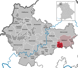
Поппенхаузен (Poppenhausen, Poppenhausen)

 Hiking in Поппенхаузен
Poppenhausen, located in the picturesque Rhön region of Germany, offers a variety of hiking opportunities for both beginners and experienced hikers alike. This charming village is an ideal starting point for exploring the stunning landscapes, diverse ecosystems, and unique geological formations that the Rhön has to offer.
Key Highlights for Hiking in Poppenhausen:
-
Scenic Trails: The area features numerous well-marked hiking trails that showcase the natural beauty of the environment. Popular routes include the Rhön High Trail and paths leading to the surrounding hills, such as the Wasserkuppe, which is the highest mountain in the Rhön.
-
Diverse Landscapes: Hikers can experience a variety of terrains, from lush forests and rolling hills to open pastures and panoramic views from higher elevations. The region is known for its unique basalt rock formations and protected moorland areas.
-
Nature Reserves: The nearby UNESCO Biosphere Reserve Rhön is a highlight, featuring various flora and fauna endemic to the region. Birdwatching and wildlife spotting can be enjoyable aspects of your hike.
-
Cultural Points of Interest: Along the hiking trails, you may come across traditional Rhön houses, historical landmarks, and local farms. The region is also known for its rich cultural heritage, including local gastronomy.
-
Seasonal Hiking: Each season offers a different hiking experience. Spring and summer are great for wildflowers and greenery, while fall presents beautiful autumn colors. Winter hiking can provide a magical landscape, especially if the area is covered in snow.
-
Hiking Facilities: Poppenhausen has various amenities for hikers, including guesthouses and eateries offering local cuisine. Maps and resources for the trails can usually be found in local tourist centers or online.
-
Safety and Preparations: As with any hiking adventure, it's important to prepare adequately. Ensure you're wearing appropriate hiking gear, carry sufficient water and snacks, and check the weather conditions before setting out.
Recommended Hikes:
- Wasserkuppe Route: A hike that takes you to the summit of the Wasserkuppe, providing breathtaking views and a sense of accomplishment.
- Moor Nature Trail: A relatively easy path that leads through picturesque moor landscapes, perfect for those who want to immerse themselves in nature without strenuous exertion.
Hiking in Poppenhausen and the surrounding Rhön is a fulfilling experience that allows you to connect with nature while enjoying the tranquility and beauty of this unique region. Be sure to respect local guidelines, and always leave no trace to preserve the environment for future hikers!
- Страна:

- Почтовый код: 97490
- Телефонный код: 09725
- Код автомобильного номера: SW
- Координаты: 50° 6' 0" N, 10° 9' 0" E


- GPS треки (wikiloc): [Ссылка]
- Высота над уровнем моря: 250 м m
- Площадь: 39.13 кв.км
- Население: 3682
- Веб сайт: https://www.poppenhausen.de/
- Википедия русская: wiki(ru)
- Википедия английская: wiki(en)
- Википедия национальная: wiki(de)
- Хранилище Wikidata: Wikidata: Q558671
- Катеория в википедии: [Ссылка]
- код Freebase: [/m/02q8g7z]
- код GeoNames: Альт: [6557065]
- код VIAF: Альт: [238732255]
- ID отношения в OpenStreetMap: [325551]
- код GND: Альт: [4116048-4]
- Bavarikon ID: [ODB_A00000479]
- идентификатор муниципалитетов в Германии: 09678168
Граничит с регионами:


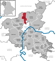
Эрленбах
- муниципалитет в Германии, Бавария
Hiking in Эрленбах
Oerlenbach, located in Bavaria, Germany, offers a range of hiking opportunities that allow enthusiasts to enjoy the beautiful natural landscapes of the region. Here are some highlights to consider for hiking in and around Oerlenbach:...
- Страна:
- Почтовый код: 97714
- Телефонный код: 09738; 09725
- Код автомобильного номера: KG
- Координаты: 50° 8' 59" N, 10° 7' 59" E
- GPS треки (wikiloc): [Ссылка]
- Высота над уровнем моря: 304 м m
- Площадь: 33.41 кв.км
- Население: 4660
- Веб сайт: [Ссылка]

Раннунген
Hiking in Раннунген
Rannungen is a small and scenic area in Germany, typically characterized by its natural landscapes and local trails. While it might not be as widely known as some of the larger hiking destinations, it offers a chance to explore beautiful surroundings in a quieter setting....
- Страна:
- Почтовый код: 97517
- Телефонный код: 09738
- Код автомобильного номера: KG
- Координаты: 50° 10' 0" N, 10° 12' 19" E
- GPS треки (wikiloc): [Ссылка]
- Высота над уровнем моря: 352 м m
- Площадь: 17.34 кв.км
- Население: 1117
- Веб сайт: [Ссылка]


Зульцталь
Hiking in Зульцталь
Sulzthal, located in Germany, provides a tranquil setting for hiking enthusiasts, with its picturesque landscapes, rolling hills, and scenic trails. While there's not an extensive range of well-known hiking routes specifically labeled under Sulzthal, its proximity to regional trails and natural attractions makes it an excellent base for exploring the surrounding areas....
- Страна:
- Почтовый код: 97717
- Телефонный код: 09704
- Код автомобильного номера: KG
- Координаты: 50° 8' 0" N, 10° 2' 0" E
- GPS треки (wikiloc): [Ссылка]
- Высота над уровнем моря: 254 м m
- Площадь: 15.06 кв.км
- Население: 859
- Веб сайт: [Ссылка]


Рамсталь
Hiking in Рамсталь
Ramsthal is a small village located in the Bavaria region of Germany, known for its scenic countryside and beautiful landscapes. While it may not be as famous as some larger hiking destinations, it offers a tranquil setting suitable for outdoor activities such as hiking....
- Страна:
- Почтовый код: 97729
- Телефонный код: 09704
- Код автомобильного номера: KG
- Координаты: 50° 8' 0" N, 10° 4' 0" E
- GPS треки (wikiloc): [Ссылка]
- Высота над уровнем моря: 252 м m
- Площадь: 10.42 кв.км
- Население: 1105
- Веб сайт: [Ссылка]

Диттельбрунн
Hiking in Диттельбрунн
Dittelbrunn is a charming municipality located in Bavaria, Germany, near the larger city of Schweinfurt. The surrounding area boasts beautiful landscapes and nature, making it a great destination for hiking enthusiasts....
- Страна:
- Почтовый код: 97456
- Телефонный код: 09738; 09725; 09721
- Код автомобильного номера: SW
- Координаты: 50° 5' 42" N, 10° 12' 34" E
- GPS треки (wikiloc): [Ссылка]
- Высота над уровнем моря: 237 м m
- Площадь: 23.84 кв.км
- Население: 6838
- Веб сайт: [Ссылка]


Ойербах
Hiking in Ойербах
Euerbach, located in the picturesque region of Bavaria, Germany, is a great destination for hiking enthusiasts. The area offers a range of trails that cater to various skill levels, from leisurely strolls to more challenging hikes. Here are some key points about hiking in Euerbach:...
- Страна:
- Почтовый код: 97502
- Телефонный код: 09726
- Код автомобильного номера: SW
- Координаты: 50° 4' 0" N, 10° 7' 0" E
- GPS треки (wikiloc): [Ссылка]
- Высота над уровнем моря: 238 м m
- Площадь: 17.40 кв.км
- Население: 2627
- Веб сайт: [Ссылка]


Нидерверн
Hiking in Нидерверн
Niederwerrn is a small village in Bavaria, Germany, and while it may not be as well-known for hiking as larger national parks or mountainous regions, it offers some charming opportunities for outdoor enthusiasts. The surrounding countryside features scenic rural landscapes, fields, and wooded areas that can provide a variety of trails for walking and hiking....
- Страна:
- Почтовый код: 97464
- Телефонный код: 09721
- Код автомобильного номера: SW
- Координаты: 50° 4' 0" N, 10° 10' 59" E
- GPS треки (wikiloc): [Ссылка]
- Высота над уровнем моря: 240 м m
- Площадь: 9.77 кв.км
- Население: 6146
- Веб сайт: [Ссылка]