Пре-Сен-Дидье (Pré-Saint-Didier, Pré-Saint-Didier)
.svg)
- коммуна Италии
 Hiking in Пре-Сен-Дидье
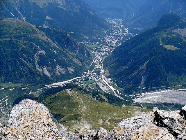
Pré-Saint-Didier, located in the Aosta Valley region of Italy, is a picturesque destination for hiking enthusiasts. Nestled in the foothills of the Mont Blanc massif, it offers breathtaking views, challenging trails, and a range of outdoor activities suitable for all levels of hikers.
Popular Hiking Trails
-
Trail to La Thuile: This moderate trail takes you from Pré-Saint-Didier to La Thuile, providing magnificent views of the surrounding mountains and valleys. The trail is well-marked and can be completed in approximately 3-4 hours.
-
The Chemin de la Vigne: A scenic path that leads you through vineyards and charming villages. This easy to moderate trail is perfect for families and those looking to enjoy a leisurely hike with beautiful landscapes.
-
The Mont de la Saxe Loop: A more challenging hike, this loop trail offers stunning panoramic views of Mont Blanc and surrounding peaks. Expect a full day’s hike with varied terrain, ideal for experienced hikers.
-
Val Ferret: Located nearby, this valley features several hiking options ranging from easy walks to more challenging routes. The trails are well-marked, and the area is known for its wildflowers and alpine scenery.
Important Considerations
-
Weather: Weather conditions can change rapidly in the mountains. Always check forecasts and be prepared for varying conditions, especially in higher altitudes.
-
Equipment: Proper hiking gear is essential. Good hiking boots, clothing suitable for the weather, and a backpack with water, snacks, a map/GPS, a first-aid kit, and a whistle are recommended.
-
Local Regulations: Always follow local guidelines and regulations regarding wildlife and natural resources. Staying on marked trails helps preserve the environment.
-
Guided Tours: If you're new to hiking or want to explore more remote areas, consider joining a guided tour. Local guides can provide valuable insights into the area's flora, fauna, and history.
Access and Amenities
Pré-Saint-Didier is easily accessible from major towns in the Aosta Valley, such as Courmayeur and Aosta itself. You’ll find various accommodations, restaurants, and shops in the village catering to hikers' needs.
Whether you're searching for a leisurely walk or an adventurous trek, Pré-Saint-Didier provides an excellent base for your outdoor exploration. Be sure to enjoy the stunning alpine scenery and the charm of the local culture as you hike.
- Страна:

- Почтовый код: 11010
- Телефонный код: 0165
- Код автомобильного номера: AO
- Координаты: 45° 45' 51" N, 6° 59' 9" E


- GPS треки (wikiloc): [Ссылка]
- Высота над уровнем моря: 1004 м m
- Площадь: 33.4 кв.км
- Население: 1025
- Веб сайт: http://www.comune.pre-saint-didier.ao.it
- Википедия русская: wiki(ru)
- Википедия английская: wiki(en)
- Википедия национальная: wiki(it)
- Хранилище Wikidata: Wikidata: Q35295
- Галерея изображений в википедии: [Ссылка]
- Катеория в википедии: [Ссылка]
- Карты в википедии: [Ссылка]
- код Freebase: [/m/0fwz5f]
- код GeoNames: Альт: [6535963]
- код VIAF: Альт: [240085728]
- ID отношения в OpenStreetMap: [46032]
- код Цифрового атласа Римской империи: [11057]
- код ISTAT: 007053
- кадастровый код Италии: H042
Граничит с регионами:

Курмайёр
- коммуна Италии
Hiking in Курмайёр
Courmayeur, located in the Aosta Valley of Italy, is a fantastic destination for hikers. Nestled at the foot of Mont Blanc, the area offers a variety of trails that cater to all skill levels, from leisurely walks to challenging alpine hikes. Here are some highlights for hiking in Courmayeur:...
- Страна:
- Почтовый код: 11013
- Телефонный код: 0165
- Код автомобильного номера: AO
- Координаты: 45° 47' 0" N, 6° 58' 0" E
- GPS треки (wikiloc): [Ссылка]
- Высота над уровнем моря: 1224 м m
- Площадь: 210 кв.км
- Население: 2798
- Веб сайт: [Ссылка]


Ла-Тюйль
- коммуна Италии
Hiking in Ла-Тюйль
La Thuile, located in the Aosta Valley region of Italy, is a fantastic destination for hiking enthusiasts. Nestled in the Alps, this area offers stunning landscapes, diverse wildlife, and a variety of hiking trails suitable for all skill levels, from beginners to experienced adventurers....
- Страна:
- Почтовый код: 11016
- Телефонный код: 0165
- Код автомобильного номера: AO
- Координаты: 45° 42' 58" N, 6° 57' 0" E
- GPS треки (wikiloc): [Ссылка]
- Высота над уровнем моря: 1450 м m
- Площадь: 125.67 кв.км
- Население: 783
- Веб сайт: [Ссылка]


Морже
- коммуна Италии
Hiking in Морже
Morgex, located in the Aosta Valley region of Italy, is a beautiful destination for hiking enthusiasts. Nestled in the Italian Alps, it offers stunning landscapes, rich wildlife, and a variety of trails suited for different skill levels. Here are some highlights and tips for hiking in and around Morgex:...
- Страна:
- Почтовый код: 11017
- Телефонный код: 0165
- Код автомобильного номера: AO
- Координаты: 45° 45' 0" N, 7° 2' 0" E
- GPS треки (wikiloc): [Ссылка]
- Высота над уровнем моря: 923 м m
- Площадь: 43.63 кв.км
- Население: 2123
- Веб сайт: [Ссылка]