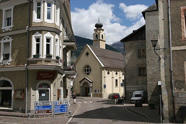
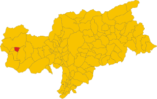
Прато-алло-Стельвио (Prad am Stilfser Joch, Prato allo Stelvio)
.svg)
- коммуна в Италии
 Hiking in Прато-алло-Стельвио
Prad am Stilfser Joch is a charming village located in the South Tyrol region of Italy, nestled at the entrance to the Stilfser Joch National Park. This area is renowned for its stunning natural landscapes, mountainous terrain, and excellent hiking opportunities. Here are some highlights and tips for hiking in this region:
Hiking Trails
-
Stilfser Joch National Park:
- The park offers a variety of trails suited for all levels of hikers, ranging from easy walks to more challenging treks. The scenery includes dramatic mountain peaks, lush meadows, and clear alpine lakes.
- Popular starting points in Prad provide access to the park’s extensive trail network.
-
Sentiero dei fiori:
- This is a beautiful hike that takes you through meadows filled with wildflowers during the summer months. The trail also offers panoramic views of the surrounding mountains.
-
Trekking to the Forte Pozzo:
- A moderately difficult hike that takes you to historical military fortifications with excellent views of the valley. It's a great way to combine history with nature.
-
The Bormio and Stelvio Pass Trails:
- Hikes around these renowned passes offer exhilarating views and a chance to experience the unique flora and fauna of the high alpine environment.
Tips for Hiking in Prad am Stilfser Joch
-
Best Time to Visit: Late spring to early autumn (roughly May to October) is ideal for hiking due to favorable weather conditions and opened trails.
-
Preparation: Check local weather conditions before heading out, as mountain weather can change rapidly. Prepare for varying conditions by dressing in layers and packing waterproof gear.
-
Trail Maps: Obtain a local map or download digital trail guides to navigate the paths easily. Signs are generally well-marked, but a map can help you keep track of your route.
-
Safety: Always inform someone about your hiking plan, especially if going on longer or more remote trails. Carry enough water, snacks, and a first-aid kit.
-
Leave No Trace: Respect the natural environment by adhering to the principles of Leave No Trace. Stay on marked trails and pack out all your trash.
-
Local Guidance: Consider joining guided hikes or tours offered by local organizations to gain insight from experienced guides who know the trails intimately and can enhance your experience.
Hiking in Prad am Stilfser Joch offers a memorable experience with breathtaking views and a chance to connect with nature in one of the most beautiful areas of the Italian Alps. Enjoy your adventure!
- Страна:

- Почтовый код: 39026
- Телефонный код: 0473
- Код автомобильного номера: BZ
- Координаты: 46° 37' 8" N, 10° 35' 29" E


- GPS треки (wikiloc): [Ссылка]
- Высота над уровнем моря: 3375 м m
- Площадь: 51.49 кв.км
- Население: 3474
- Веб сайт: http://www.comune.prato.bz.it
- Википедия русская: wiki(ru)
- Википедия английская: wiki(en)
- Википедия национальная: wiki(it)
- Хранилище Wikidata: Wikidata: Q474174
- Галерея изображений в википедии: [Ссылка]
- Катеория в википедии: [Ссылка]
- код Freebase: [/m/0g9j1c]
- код GeoNames: Альт: [6535921]
- код VIAF: Альт: [235218774]
- ID отношения в OpenStreetMap: [47280]
- код GND: Альт: [4528031-9]
- код ISTAT: 021067
- кадастровый код Италии: H004
Граничит с регионами:

Глоренца
- коммуна Италии
Hiking in Глоренца
Glurns (or Glorenza) is a small historical town located in the South Tyrol region of northern Italy. It's nestled in the Venosta Valley and is known for its charming medieval architecture, stunning mountain scenery, and a rich cultural heritage....
- Страна:
- Почтовый код: 39020
- Телефонный код: 0473
- Код автомобильного номера: BZ
- Координаты: 46° 40' 16" N, 10° 33' 25" E
- GPS треки (wikiloc): [Ссылка]
- Высота над уровнем моря: 907 м m
- Площадь: 13.22 кв.км
- Население: 897
- Веб сайт: [Ссылка]


Лаза
- коммуна Италии
Hiking in Лаза
Laas, located in the stunning South Tyrol region of northern Italy, is a small village known for its beautiful landscapes and excellent hiking opportunities. Nestled in the heart of the Alps, Laas boasts a mix of gentle trails and more challenging routes, making it suitable for hikers of all levels....
- Страна:
- Почтовый код: 39023
- Телефонный код: 0473
- Код автомобильного номера: BZ
- Координаты: 46° 37' 4" N, 10° 41' 52" E
- GPS треки (wikiloc): [Ссылка]
- Высота над уровнем моря: 868 м m
- Площадь: 110.23 кв.км
- Население: 4028
- Веб сайт: [Ссылка]

Слудерно
- коммуна в Италии
Hiking in Слудерно
Schluderns, located in South Tyrol, Italy, is a charming village surrounded by stunning landscapes and offers a variety of hiking opportunities. The region is characterized by its mountainous terrain, lush forests, and picturesque valleys. Here are some key points to consider when planning a hike in and around Schluderns:...
- Страна:
- Почтовый код: 39020
- Телефонный код: 0473
- Код автомобильного номера: BZ
- Координаты: 46° 39' 55" N, 10° 35' 0" E
- GPS треки (wikiloc): [Ссылка]
- Высота над уровнем моря: 921 м m
- Площадь: 20.72 кв.км
- Население: 1820
- Веб сайт: [Ссылка]

Стельвио
- коммуна в Италии
Hiking in Стельвио
Stilfs, also known as Stilfs or Stelvio, is a charming village located in the South Tyrol region of northern Italy. It serves as a fantastic gateway for hiking enthusiasts looking to explore the beautiful and diverse landscapes of the nearby Stelvio National Park. Here are some highlights of hiking in and around Stilfs:...
- Страна:
- Почтовый код: 39020
- Телефонный код: 0473
- Код автомобильного номера: BZ
- Координаты: 46° 35' 52" N, 10° 32' 45" E
- GPS треки (wikiloc): [Ссылка]
- Высота над уровнем моря: 1311 м m
- Площадь: 141.63 кв.км
- Население: 1150
- Веб сайт: [Ссылка]


Тубре
- коммуна в Италии
Hiking in Тубре
Taufers im Münstertal, located in the Bavarian Alps in South Tyrol, Italy, offers a stunning backdrop for hiking enthusiasts of all levels. The area is characterized by its picturesque valleys, lush forests, and panoramic mountain views, making it an ideal destination for nature lovers....
- Страна:
- Почтовый код: 39020
- Телефонный код: 0473
- Код автомобильного номера: BZ
- Координаты: 46° 38' 39" N, 10° 27' 48" E
- GPS треки (wikiloc): [Ссылка]
- Высота над уровнем моря: 1240 м m
- Площадь: 46.27 кв.км
- Население: 981
- Веб сайт: [Ссылка]