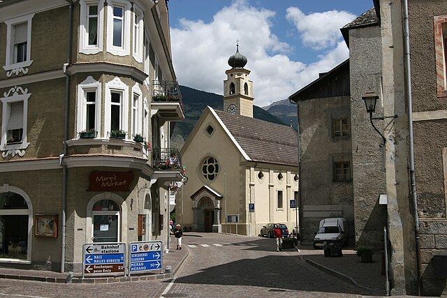
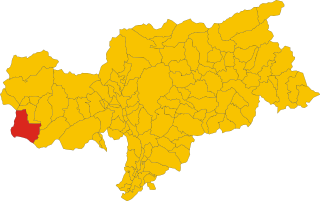
Тубре (Taufers im Münstertal, Tubre)
.svg)
- коммуна в Италии
 Hiking in Тубре
Taufers im Münstertal, located in the Bavarian Alps in South Tyrol, Italy, offers a stunning backdrop for hiking enthusiasts of all levels. The area is characterized by its picturesque valleys, lush forests, and panoramic mountain views, making it an ideal destination for nature lovers.
Hiking Trails
-
Munstertal Valley Trail: This trail runs along the Münstertal, offering a gentle walk with beautiful views of the surrounding mountains and the valley itself. It's suitable for families and novice hikers.
-
Tafamunt and Höfer Alm: A moderate hike that leads you to the Tafamunt peak with its breathtaking views. The trail takes you through lush pastures and has some steep sections, offering a rewarding panoramic view upon reaching the summit.
-
Watles and the Surrounding Area: For more experienced hikers, the trails around the Watles area offer more challenging routes with various degrees of difficulty. The views from the higher altitudes are exceptional, especially on clear days.
-
Cultural and Historical Trails: There are also trails that incorporate the rich history and culture of the region, including stops at historical churches and traditional farmhouses, which highlight the unique heritage of Taufers.
Best Time to Hike
The hiking season typically runs from late spring to early fall (May to October), with the best weather generally being in late July and August. However, always check current weather conditions and trail accessibility, especially if hiking later in the season.
Preparation and Safety
- Gear: Good hiking boots and weather-appropriate clothing are essential. A map or GPS device can be beneficial, especially for more remote trails.
- Stay Hydrated: Bring enough water and some snacks to keep your energy up during hikes.
- Respect Nature: Follow Leave No Trace principles to preserve the natural beauty of the area.
Local Amenities
Taufers im Münstertal is equipped with amenities such as guesthouses and local restaurants where you can enjoy traditional South Tyrolean cuisine after a long day of hiking. There may also be local guides available for those who prefer a guided experience.
In conclusion, Taufers im Münstertal provides a diverse range of hiking opportunities amidst breathtaking scenery, making it a fantastic region for both casual walkers and serious hikers alike. Always ensure to check local resources for trail conditions and any guided tours you may want to consider. Happy hiking!
- Страна:

- Почтовый код: 39020
- Телефонный код: 0473
- Код автомобильного номера: BZ
- Координаты: 46° 38' 39" N, 10° 27' 48" E


- GPS треки (wikiloc): [Ссылка]
- Высота над уровнем моря: 1240 м m
- Площадь: 46.27 кв.км
- Население: 981
- Веб сайт: http://www.comune.tubre.bz.it
- Википедия русская: wiki(ru)
- Википедия английская: wiki(en)
- Википедия национальная: wiki(it)
- Хранилище Wikidata: Wikidata: Q504554
- Галерея изображений в википедии: [Ссылка]
- Катеория в википедии: [Ссылка]
- код Freebase: [/m/0g9kd_]
- код GeoNames: Альт: [6535983]
- код VIAF: Альт: [237784604]
- ID отношения в OpenStreetMap: [47279]
- код GND: Альт: [4231054-4]
- идентификатор местоположения ArchINFORM: [12847]
- идентификатор HDS: [15343]
- код ISTAT: 021103
- кадастровый код Италии: L455
Граничит с регионами:

Глоренца
- коммуна Италии
Hiking in Глоренца
Glurns (or Glorenza) is a small historical town located in the South Tyrol region of northern Italy. It's nestled in the Venosta Valley and is known for its charming medieval architecture, stunning mountain scenery, and a rich cultural heritage....
- Страна:
- Почтовый код: 39020
- Телефонный код: 0473
- Код автомобильного номера: BZ
- Координаты: 46° 40' 16" N, 10° 33' 25" E
- GPS треки (wikiloc): [Ссылка]
- Высота над уровнем моря: 907 м m
- Площадь: 13.22 кв.км
- Население: 897
- Веб сайт: [Ссылка]


Маллес-Веноста
- коммуна Италии
Hiking in Маллес-Веноста
Mals, located in the Vinschgau Valley in South Tyrol, Italy, is a fantastic spot for hiking enthusiasts. Surrounded by stunning landscapes, picturesque villages, and a rich cultural heritage, it offers a variety of trails suitable for different skill levels....
- Страна:
- Почтовый код: 39024
- Телефонный код: 0473
- Код автомобильного номера: BZ
- Координаты: 46° 41' 16" N, 10° 32' 48" E
- GPS треки (wikiloc): [Ссылка]
- Высота над уровнем моря: 1051 м m
- Площадь: 247.43 кв.км
- Население: 5225
- Веб сайт: [Ссылка]


Прато-алло-Стельвио
- коммуна в Италии
Hiking in Прато-алло-Стельвио
Prad am Stilfser Joch is a charming village located in the South Tyrol region of Italy, nestled at the entrance to the Stilfser Joch National Park. This area is renowned for its stunning natural landscapes, mountainous terrain, and excellent hiking opportunities. Here are some highlights and tips for hiking in this region:...
- Страна:
- Почтовый код: 39026
- Телефонный код: 0473
- Код автомобильного номера: BZ
- Координаты: 46° 37' 8" N, 10° 35' 29" E
- GPS треки (wikiloc): [Ссылка]
- Высота над уровнем моря: 3375 м m
- Площадь: 51.49 кв.км
- Население: 3474
- Веб сайт: [Ссылка]

Стельвио
- коммуна в Италии
Hiking in Стельвио
Stilfs, also known as Stilfs or Stelvio, is a charming village located in the South Tyrol region of northern Italy. It serves as a fantastic gateway for hiking enthusiasts looking to explore the beautiful and diverse landscapes of the nearby Stelvio National Park. Here are some highlights of hiking in and around Stilfs:...
- Страна:
- Почтовый код: 39020
- Телефонный код: 0473
- Код автомобильного номера: BZ
- Координаты: 46° 35' 52" N, 10° 32' 45" E
- GPS треки (wikiloc): [Ссылка]
- Высота над уровнем моря: 1311 м m
- Площадь: 141.63 кв.км
- Население: 1150
- Веб сайт: [Ссылка]


Скуоль
Hiking in Скуоль
Scuol, located in the Swiss Engadin Valley, is a stunning destination for hiking enthusiasts. The area is known for its beautiful landscapes, picturesque alpine villages, and rich cultural heritage. Here are some highlights and tips for hiking in Scuol:...
- Страна:

- Почтовый код: 7550
- Телефонный код: 081
- Код автомобильного номера: GR
- Координаты: 46° 47' 49" N, 10° 17' 58" E
- GPS треки (wikiloc): [Ссылка]
- Высота над уровнем моря: 2368 м m
- Площадь: 438.63 кв.км
- Население: 4598
- Веб сайт: [Ссылка]


Валь Мюстаир
Hiking in Валь Мюстаир
Val Müstair is a picturesque valley located in the Swiss Alps in the Canton of Graubünden, near the border with Italy. It offers a stunning landscape characterized by its rugged mountains, lush meadows, and quaint villages. Here are some key highlights about hiking in Val Müstair:...
- Страна:
- Почтовый код: 7537
- Телефонный код: 081
- Код автомобильного номера: GR
- Координаты: 46° 36' 0" N, 10° 25' 0" E
- GPS треки (wikiloc): [Ссылка]
- Высота над уровнем моря: 1375 м m
- Площадь: 198.65 кв.км
- Население: 1511
- Веб сайт: [Ссылка]