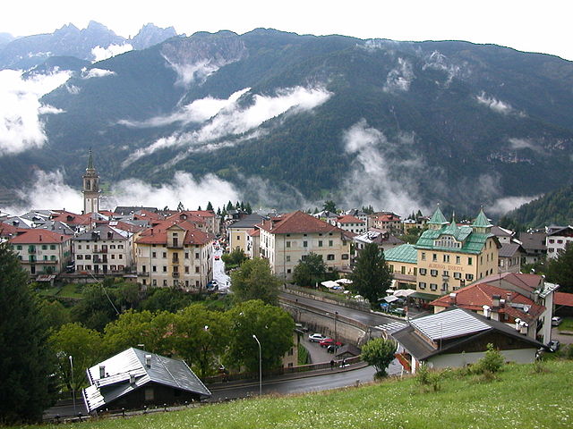
Виго-ди-Кадоре (Vigo di Cadore, Vigo di Cadore)
.svg)
- коммуна Италии
 Hiking in Виго-ди-Кадоре
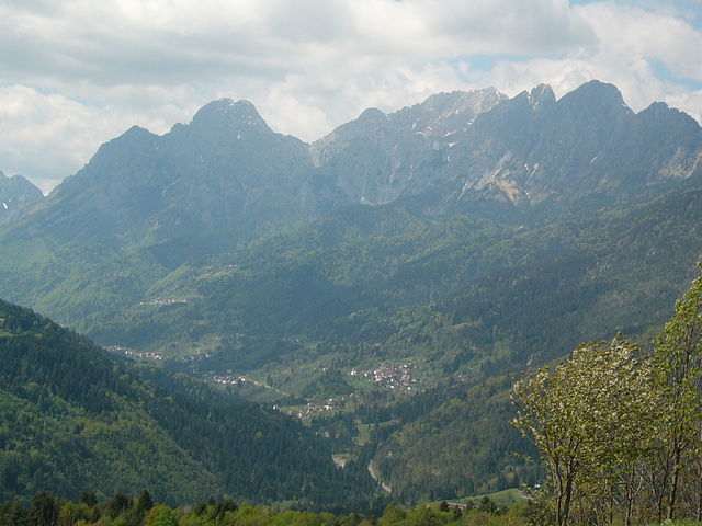
Vigo di Cadore is a picturesque village in the Dolomites, located in the Veneto region of Italy. It’s an excellent starting point for hiking enthusiasts due to its stunning landscapes, diverse trails, and rich natural and cultural heritage. Here are some highlights about hiking in Vigo di Cadore:
Trails and Routes
-
ง่ายเส้นทาง: There are several easy trails suitable for families and casual hikers. Some popular routes allow you to enjoy beautiful views without strenuous climbs.
-
Moderate Trails: For those looking for a bit more of a challenge, there are moderate hikes that lead you through lush forests and offer panoramic views of the Dolomites.
-
Challenging Hikes: Experienced hikers can embark on more challenging routes that may involve steep ascents or rough terrains. One popular hike is the trail leading to the Fossetta Pass, providing breathtaking views of the surrounding mountains.
Natural Attractions
-
Dolomiti di Sesto: You can hike in the nearby Dolomiti di Sesto, a UNESCO World Heritage Site known for its dramatic rock formations and varied ecosystems.
-
Lakes and Rivers: There are beautiful spots to hike around local lakes, such as Lake Centro Cadore, where you can enjoy serene views and peaceful surroundings.
Cultural Aspects
-
Historical Sites: Some trails may lead you to historical sites, such as ancient churches or remnants of war history, adding cultural depth to your hiking experience.
-
Local Cuisine: After a day of hiking, you can enjoy local cuisine at one of the many mountain huts or restaurants that serve traditional dishes of the region.
Best Time to Hike
The best time for hiking in Vigo di Cadore generally extends from late spring (May) to early fall (September). In summer, the weather is typically warm and pleasant, while autumn offers stunning fall foliage.
Preparation Tips
- Gear: Make sure to wear proper hiking boots and bring appropriate clothing for changing weather conditions. Layering is key.
- Maps and Guidance: It’s advisable to have a detailed map or GPS navigation, as some trails may not be well-marked.
- Hydration and Snacks: Always carry enough water and snacks, especially on longer hikes.
Local Resources
Consider visiting the local tourist office for updated trail maps, guided tours, and additional information about current trail conditions and events.
Hiking in Vigo di Cadore offers a beautiful mix of natural beauty and cultural history, making it an excellent destination for hikers of all experiences.
- Страна:

- Почтовый код: 32040
- Телефонный код: 0435
- Код автомобильного номера: BL
- Координаты: 46° 30' 0" N, 12° 28' 0" E


- GPS треки (wikiloc): [Ссылка]
- Высота над уровнем моря: 947 м m
- Площадь: 70.07 кв.км
- Население: 1409
- Веб сайт: http://www.comune.vigodicadore.bl.it
- Википедия русская: wiki(ru)
- Википедия английская: wiki(en)
- Википедия национальная: wiki(it)
- Хранилище Wikidata: Wikidata: Q39744
- Галерея изображений в википедии: [Ссылка]
- Катеория в википедии: [Ссылка]
- код Freebase: [/m/0gk2hl]
- код GeoNames: Альт: [6538291]
- код VIAF: Альт: [128273193]
- ID отношения в OpenStreetMap: [47223]
- код ISTAT: 025065
- кадастровый код Италии: L890
Граничит с регионами:


Лоццо-ди-Кадоре
- коммуна Италии
Hiking in Лоццо-ди-Кадоре
Lozzo di Cadore is a picturesque village located in the Dolomites region of Italy, known for its stunning natural landscapes and a variety of hiking opportunities. Here are some highlights about hiking in and around Lozzo di Cadore:...
- Страна:
- Почтовый код: 32040
- Телефонный код: 0435
- Код автомобильного номера: BL
- Координаты: 46° 29' 0" N, 12° 27' 0" E
- GPS треки (wikiloc): [Ссылка]
- Высота над уровнем моря: 753 м m
- Площадь: 30.4 кв.км
- Население: 1335
- Веб сайт: [Ссылка]


Ауронцо-ди-Кадоре
- коммуна Италии
Hiking in Ауронцо-ди-Кадоре
Auronzo di Cadore is a stunning destination located in the Dolomites of northeastern Italy, known for its breathtaking landscapes, rich history, and a plethora of outdoor activities, particularly hiking. Here’s an overview of what to expect when hiking in Auronzo di Cadore:...
- Страна:
- Почтовый код: 32041
- Телефонный код: 0435
- Код автомобильного номера: BL
- Координаты: 46° 33' 0" N, 12° 26' 0" E
- GPS треки (wikiloc): [Ссылка]
- Высота над уровнем моря: 862 м m
- Площадь: 220.65 кв.км
- Население: 3302
- Веб сайт: [Ссылка]

Лоренцаго-ди-Кадоре
- коммуна Италии
Hiking in Лоренцаго-ди-Кадоре
Lorenzago di Cadore, located in the heart of the Dolomites in Northern Italy, is a picturesque village that offers a wealth of hiking opportunities amidst stunning natural scenery. Here are some highlights and tips for hiking in this area:...
- Страна:
- Почтовый код: 32040
- Телефонный код: 0435
- Код автомобильного номера: BL
- Координаты: 46° 29' 0" N, 12° 28' 0" E
- GPS треки (wikiloc): [Ссылка]
- Высота над уровнем моря: 880 м m
- Площадь: 27.35 кв.км
- Население: 554
- Веб сайт: [Ссылка]
Санто-Стефано-ди-Кадоре
- коммуна Италии
Hiking in Санто-Стефано-ди-Кадоре
Santo Stefano di Cadore is a charming town located in the Dolomite region of Italy, known for its stunning landscapes, lush valleys, and impressive mountain ranges. The area offers a variety of hiking trails suited for different skill levels, making it an excellent destination for hiking enthusiasts....
- Страна:
- Почтовый код: 32045
- Телефонный код: 0435
- Код автомобильного номера: BL
- Координаты: 46° 34' 0" N, 12° 33' 0" E
- GPS треки (wikiloc): [Ссылка]
- Высота над уровнем моря: 908 м m
- Площадь: 100.62 кв.км
- Население: 2511
- Веб сайт: [Ссылка]


Форни-ди-Сопра
- коммуна Италии
Hiking in Форни-ди-Сопра
Forni di Sopra is a beautiful destination for hiking enthusiasts, located in the Friuli Venezia Giulia region of northeastern Italy. Nestled in the Carnic Alps, it offers a stunning backdrop of lush valleys, rugged mountains, and pristine landscapes. Here are some key points about hiking in Forni di Sopra:...
- Страна:
- Почтовый код: 33024
- Телефонный код: 0433
- Код автомобильного номера: UD
- Координаты: 46° 25' 0" N, 12° 35' 0" E
- GPS треки (wikiloc): [Ссылка]
- Высота над уровнем моря: 907 м m
- Площадь: 81.66 кв.км
- Население: 955
- Веб сайт: [Ссылка]

Прато-Карнико
- коммуна Италии
Hiking in Прато-Карнико
Prato Carnico is a beautiful alpine village located in the Friuli Venezia Giulia region of northeastern Italy. It's set in the Carnic Alps, offering stunning natural landscapes that are perfect for hiking enthusiasts. Here are some highlights and tips for hiking in the Prato Carnico area:...
- Страна:
- Почтовый код: 33020
- Телефонный код: 0433
- Код автомобильного номера: UD
- Координаты: 46° 31' 0" N, 12° 49' 0" E
- GPS треки (wikiloc): [Ссылка]
- Высота над уровнем моря: 686 м m
- Площадь: 81.72 кв.км
- Население: 898
- Веб сайт: [Ссылка]

Саурис
- коммуна Италии
Hiking in Саурис
Sauris, a picturesque village located in the Friuli Venezia Giulia region of Italy, is a hidden gem for hikers. Nestled in the Julian Alps, it offers stunning landscapes, rich cultural heritage, and an array of hiking trails suitable for various experience levels....
- Страна:
- Почтовый код: 33020
- Телефонный код: 0433
- Код автомобильного номера: UD
- Координаты: 46° 27' 58" N, 12° 42' 31" E
- GPS треки (wikiloc): [Ссылка]
- Высота над уровнем моря: 1212 м m
- Площадь: 41.49 кв.км
- Население: 405
- Веб сайт: [Ссылка]