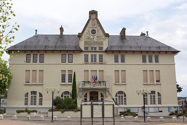
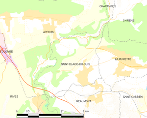
Реомон (Réaumont, Réaumont)

- коммуна во Франции
 Hiking in Реомон
Réaumont is a picturesque village located in the Isère department of the Auvergne-Rhône-Alpes region in southeastern France. It's surrounded by beautiful landscapes, making it an ideal destination for hiking enthusiasts. Here’s what you need to know when considering a hike in Réaumont:
Trails and Routes
-
Local Trails: Réaumont offers a variety of trails ranging from easy strolls to more challenging hikes. Many trails offer scenic views of the surrounding mountains and valleys.
-
Belledonne Massif: The nearby Belledonne mountain range provides numerous trails, some of which can be accessed from Réaumont. The higher elevation hikes offer breathtaking panoramas and an opportunity to explore diverse flora and fauna.
-
GR Grass Routes: The Grande Randonnée (GR) trails, including those in the vicinity, provide well-marked routes that can lead to multi-day treks. These trails connect various villages and provide an authentic experience of the French countryside.
Hiking Tips
-
Preparation: Always ensure you have a good map or download a hiking app that works offline. Familiarize yourself with the trail details and difficulty levels.
-
Gear: Dress in layers and wear sturdy hiking boots. Bring trekking poles if you plan on tackling more challenging terrains, and don't forget essentials like a first-aid kit, water, and snacks.
-
Weather: Check the local weather forecast before you go. Conditions in the mountains can change rapidly, so be prepared for different weather scenarios.
-
Wildlife and Nature: Keep an eye out for local wildlife and unique plant species. Respect the natural environment and follow Leave No Trace principles.
When to Hike
-
Best Seasons: Spring and autumn typically offer the best hiking conditions in Réaumont. The weather is mild, and you can enjoy beautiful foliage during these seasons.
-
Summer: While summer is also a great time for hiking, remember that popular trails can be more crowded, and temperatures can be higher, especially in lower elevations.
Local Amenities
Réaumont has some local facilities such as cafés and restaurants where you can enjoy a meal after a day's hike. It’s a good idea to check the operating hours before your visit, especially in the off-peak tourist seasons.
Conclusion
Hiking in Réaumont offers a wonderful opportunity to explore the natural beauty of the French Alps. With a mix of trails suitable for hikers of all levels, it is a fantastic destination for both seasoned explorers and families. Happy hiking!
- Страна:

- Почтовый код: 38140
- Координаты: 45° 22' 11" N, 5° 31' 33" E


- GPS треки (wikiloc): [Ссылка]
- Площадь: 4.95 кв.км
- Население: 1037
- Веб сайт: http://mairie-reaumont.fr/
- Википедия русская: wiki(ru)
- Википедия английская: wiki(en)
- Википедия национальная: wiki(fr)
- Хранилище Wikidata: Wikidata: Q1068592
- Катеория в википедии: [Ссылка]
- код Freebase: [/m/03nvj9m]
- код GeoNames: Альт: [6424365]
- номер SIREN: [213803315]
- код муниципалитета INSEE: 38331
Граничит с регионами:

Рив
Hiking in Рив
Rives, located in the Isère department of the Auvergne-Rhône-Alpes region in southeastern France, offers a range of outdoor activities, including hiking. The area is characterized by its picturesque landscapes, mountainous terrain, and proximity to the French Alps, making it a great starting point for various hiking adventures....
- Страна:
- Почтовый код: 38140
- Координаты: 45° 21' 3" N, 5° 30' 8" E
- GPS треки (wikiloc): [Ссылка]
- Площадь: 10.93 кв.км
- Население: 6242
- Веб сайт: [Ссылка]


Шарнекль
- коммуна во Франции
Hiking in Шарнекль
Charnècles is a charming village located in the Isère department of the Auvergne-Rhône-Alpes region in France. It offers a scenic backdrop for hiking enthusiasts, with various trails that showcase the area's natural beauty and rich landscapes....
- Страна:
- Почтовый код: 38140
- Координаты: 45° 20' 36" N, 5° 31' 40" E
- GPS треки (wikiloc): [Ссылка]
- Площадь: 5.23 кв.км
- Население: 1505
- Веб сайт: [Ссылка]

Сен-Блез-дю-Бюи
- коммуна во Франции
Hiking in Сен-Блез-дю-Бюи
Saint-Blaise-du-Buis, located in the Isère department in southeastern France, is a great destination for hiking enthusiasts who appreciate nature and stunning landscapes. This area is characterized by its beautiful scenery, rolling hills, and a mix of forested areas and open fields, making it a picturesque spot for outdoor activities....
- Страна:
- Почтовый код: 38140
- Координаты: 45° 22' 37" N, 5° 31' 6" E
- GPS треки (wikiloc): [Ссылка]
- Площадь: 5.44 кв.км
- Население: 1028
- Веб сайт: [Ссылка]

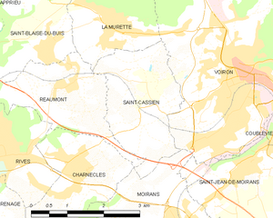
Сен-Касьян
Hiking in Сен-Касьян
Saint-Cassien, located in the Isère department of France, is a tranquil and beautiful area that offers a variety of hiking opportunities. Nestled in the scenic foothills of the French Alps, it features diverse landscapes, including forests, rivers, and stunning mountain vistas....
- Страна:
- Почтовый код: 38500
- Координаты: 45° 21' 36" N, 5° 33' 12" E
- GPS треки (wikiloc): [Ссылка]
- Площадь: 5.67 кв.км
- Население: 1143
- Веб сайт: [Ссылка]


Муаран
- коммуна во Франции
Hiking in Муаран
Moirans, located in the Auvergne-Rhône-Alpes region of France, is surrounded by beautiful landscapes that are perfect for hiking enthusiasts. Here are some key points to consider if you're planning a hiking trip in this area:...
- Страна:
- Почтовый код: 38430
- Координаты: 45° 19' 30" N, 5° 33' 52" E
- GPS треки (wikiloc): [Ссылка]
- Площадь: 20.06 кв.км
- Население: 8022
- Веб сайт: [Ссылка]


Ла-Мюретт
- коммуна во Франции
Hiking in Ла-Мюретт
La Murette is a small village located in the French Alps, specifically within the Isère department. It's nestled in a picturesque landscape offering a variety of hiking opportunities that cater to different skill levels....
- Страна:
- Почтовый код: 38140
- Координаты: 45° 22' 52" N, 5° 32' 23" E
- GPS треки (wikiloc): [Ссылка]
- Площадь: 4.22 кв.км
- Население: 1931