Raynans (Raynans)

- коммуна во Франции
 Hiking in Raynans
Raynans is a small village in the Jura department of eastern France, known for its picturesque landscapes and proximity to the Jura mountain range. Hiking in this region offers a variety of trails suitable for different skill levels, and provides a chance to experience the beauty of nature, including lush forests, rolling hills, and scenic viewpoints.
Hiking Trails and Areas:
-
Local Trails: There are several marked hiking trails around Raynans that cater to various abilities. These trails often lead through forests, past rivers, and up into elevated areas that provide stunning views of the surrounding landscape.
-
Jura Mountains: The nearby Jura mountains have numerous hiking opportunities, with trails that range from easy walks to challenging hikes. The GR 5 long-distance walking route runs through this area, offering a more extensive hiking experience.
-
Nature Reserves: Exploring nearby nature reserves or parks can be rewarding. The Haut-Jura Regional Nature Park offers well-maintained trails and the chance to see diverse flora and fauna.
Tips for Hiking in Raynans:
-
Check Trail Maps: Before heading out, it's a good idea to get a trail map or use a hiking app to familiarize yourself with the paths, distances, and difficulty levels.
-
Weather Preparedness: The weather in the Jura region can change rapidly. Be prepared with appropriate clothing and gear, including waterproofs if necessary.
-
Stay Hydrated: Bring plenty of water and snacks, especially if you're planning on longer hikes.
-
Respect Nature: Follow Leave No Trace principles by staying on designated trails, taking your trash with you, and respecting wildlife.
-
Safety: Make sure someone knows your hiking plan, and consider hiking with a buddy, especially on more remote trails.
Hiking in Raynans can be a serene and invigorating experience, allowing you to connect with nature while enjoying the tranquility of the beautiful Jura region.
- Страна:

- Почтовый код: 25550
- Координаты: 47° 31' 59" N, 6° 43' 8" E


- GPS треки (wikiloc): [Ссылка]
- Площадь: 4.03 кв.км
- Население: 343
- Википедия английская: wiki(en)
- Википедия национальная: wiki(fr)
- Хранилище Wikidata: Wikidata: Q905024
- Катеория в википедии: [Ссылка]
- код Freebase: [/m/03mhc8r]
- код Freebase: [/m/03mhc8r]
- код GeoNames: Альт: [6429955]
- код GeoNames: Альт: [6429955]
- номер SIREN: [212504815]
- номер SIREN: [212504815]
- код BNF: [152527072]
- код BNF: [152527072]
- код муниципалитета INSEE: 25481
- код муниципалитета INSEE: 25481
Граничит с регионами:
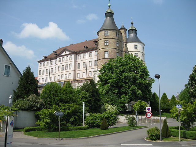

Монбельяр
- коммуна во Франции
Hiking in Монбельяр
Montbéliard, a picturesque town located in the Bourgogne-Franche-Comté region of eastern France, offers various hiking opportunities that allow you to explore the beautiful landscapes and rich history of the area....
- Страна:
- Почтовый код: 25200
- Координаты: 47° 30' 35" N, 6° 47' 54" E
- GPS треки (wikiloc): [Ссылка]
- Высота над уровнем моря: 337 м m
- Площадь: 15.01 кв.км
- Население: 25336
- Веб сайт: [Ссылка]


Échenans
- коммуна во Франции
Hiking in Échenans
Échenans is a small commune in the Bourgogne-Franche-Comté region of France, located near the city of Montbéliard. While Échenans itself may not be widely recognized as a major hiking destination, the surrounding areas offer opportunities for hiking enthusiasts....
- Страна:
- Почтовый код: 25550
- Координаты: 47° 31' 34" N, 6° 41' 43" E
- GPS треки (wikiloc): [Ссылка]
- Высота над уровнем моря: 345 м m
- Площадь: 1.7 кв.км
- Население: 155


Aibre
- коммуна во Франции
Hiking in Aibre
It seems there may be a typo or misunderstanding regarding "Aibre," as there isn’t a well-known hiking location by that name in commonly referenced hiking guides or maps. However, if you're referring to a particular area or if it’s a local name, I’d be happy to help with general hiking advice or information about popular hiking destinations in your region....
- Страна:
- Почтовый код: 25750
- Координаты: 47° 33' 4" N, 6° 41' 48" E
- GPS треки (wikiloc): [Ссылка]
- Площадь: 4.5 кв.км
- Население: 480


Laire
- коммуна во Франции
Hiking in Laire
Laire is not widely recognized as a specific hiking destination, so it's possible that you meant a different location—or that Laire may be a less-known area with trails. If you are referring to a region or national park, like in the French Alps, Pyrenees, or anywhere else specifically, please clarify, and I will be happy to provide information on that area....
- Страна:
- Почтовый код: 25550
- Координаты: 47° 33' 2" N, 6° 43' 58" E
- GPS треки (wikiloc): [Ссылка]
- Площадь: 3.17 кв.км
- Население: 395


Issans
- коммуна во Франции
Hiking in Issans
It seems there might be a typo in your inquiry, as there isn't a well-known hiking destination called "Issans." However, if you meant "Islands," I could provide information about hiking on islands such as those in the Caribbean, Pacific, or other regions. Alternatively, if you're referring to a specific location or region that sounds similar, please clarify so I can assist you better!...
- Страна:
- Почтовый код: 25550
- Координаты: 47° 31' 39" N, 6° 43' 40" E
- GPS треки (wikiloc): [Ссылка]
- Площадь: 2.72 кв.км
- Население: 247

Semondans
- коммуна во Франции
Hiking in Semondans
Semondans is a small commune in the Doubs department in the Bourgogne-Franche-Comté region of eastern France. While it may not be as widely known for hiking as some larger national parks or mountainous regions, there are still opportunities for outdoor activities in the surrounding area....
- Страна:
- Почтовый код: 25750
- Координаты: 47° 32' 34" N, 6° 41' 35" E
- GPS треки (wikiloc): [Ссылка]
- Площадь: 2.77 кв.км
- Население: 298


Saint-Julien-lès-Montbéliard
- коммуна во Франции
Hiking in Saint-Julien-lès-Montbéliard
Saint-Julien-lès-Montbéliard is a charming commune located in the Bourgogne-Franche-Comté region of France, near the town of Montbéliard. The area is characterized by its beautiful natural landscapes, hills, and forests, making it a great destination for hiking enthusiasts....
- Страна:
- Почтовый код: 25550
- Координаты: 47° 31' 20" N, 6° 42' 38" E
- GPS треки (wikiloc): [Ссылка]
- Площадь: 3.81 кв.км
- Население: 168