
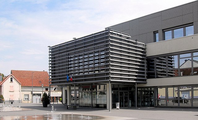
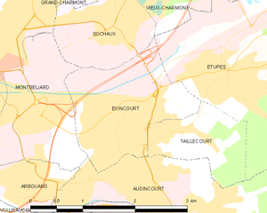
Монбельяр (Montbéliard, Montbéliard)

- коммуна во Франции
 Hiking in Монбельяр
Montbéliard, a picturesque town located in the Bourgogne-Franche-Comté region of eastern France, offers various hiking opportunities that allow you to explore the beautiful landscapes and rich history of the area.
Hiking Trails
-
Bans - La Petite Montagne: This nearby area features trails that range from easy to moderately challenging, offering stunning views of the surrounding countryside. It’s perfect for a day hike, and you can enjoy the tranquility of nature.
-
The Montbéliard Forest: The forest surrounding Montbéliard features a network of well-marked trails. Hiking here provides a chance to see diverse flora and fauna, especially beautiful during the spring and fall seasons when the colors are vibrant.
-
Côte de Morteau: Slightly further out, this area offers more rugged terrain and views of the Doubs river. The trails can be challenging, making them suitable for experienced hikers looking for an adventure.
-
Sentier des Vignes: This trail takes you through vineyards and offers a different type of hiking experience, showcasing the agricultural beauty of the region. It’s an easier hike, ideal for families.
Local Landmarks
While hiking, be sure to check out local landmarks such as:
- Château de Montbéliard: This historic castle offers insights into the region's history and boasts stunning views from its hilltop position.
- Basilique Saint-Maurice: This impressive church is a great place to visit either before or after your hike.
Practical Tips
- Best Time to Hike: Spring and fall are the most pleasant times for hiking in Montbéliard due to the mild temperatures and scenic beauty.
- Gear: Wear appropriate hiking shoes, and consider carrying trekking poles if you're tackling more challenging trails.
- Food and Water: Bring enough water and snacks, especially if you're planning a longer hike, as amenities in remote areas can be sparse.
Safety Considerations
- Always check the weather forecast before heading out and let someone know your hiking plans.
- It’s wise to have a map or GPS device, as some trails may not be well marked.
Exploring the hiking trails around Montbéliard can be a rewarding experience, combining physical activity with the enjoyment of scenic landscapes and local culture!
- Страна:

- Почтовый код: 25200
- Координаты: 47° 30' 35" N, 6° 47' 54" E


- GPS треки (wikiloc): [Ссылка]
- Высота над уровнем моря: 337 м m
- Площадь: 15.01 кв.км
- Население: 25336
- Веб сайт: http://www.montbeliard.com
- Википедия русская: wiki(ru)
- Википедия английская: wiki(en)
- Википедия национальная: wiki(fr)
- Хранилище Wikidata: Wikidata: Q154715
- Катеория в википедии: [Ссылка]
- Карты в википедии: [Ссылка]
- код Freebase: [/m/01f8wy]
- код Freebase: [/m/01f8wy]
- код Freebase: [/m/01f8wy]
- код GeoNames: Альт: [2992938]
- код GeoNames: Альт: [2992938]
- код GeoNames: Альт: [2992938]
- номер SIREN: [212503882]
- номер SIREN: [212503882]
- номер SIREN: [212503882]
- код BNF: [152526142]
- код BNF: [152526142]
- код BNF: [152526142]
- код VIAF: Альт: [155890847]
- код VIAF: Альт: [155890847]
- код VIAF: Альт: [155890847]
- код GND: Альт: [4074960-5]
- код GND: Альт: [4074960-5]
- код GND: Альт: [4074960-5]
- идентификатор местоположения ArchINFORM: [7726]
- идентификатор местоположения ArchINFORM: [7726]
- идентификатор местоположения ArchINFORM: [7726]
- код LCNAF: Альт: [n82106917]
- код LCNAF: Альт: [n82106917]
- код LCNAF: Альт: [n82106917]
- место в MusicBrainz: [7f090c48-ac0d-4d4a-b403-ce74ff601e32]
- место в MusicBrainz: [7f090c48-ac0d-4d4a-b403-ce74ff601e32]
- место в MusicBrainz: [7f090c48-ac0d-4d4a-b403-ce74ff601e32]
- код темы Quora: [Montbéliard]
- код темы Quora: [Montbéliard]
- код темы Quora: [Montbéliard]
- код в энциклопедии «Британника онлайн»: [place/Montbeliard]
- код в энциклопедии «Британника онлайн»: [place/Montbeliard]
- код в энциклопедии «Британника онлайн»: [place/Montbeliard]
- код в Encyclopædia Universalis: [montbeliard]
- код в Encyclopædia Universalis: [montbeliard]
- код в Encyclopædia Universalis: [montbeliard]
- EMLO location ID: [399ed870-a1c6-4700-84a7-809f5688b10c]
- EMLO location ID: [399ed870-a1c6-4700-84a7-809f5688b10c]
- EMLO location ID: [399ed870-a1c6-4700-84a7-809f5688b10c]
- код GAMEO: [Montbéliard (Doubs, Franche-Comté, France)]
- код GAMEO: [Montbéliard (Doubs, Franche-Comté, France)]
- код GAMEO: [Montbéliard (Doubs, Franche-Comté, France)]
- код муниципалитета INSEE: 25388
- код муниципалитета INSEE: 25388
- код муниципалитета INSEE: 25388
Граничит с регионами:


Сошо
- коммуна во Франции
Hiking in Сошо
Sochaux is a small town in the Bourgogne-Franche-Comté region of France, primarily known for its industrial history, particularly with the Peugeot automobile company. While Sochaux itself may not be a well-known hiking destination, there are several outdoor opportunities and trails in the surrounding areas that you might explore....
- Страна:
- Почтовый код: 25600
- Координаты: 47° 30' 52" N, 6° 49' 53" E
- GPS треки (wikiloc): [Ссылка]
- Площадь: 2.17 кв.км
- Население: 3978
- Веб сайт: [Ссылка]


Arbouans
- коммуна во Франции
Hiking in Arbouans
Arbouans is a small region near Montbéliard in France, known for its picturesque landscapes and scenic trails. While specific hiking trails in Arbouans may not be widely documented, the surrounding region offers appealing options for outdoor enthusiasts....
- Страна:
- Почтовый код: 25400
- Координаты: 47° 29' 26" N, 6° 48' 37" E
- GPS треки (wikiloc): [Ссылка]
- Площадь: 1.32 кв.км
- Население: 943


Laire
- коммуна во Франции
Hiking in Laire
Laire is not widely recognized as a specific hiking destination, so it's possible that you meant a different location—or that Laire may be a less-known area with trails. If you are referring to a region or national park, like in the French Alps, Pyrenees, or anywhere else specifically, please clarify, and I will be happy to provide information on that area....
- Страна:
- Почтовый код: 25550
- Координаты: 47° 33' 2" N, 6° 43' 58" E
- GPS треки (wikiloc): [Ссылка]
- Площадь: 3.17 кв.км
- Население: 395

Audincourt
- коммуна во Франции
Hiking in Audincourt
Audincourt is a charming town located in the Bourgogne-Franche-Comté region of France, nestled near the city of Montbéliard. While it may not be as widely known for hiking as some other areas, there are opportunities for outdoor enthusiasts to explore the natural beauty of the surrounding region. Here are a few points to consider if you're planning to hike in and around Audincourt:...
- Страна:
- Почтовый код: 25400
- Координаты: 47° 28' 58" N, 6° 50' 23" E
- GPS треки (wikiloc): [Ссылка]
- Площадь: 8.76 кв.км
- Население: 14121
- Веб сайт: [Ссылка]

Эксенкур
- коммуна во Франции
Hiking in Эксенкур
Exincourt is a small commune in the Doubs department in the Bourgogne-Franche-Comté region of eastern France. While Exincourt itself may not be widely known for hiking, its location near the Jura Mountains and the Doubs River offers access to various scenic hiking opportunities in the surrounding areas....
- Страна:
- Почтовый код: 25400
- Координаты: 47° 29' 51" N, 6° 49' 59" E
- GPS треки (wikiloc): [Ссылка]
- Площадь: 3.45 кв.км
- Население: 3214
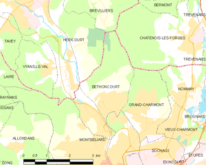
Bethoncourt
- коммуна во Франции
Hiking in Bethoncourt
Bethoncourt is a small commune located in the Doubs department in the Bourgogne-Franche-Comté region of eastern France. While it's not as widely known for hiking as some of the larger national parks or tourist destinations, it still offers opportunities for outdoor enthusiasts to explore the nearby countryside....
- Страна:
- Почтовый код: 25200
- Координаты: 47° 32' 4" N, 6° 48' 14" E
- GPS треки (wikiloc): [Ссылка]
- Площадь: 6.54 кв.км
- Население: 5652
- Веб сайт: [Ссылка]

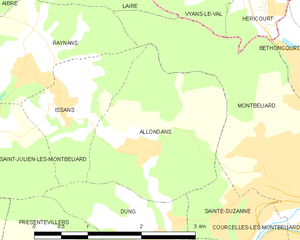
Allondans
- коммуна во Франции
Hiking in Allondans
Allondans, a small village located in the Haute-Saône department of the Bourgogne-Franche-Comté region in eastern France, offers a range of hiking opportunities that showcase the scenic beauty of the surrounding countryside. While it might not be as famous as some other hiking destinations in France, its charm lies in its tranquil landscapes and local trails....
- Страна:
- Почтовый код: 25550
- Координаты: 47° 31' 9" N, 6° 44' 51" E
- GPS треки (wikiloc): [Ссылка]
- Площадь: 5.14 кв.км
- Население: 245


Courcelles-lès-Montbéliard
- коммуна во Франции
Hiking in Courcelles-lès-Montbéliard
Courcelles-lès-Montbéliard is a charming village located in the Doubs department in the Bourgogne-Franche-Comté region of France. This area offers various hiking opportunities that cater to different skill levels and preferences....
- Страна:
- Почтовый код: 25420
- Координаты: 47° 30' 0" N, 6° 47' 10" E
- GPS треки (wikiloc): [Ссылка]
- Площадь: 2.4 кв.км
- Население: 1174


Grand-Charmont
- коммуна во Франции
Hiking in Grand-Charmont
Grand-Charmont is a charming commune located in the Bourgogne-Franche-Comté region of eastern France. While it may not be as widely known as some national parks or larger hiking destinations, the surrounding area offers a variety of outdoor activities, including hiking....
- Страна:
- Почтовый код: 25200
- Координаты: 47° 31' 38" N, 6° 49' 25" E
- GPS треки (wikiloc): [Ссылка]
- Площадь: 4.56 кв.км
- Население: 5584
- Веб сайт: [Ссылка]


Raynans
- коммуна во Франции
Hiking in Raynans
Raynans is a small village in the Jura department of eastern France, known for its picturesque landscapes and proximity to the Jura mountain range. Hiking in this region offers a variety of trails suitable for different skill levels, and provides a chance to experience the beauty of nature, including lush forests, rolling hills, and scenic viewpoints....
- Страна:
- Почтовый код: 25550
- Координаты: 47° 31' 59" N, 6° 43' 8" E
- GPS треки (wikiloc): [Ссылка]
- Площадь: 4.03 кв.км
- Население: 343


Issans
- коммуна во Франции
Hiking in Issans
It seems there might be a typo in your inquiry, as there isn't a well-known hiking destination called "Issans." However, if you meant "Islands," I could provide information about hiking on islands such as those in the Caribbean, Pacific, or other regions. Alternatively, if you're referring to a specific location or region that sounds similar, please clarify so I can assist you better!...
- Страна:
- Почтовый код: 25550
- Координаты: 47° 31' 39" N, 6° 43' 40" E
- GPS треки (wikiloc): [Ссылка]
- Площадь: 2.72 кв.км
- Население: 247


Sainte-Suzanne
- коммуна во Франции
Hiking in Sainte-Suzanne
Sainte-Suzanne, located in the Doubs department of France, is a beautiful area known for its stunning landscapes and rich natural heritage, making it a great destination for hiking enthusiasts. Here are some key highlights and tips for hiking in this region:...
- Страна:
- Почтовый код: 25630
- Координаты: 47° 30' 22" N, 6° 46' 21" E
- GPS треки (wikiloc): [Ссылка]
- Площадь: 1.59 кв.км
- Население: 1557


Вьян-ле-Валь
- коммуна во Франции
Hiking in Вьян-ле-Валь
Vyans-le-Val is a small commune in the Jura department in eastern France, characterized by its picturesque landscapes, lush forests, and scenic trails. Hiking in this region can be an enriching experience, offering a mix of natural beauty and serene countryside....
- Страна:
- Почтовый код: 70400
- Координаты: 47° 33' 0" N, 6° 46' 2" E
- GPS треки (wikiloc): [Ссылка]
- Высота над уровнем моря: 360 м m
- Площадь: 3.32 кв.км
- Население: 464