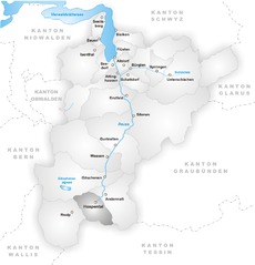
Реальп (Realp, Realp)

- коммуна в Швейцарии
 Hiking in Реальп
Realp is a charming village located in the Uri canton of Switzerland, nestled in the heart of the Swiss Alps. It's an excellent destination for hiking enthusiasts, offering a variety of trails that cater to different skill levels and preferences. Here are some highlights for hiking in and around Realp:
Trail Options
-
Realp to Furka Pass: This scenic route allows hikers to experience stunning views of the surrounding mountains and glaciers. It's a moderately challenging hike that showcases the beauty of the Swiss Alps.
-
Rotondohütte and the Rotondo Peak: This trail offers an ascent to Rotondohütte, where you can enjoy picturesque views of the surrounding peaks and valleys. The hike can be challenging, but it rewards you with stunning landscapes.
-
Hiking to the Rhone Glacier: A popular route that leads you to one of the last remaining glaciers in the Alps. The hike provides an educational experience about glacial erosion and its impacts on the environment.
-
Uristier: This is a family-friendly trail that is suitable for hikers of all ages and skill levels. The path is well-marked, and the incredible views make it perfect for a leisurely hike.
Tips for Hiking in Realp
-
Check the Weather: The weather in the Alps can change rapidly, so always check the forecast before heading out and be prepared for varying conditions.
-
Footwear: Wear sturdy hiking boots with good grip to handle uneven terrain.
-
Stay Hydrated: Carry plenty of water, especially on longer hikes, as some trails may not have water sources.
-
Map and Navigation: While many trails are well-marked, it’s advisable to carry a physical map or a GPS device, as cell service may be limited in remote areas.
-
Wildlife and Nature: Be respectful of the natural environment. Keep a safe distance from wildlife, and remember to stick to designated trails.
Local Amenities
After a day of hiking, Realp offers several amenities, including cozy mountain lodges and restaurants where you can enjoy local Swiss cuisine. Staying in Realp also provides access to various other outdoor activities, including biking and climbing, making it a great base for an active vacation.
Whether you're a seasoned hiker or a beginner, Realp's trails provide an opportunity to immerse yourself in stunning alpine scenery and experience the tranquility of the Swiss mountains. Happy hiking!
- Страна:

- Почтовый код: 6491
- Телефонный код: 041
- Код автомобильного номера: UR
- Координаты: 46° 35' 55" N, 8° 30' 11" E


- GPS треки (wikiloc): [Ссылка]
- Высота над уровнем моря: 1538 м m
- Площадь: 78.04 кв.км
- Население: 151
- Веб сайт: http://www.realp.ch
- Википедия русская: wiki(ru)
- Википедия английская: wiki(en)
- Википедия национальная: wiki(de)
- Хранилище Wikidata: Wikidata: Q67161
- Катеория в википедии: [Ссылка]
- код Freebase: [/m/0fwqbk]
- код GeoNames: Альт: [2659092]
- код VIAF: Альт: [245839287]
- ID отношения в OpenStreetMap: [1683095]
- идентификатор местоположения ArchINFORM: [8875]
- идентификатор HDS: [701]
- код швейцарского муниципалитета: [1212]
Граничит с регионами:

Хоспенталь
- коммуна в Швейцарии
Hiking in Хоспенталь
Hospental is a picturesque village located in the Ursern Valley of the Swiss canton of Uri, nestled within the stunning landscapes of the Swiss Alps. Hiking in and around Hospental offers a range of options for all ability levels, from easy, family-friendly trails to more challenging alpine hikes. Here are some highlights and tips about hiking in this beautiful region:...
- Страна:
- Почтовый код: 6493
- Телефонный код: 041
- Код автомобильного номера: UR
- Координаты: 46° 37' 14" N, 8° 34' 12" E
- GPS треки (wikiloc): [Ссылка]
- Высота над уровнем моря: 1493 м m
- Площадь: 35.0 кв.км
- Население: 191
- Веб сайт: [Ссылка]


Bedretto
Hiking in Bedretto
Bedretto, a picturesque valley located in the Swiss Alps, is a fantastic destination for hiking enthusiasts. Nestled between the mountain chains of the Lepontine Alps, it offers breathtaking landscapes, lush meadows, and a range of trails suitable for various skill levels....
- Страна:
- Почтовый код: 6781
- Телефонный код: 091
- Код автомобильного номера: TI
- Координаты: 46° 30' 0" N, 8° 31' 0" E
- GPS треки (wikiloc): [Ссылка]
- Высота над уровнем моря: 1402 м m
- Площадь: 75.2 кв.км
- Население: 109
- Веб сайт: [Ссылка]

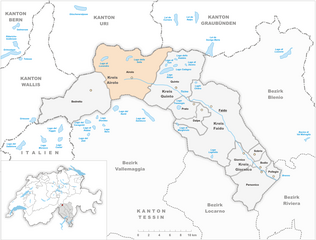
Airolo
Hiking in Airolo
Airolo, located in the Ticino canton of Switzerland, is an excellent destination for hiking enthusiasts. It sits at the foot of the Gotthard Pass and offers a variety of trails that cater to different skill levels, from leisurely walks to more challenging treks....
- Страна:
- Почтовый код: 6781; 6780
- Телефонный код: 091
- Код автомобильного номера: TI
- Координаты: 46° 32' 0" N, 8° 37' 0" E
- GPS треки (wikiloc): [Ссылка]
- Высота над уровнем моря: 2132 м m
- Площадь: 94.5 кв.км
- Население: 1527
- Веб сайт: [Ссылка]


Гёшенен
- коммуна в Швейцарии
Hiking in Гёшенен
Göschenen is a picturesque village in the Uri canton of Switzerland, located at the entrance to the Gotthard region, and it offers a variety of hiking opportunities for outdoor enthusiasts. Here are some highlights:...
- Страна:
- Почтовый код: 6487
- Телефонный код: 041
- Код автомобильного номера: UR
- Координаты: 46° 39' 50" N, 8° 29' 56" E
- GPS треки (wikiloc): [Ссылка]
- Высота над уровнем моря: 2430 м m
- Площадь: 10431 кв.км
- Население: 462
- Веб сайт: [Ссылка]