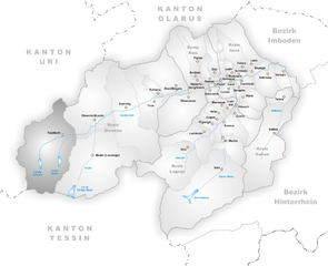
Airolo (Airolo)

 Hiking in Airolo
Airolo, located in the Ticino canton of Switzerland, is an excellent destination for hiking enthusiasts. It sits at the foot of the Gotthard Pass and offers a variety of trails that cater to different skill levels, from leisurely walks to more challenging treks.
Key Highlights for Hiking in Airolo:
-
Main Trails:
- Valle di Bedretto: This valley features breathtaking scenery with its lush green meadows and panoramic views of the surrounding mountains. There are several marked trails here, suitable for both beginners and experienced hikers.
- Gotthard Pass Trail: This historic trail follows parts of the old mule paths used by traders and travelers. It provides a great way to appreciate the cultural history of the region while enjoying stunning mountain vistas.
-
Scenic Views: The area around Airolo is known for its dramatic landscapes, including towering peaks, alpine meadows, and crystal-clear streams. It is especially beautiful in spring and summer when the wildflowers bloom.
-
Wildlife and Nature: Hikers in Airolo may encounter a variety of wildlife, including ibex and marmots, particularly in the higher elevations. The diverse flora and fauna add to the natural beauty of the area.
-
Accessibility: Airolo is accessible by train and car, making it an easy destination for both local and international hikers. The nearby cable cars and funiculars can help you reach higher elevations with less effort, allowing for more options in your hiking adventures.
-
Guided Tours: For those who prefer guided experiences, there are local hiking organizations that offer led tours. These can be a great way to learn more about the area and its natural history.
-
Safety and Preparation: As with any hiking adventure, it’s crucial to prepare adequately. Make sure to check trail conditions, dress in layers, stay hydrated, and carry a map or GPS device. Weather can change rapidly in the mountains, so being prepared is key.
-
Accommodation and Amenities: Airolo has various accommodation options, from hotels to guesthouses, making it convenient for multi-day hikes. There are also restaurants and shops for resupplying.
Best Time to Hike:
The best hiking season in Airolo generally runs from late spring (around May) to early autumn (September), when the weather is mild and the trails are clear of snow.
Additional Tips:
- Always stick to marked trails.
- Inform someone of your hiking plans, especially if you’re venturing into remote areas.
- Respect wildlife and the natural environment, practicing Leave No Trace principles.
Overall, Airolo is a fantastic base for exploring the Swiss Alps, offering an array of hiking opportunities amidst stunning natural beauty. Happy hiking!
- Страна:

- Почтовый код: 6781; 6780
- Телефонный код: 091
- Код автомобильного номера: TI
- Координаты: 46° 32' 0" N, 8° 37' 0" E


- GPS треки (wikiloc): [Ссылка]
- Высота над уровнем моря: 2132 м m
- Площадь: 94.5 кв.км
- Население: 1527
- Веб сайт: http://www.airolo.ch
- Википедия английская: wiki(en)
- Википедия национальная: wiki(de)
- Хранилище Wikidata: Wikidata: Q69265
- Катеория в википедии: [Ссылка]
- код Freebase: [/m/03g085]
- код GeoNames: Альт: [7285044]
- код VIAF: Альт: [148887001]
- ID отношения в OpenStreetMap: [1684612]
- код GND: Альт: [4453169-2]
- идентификатор местоположения ArchINFORM: [17437]
- код LCNAF: Альт: [n00041571]
- код TGN: [7007244]
- код в Большой каталанской энциклопедии: [0001393]
- идентификатор HDS: [2065]
- код швейцарского муниципалитета: [5061]
Граничит с регионами:


Андерматт
- коммуна в Швейцарии
Hiking in Андерматт
Andermatt, nestled in the Swiss Alps, is a captivating hub for hiking enthusiasts. Known for its stunning alpine scenery, Andermatt offers a wide range of trails suitable for various skill levels, from beginners to seasoned hikers....
- Страна:
- Почтовый код: 6490
- Телефонный код: 041
- Код автомобильного номера: UR
- Координаты: 46° 37' 14" N, 8° 37' 53" E
- GPS треки (wikiloc): [Ссылка]
- Высота над уровнем моря: 1753 м m
- Площадь: 62.2 кв.км
- Население: 1354
- Веб сайт: [Ссылка]

Туеч
Hiking in Туеч
Tujetsch is a beautiful municipality located in the canton of Graubünden in Switzerland, known for its stunning landscapes and outdoor recreational opportunities. Hiking in Tujetsch offers a variety of trails suitable for different skill levels, ranging from leisurely walks to more challenging hikes. Here are some highlights and tips for hiking in this picturesque region:...
- Страна:
- Почтовый код: 7188
- Телефонный код: 081
- Код автомобильного номера: GR
- Координаты: 46° 40' 59" N, 8° 46' 0" E
- GPS треки (wikiloc): [Ссылка]
- Высота над уровнем моря: 1450 м m
- Площадь: 134 кв.км
- Население: 1256
- Веб сайт: [Ссылка]

Хоспенталь
- коммуна в Швейцарии
Hiking in Хоспенталь
Hospental is a picturesque village located in the Ursern Valley of the Swiss canton of Uri, nestled within the stunning landscapes of the Swiss Alps. Hiking in and around Hospental offers a range of options for all ability levels, from easy, family-friendly trails to more challenging alpine hikes. Here are some highlights and tips about hiking in this beautiful region:...
- Страна:
- Почтовый код: 6493
- Телефонный код: 041
- Код автомобильного номера: UR
- Координаты: 46° 37' 14" N, 8° 34' 12" E
- GPS треки (wikiloc): [Ссылка]
- Высота над уровнем моря: 1493 м m
- Площадь: 35.0 кв.км
- Население: 191
- Веб сайт: [Ссылка]


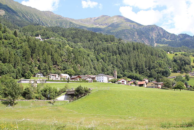
Bedretto
Hiking in Bedretto
Bedretto, a picturesque valley located in the Swiss Alps, is a fantastic destination for hiking enthusiasts. Nestled between the mountain chains of the Lepontine Alps, it offers breathtaking landscapes, lush meadows, and a range of trails suitable for various skill levels....
- Страна:
- Почтовый код: 6781
- Телефонный код: 091
- Код автомобильного номера: TI
- Координаты: 46° 30' 0" N, 8° 31' 0" E
- GPS треки (wikiloc): [Ссылка]
- Высота над уровнем моря: 1402 м m
- Площадь: 75.2 кв.км
- Население: 109
- Веб сайт: [Ссылка]


Реальп
- коммуна в Швейцарии
Hiking in Реальп
Realp is a charming village located in the Uri canton of Switzerland, nestled in the heart of the Swiss Alps. It's an excellent destination for hiking enthusiasts, offering a variety of trails that cater to different skill levels and preferences. Here are some highlights for hiking in and around Realp:...
- Страна:
- Почтовый код: 6491
- Телефонный код: 041
- Код автомобильного номера: UR
- Координаты: 46° 35' 55" N, 8° 30' 11" E
- GPS треки (wikiloc): [Ссылка]
- Высота над уровнем моря: 1538 м m
- Площадь: 78.04 кв.км
- Население: 151
- Веб сайт: [Ссылка]

Quinto
Hiking in Quinto
Quinto is a picturesque village located in the southern part of Switzerland, specifically in the Ticino canton. This area is renowned for its stunning landscapes, rich natural diversity, and variety of hiking trails. Here are some highlights for hiking in and around Quinto:...
- Страна:
- Почтовый код: 6777
- Телефонный код: 091
- Код автомобильного номера: TI
- Координаты: 46° 31' 0" N, 8° 42' 0" E
- GPS треки (wikiloc): [Ссылка]
- Высота над уровнем моря: 1915 м m
- Площадь: 75.2 кв.км
- Население: 1044
- Веб сайт: [Ссылка]


Lavizzara
Hiking in Lavizzara
Lavizzara is a beautiful region located in the southern part of Switzerland, specifically in the Ticino canton. It is well-known for its stunning landscapes, rich natural beauty, and picturesque mountain views, making it an excellent destination for hiking enthusiasts....
- Страна:
- Почтовый код: 6695
- Телефонный код: 091
- Код автомобильного номера: TI
- Координаты: 46° 26' 0" N, 8° 39' 0" E
- GPS треки (wikiloc): [Ссылка]
- Высота над уровнем моря: 702 м m
- Площадь: 187.21 кв.км
- Население: 526
- Веб сайт: [Ссылка]