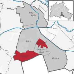
Рудов (Rudow, Rudow)

- район в Берлине
 Hiking in Рудов
Rudow is a district in the borough of Neukölln in Berlin, Germany. Although it is primarily an urban area and not known for traditional hiking, there are opportunities for walks and exploring nature in and around the district. Here are some options and tips for hiking or walking in and around Rudow:
-
Nature Reserves: The nearby "Dannenwalde" and "Hermannswerder" nature reserves provide a more natural setting where you can enjoy walking trails, bird watching, and the local flora and fauna.
-
Walking Trails: While Rudow may not have dedicated hiking trails, you can still find local paths and parks. For example, the nearby Britzer Garten offers landscaped paths and beautiful gardens for leisurely strolls.
-
Green Spaces: Make use of the local parks such as the "Rudower Höhe" park, which has various walking paths and green areas perfect for short hikes.
-
Connection to Larger Trail Systems: The district is fairly close to larger green areas like the Tempelhofer Feld, an abandoned airport turned park where you can walk, cycle, and explore open spaces.
-
Urban Hiking: You can also engage in urban hiking in Rudow by exploring the neighborhood’s architecture, local culture, and small shops. Consider planning a route that connects to other interesting districts in Berlin.
-
Public Transportation Access: Use Berlin's efficient public transport system to reach more extensive hiking areas outside of the city, such as the surrounding hills and forests in Brandenburg.
Remember to wear comfortable shoes, bring enough water, and consider checking the weather before setting out. Enjoy your walk in Rudow!
- Страна:

- Почтовый код: 12357; 12355; 12353
- Координаты: 52° 25' 0" N, 13° 30' 0" E


- GPS треки (wikiloc): [Ссылка]
- Высота над уровнем моря: 38 м m
- Площадь: 11.8 кв.км
- Население: 41618
- Википедия русская: wiki(ru)
- Википедия английская: wiki(en)
- Википедия национальная: wiki(de)
- Хранилище Wikidata: Wikidata: Q614664
- Галерея изображений в википедии: [Ссылка]
- Катеория в википедии: [Ссылка]
- код Freebase: [/m/0bwh_hq]
- код GeoNames: Альт: [2843350]
- код VIAF: Альт: [239968276]
- ID отношения в OpenStreetMap: [55757]
- код GND: Альт: [4224418-3]
- идентификатор местоположения ArchINFORM: [43235]
Граничит с регионами:


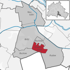
Бриц
- район в Берлине
Hiking in Бриц
Britz is a neighborhood located in the borough of Neukölln in Berlin, Germany. It is not particularly known for hiking in the traditional sense, as it is more urban and residential in nature. However, there are some fantastic parks and green areas nearby that offer opportunities for leisurely walks and nature exploration....
- Страна:
- Почтовый код: 12359; 12347
- Координаты: 52° 27' 0" N, 13° 26' 0" E
- GPS треки (wikiloc): [Ссылка]
- Высота над уровнем моря: 44 м m
- Площадь: 12.4 кв.км
- Население: 41613


Альтглинике
- район в Берлине
Hiking in Альтглинике
Altglienicke is a district located in the southeastern part of Berlin, Germany. While it's primarily urban and residential, there are still some opportunities for hiking enthusiasts to enjoy nature nearby. Here are some aspects to consider if you're planning to hike in or around Altglienicke:...
- Страна:
- Координаты: 52° 25' 0" N, 13° 32' 0" E
- GPS треки (wikiloc): [Ссылка]
- Высота над уровнем моря: 34 м m
- Площадь: 7.89 кв.км
- Население: 26426


Баумшуленвег
- район в Берлине
Hiking in Баумшуленвег
Baumschulenweg is a neighborhood located in the Treptow-Köpenick district of Berlin, Germany. While it may not be well-known as a traditional hiking destination, there are several outdoor opportunities in and around the area for those looking to enjoy nature and scenic walks....
- Страна:
- Координаты: 52° 27' 54" N, 13° 29' 10" E
- GPS треки (wikiloc): [Ссылка]
- Высота над уровнем моря: 37 м m
- Площадь: 4.82 кв.км
- Население: 17186

Букков
- район в Берлине
Hiking in Букков
Buckow is a charming district located in the borough of Neukölln in Berlin, Germany. While it may not be a traditional hiking hotspot, it does offer some lovely outdoor experiences, especially for those interested in walking, nature, and exploring the surrounding areas....
- Страна:
- Почтовый код: 12353; 12351; 12349
- Координаты: 52° 25' 55" N, 13° 27' 42" E
- GPS треки (wikiloc): [Ссылка]
- Высота над уровнем моря: 44 м m
- Площадь: 6.35 кв.км
- Население: 39184


Йоханнисталь
- район в Берлине
Hiking in Йоханнисталь
Johannisthal is a district in Berlin that is primarily known for its residential areas and proximity to green spaces rather than hiking trails. However, you can still enjoy outdoor activities and lighter hiking options in and around the area....
- Страна:
- Координаты: 52° 26' 36" N, 13° 30' 8" E
- GPS треки (wikiloc): [Ссылка]
- Высота над уровнем моря: 37 м m
- Площадь: 6.54 кв.км

Гропиусштадт
- район в Берлине
Hiking in Гропиусштадт
Gropiusstadt is a district in Berlin, Germany, known primarily for its modernist architecture and urban planning, rather than traditional hiking trails. However, there are opportunities for walking and exploring green spaces in and around Gropiusstadt....
- Страна:
- Почтовый код: 12353; 12351
- Координаты: 52° 25' 33" N, 13° 27' 41" E
- GPS треки (wikiloc): [Ссылка]
- Высота над уровнем моря: 52 м m
- Площадь: 2.66 кв.км
- Население: 36542