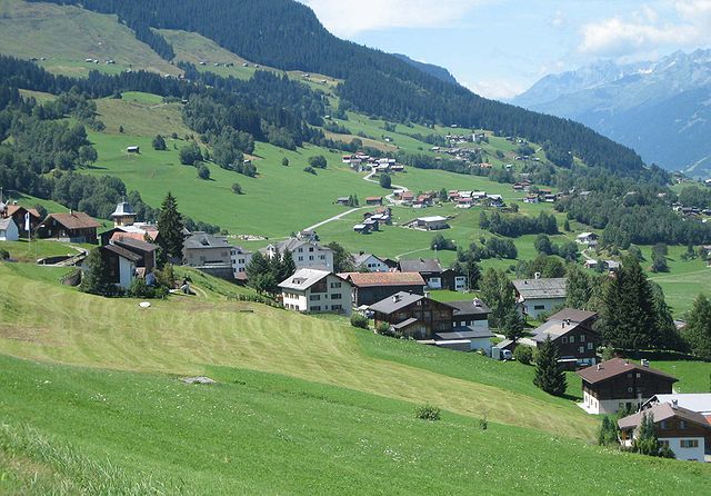
Руэун (Rueun, Rueun)

 Hiking in Руэун
Rueun is a picturesque village located in the Swiss canton of Graubünden, nestled among the stunning landscapes of the Swiss Alps. It serves as a great base for hiking enthusiasts looking to explore the natural beauty of the region. Here are some key points to know about hiking in and around Rueun:
Trails and Routes
-
Diverse Terrain: The region offers a variety of hiking trails suitable for all skill levels, from easy walks suitable for families to more challenging hikes for experienced adventurers.
-
Scenic Views: Many trails provide breathtaking views of the surrounding mountains, valleys, and traditional Swiss architecture. Be prepared to see stunning alpine meadows, serene lakes, and majestic peaks.
-
Local Highlights: Popular hikes may include routes leading to nearby landmarks such as the Rhine Gorge (often referred to as the “Grand Canyon of Switzerland”) or the scenic paths around the Surselva region.
Best Seasons for Hiking
- Summer (June to September): This is the prime hiking season in Rueun, with warm temperatures and accessible trails. Wildflowers bloom, and the landscape is lush and green.
- Fall (October): Early October can still offer good hiking weather, and the autumn foliage adds beautiful colors to the scenery. However, be aware of the potential for early snow at higher elevations.
Preparation Tips
- Gear: Ensure you have appropriate hiking gear, including sturdy footwear, weather-appropriate clothing, and a good backpack. Trekking poles can be helpful for steep or uneven terrain.
- Maps & Guides: Carry a physical map or download hiking apps to help navigate the trails. Signage is generally good, but it’s always best to be prepared.
Safety Considerations
- Stay on Marked Trails: To preserve the natural environment, stick to marked paths and follow local regulations.
- Inform Others: If hiking alone or on lesser-known trails, let someone know your plan and expected return time.
- Wildlife: Keep an eye out for wildlife, and maintain a respectful distance if you encounter animals.
Local Culture
- Experience the local culture by stopping at mountain huts or small restaurants along the trails to enjoy traditional Swiss cuisine, which often includes hearty dishes perfect for recharging after a hike.
If you plan to hike in Rueun, ensure that you are well-prepared and equipped for the conditions you might encounter. Enjoy the stunning alpine landscapes, and happy hiking!
- Страна:

- Почтовый код: 7156
- Телефонный код: 081
- Код автомобильного номера: GR
- Координаты: 46° 45' 59" N, 9° 8' 59" E


- GPS треки (wikiloc): [Ссылка]
- Высота над уровнем моря: 788 м m
- Площадь: 11.58 кв.км
- Веб сайт: http://www.rueun.ch
- Википедия русская: wiki(ru)
- Википедия английская: wiki(en)
- Википедия национальная: wiki(de)
- Хранилище Wikidata: Wikidata: Q66003
- Катеория в википедии: [Ссылка]
- код Freebase: [/m/0g7qrt]
- код GeoNames: Альт: [2658933]
- код VIAF: Альт: [245404139]
- ID отношения в OpenStreetMap: [1684143]
- идентификатор HDS: [1468]
- код швейцарского муниципалитета: [3614]
Граничит с регионами:


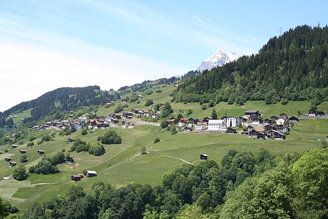
Иланц
Hiking in Иланц
Ilanz, located in the beautiful Surselva region of the Swiss canton of Graubünden, offers a range of stunning hiking opportunities. Known as the "Gateway to the Rhine Canyon," Ilanz serves as a great base for exploring the surrounding natural landscapes. Here are some highlights and tips for hiking in the Ilanz area:...
- Страна:
- Почтовый код: 7130
- Телефонный код: 081
- Координаты: 46° 45' 59" N, 9° 12' 0" E
- GPS треки (wikiloc): [Ссылка]
- Высота над уровнем моря: 702 м m
- Площадь: 4.67 кв.км
- Веб сайт: [Ссылка]

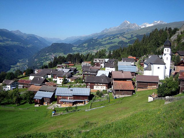
Оберзаксен
Hiking in Оберзаксен
Obersaxen is a beautiful region located in the scenic Swiss Alps, specifically in the canton of Graubünden. It is known for its stunning landscapes, diverse trails, and outdoor activities, making it an excellent destination for hiking enthusiasts. Here are some highlights and tips for hiking in Obersaxen:...
- Страна:
- Почтовый код: 7134
- Телефонный код: 081
- Координаты: 46° 44' 0" N, 9° 6' 0" E
- GPS треки (wikiloc): [Ссылка]
- Высота над уровнем моря: 1281 м m
- Площадь: 61.77 кв.км
- Веб сайт: [Ссылка]


Вальтенсбург
Hiking in Вальтенсбург
Waltensburg-Vuorz is a beautiful destination located in the Graubünden region of Switzerland, known for its stunning landscapes and outdoor activities, including hiking. The area offers a variety of trails that cater to different skill levels, making it an ideal spot for both casual hikers and experienced trekkers....
- Страна:
- Почтовый код: 7158
- Телефонный код: 081
- Код автомобильного номера: GR
- Координаты: 46° 46' 35" N, 9° 7' 0" E
- GPS треки (wikiloc): [Ссылка]
- Высота над уровнем моря: 1876 м m
- Площадь: 32.31 кв.км
- Население: 325
- Веб сайт: [Ссылка]

Андиаст
Hiking in Андиаст
Andiast is a picturesque village located in the canton of Graubünden in Switzerland, known for its stunning landscapes and excellent hiking opportunities. Nestled in the Swiss Alps, it offers a variety of trails suitable for hikers of all levels, from leisurely walks to more challenging treks....
- Страна:
- Почтовый код: 7159
- Телефонный код: 081
- Код автомобильного номера: GR
- Координаты: 46° 46' 59" N, 9° 6' 59" E
- GPS треки (wikiloc): [Ссылка]
- Высота над уровнем моря: 1178 м m
- Площадь: 13.63 кв.км
- Население: 211
- Веб сайт: [Ссылка]


Шнаус
Hiking in Шнаус
Schnaus, located in the Swiss region of Graubünden, is renowned for its picturesque landscapes and diverse hiking trails. While specific trail information may vary, here’s a general guide to help you enjoy hiking in this beautiful area:...
- Страна:
- Почтовый код: 7130
- Телефонный код: 081
- Код автомобильного номера: GR
- Координаты: 46° 45' 59" N, 9° 9' 59" E
- GPS треки (wikiloc): [Ссылка]
- Высота над уровнем моря: 720 м m
- Площадь: 2.97 кв.км

Сиат
Hiking in Сиат
Siat is a charming village located in the picturesque region of the Swiss Alps. While it may not be as well-known as some major hiking destinations in Switzerland, it offers a range of beautiful trails and outdoor experiences for those looking to explore its stunning landscapes....
- Страна:
- Почтовый код: 7157
- Телефонный код: 081
- Код автомобильного номера: GR
- Координаты: 46° 46' 59" N, 9° 9' 0" E
- GPS треки (wikiloc): [Ссылка]
- Высота над уровнем моря: 1296 м m
- Площадь: 13.48 кв.км
- Население: 181
- Веб сайт: [Ссылка]


Пиньиу
Hiking in Пиньиу
Pigniu is a small village located in the Swiss canton of Grisons (Graubünden), known for its stunning alpine scenery and charming landscapes. Hiking in this region offers a variety of trails that cater to different skill levels, making it a great destination for both beginners and experienced hikers....
- Страна:
- Почтовый код: 7156
- Телефонный код: 081
- Код автомобильного номера: GR
- Координаты: 46° 47' 59" N, 9° 5' 59" E
- GPS треки (wikiloc): [Ссылка]
- Высота над уровнем моря: 1301 м m
- Площадь: 17.98 кв.км
- Веб сайт: [Ссылка]


Mundaun
Hiking in Mundaun
Mundaun is a beautiful region in the Swiss Alps, known for its stunning landscapes, diverse flora and fauna, and well-marked hiking trails. Located in the canton of Graubünden, Mundaun offers a range of hiking experiences suitable for various skill levels. Here’s what you can expect when hiking in Mundaun:...
- Страна:
- Почтовый код: 7137
- Телефонный код: 081
- Код автомобильного номера: GR
- Координаты: 46° 45' 0" N, 9° 8' 0" E
- GPS треки (wikiloc): [Ссылка]
- Высота над уровнем моря: 1072 м m
- Площадь: 8.59 кв.км
- Веб сайт: [Ссылка]