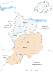
Сиат (Siat, Siat)

 Hiking in Сиат
Siat is a charming village located in the picturesque region of the Swiss Alps. While it may not be as well-known as some major hiking destinations in Switzerland, it offers a range of beautiful trails and outdoor experiences for those looking to explore its stunning landscapes.
Popular Hiking Trails:
-
Siat to the Latterrugia:
- A moderately challenging hike that takes you through lush forests and meadows, offering breathtaking views of the surrounding peaks. The trail often includes beautiful alpine flowers in the summer.
-
Siat to Fläsch:
- This is a great option for those looking for a less strenuous hike. The path meanders through scenic countryside, providing opportunities to spot local wildlife and enjoy the tranquility of the region.
-
Pizalun Peak:
- For the more adventurous hikers, a route leading up to Pizalun offers stunning panoramic views of the Alps. This hike requires a good level of fitness and some route finding, so it's best suited for experienced hikers.
Tips for Hiking in Siat:
-
Season: The best times to hike in Siat are during late spring through early autumn when the weather is mild, and the trails are fully accessible.
-
Gear: Make sure to wear proper hiking boots and bring essentials like water, snacks, a map, and a first aid kit. Depending on the trail, hiking poles can also be beneficial.
-
Weather: Be sure to check the weather conditions before heading out, as mountain weather can change rapidly.
-
Local Regulations: Respect the local environment and stick to marked trails to minimize your impact on nature.
Additional Activities:
- Besides hiking, Siat is an excellent location for mountain biking and wildlife photography. In the winter, the area offers opportunities for snowshoeing and skiing.
Accessibility:
Siat is reachable by public transportation from major Swiss cities, but having a car can provide more flexibility in exploring surrounding areas and more remote trails.
Whether you're a seasoned hiker or a beginner looking to enjoy the beauty of the Swiss Alps, Siat offers a peaceful and less-traveled hiking experience. Enjoy your adventure!
- Страна:

- Почтовый код: 7157
- Телефонный код: 081
- Код автомобильного номера: GR
- Координаты: 46° 46' 59" N, 9° 9' 0" E


- GPS треки (wikiloc): [Ссылка]
- Высота над уровнем моря: 1296 м m
- Площадь: 13.48 кв.км
- Население: 181
- Веб сайт: http://www.siat.ch
- Википедия русская: wiki(ru)
- Википедия английская: wiki(en)
- Википедия национальная: wiki(de)
- Хранилище Wikidata: Wikidata: Q65716
- Катеория в википедии: [Ссылка]
- код Freebase: [/m/026gnqk]
- код GeoNames: Альт: [8299584]
- код VIAF: Альт: [128916704]
- ID отношения в OpenStreetMap: [1684167]
- идентификатор HDS: [1469]
- код швейцарского муниципалитета: [3615]
- код ISNI: Альт: [0000 0001 1512 1989]
Граничит с регионами:


Шнаус
Hiking in Шнаус
Schnaus, located in the Swiss region of Graubünden, is renowned for its picturesque landscapes and diverse hiking trails. While specific trail information may vary, here’s a general guide to help you enjoy hiking in this beautiful area:...
- Страна:
- Почтовый код: 7130
- Телефонный код: 081
- Код автомобильного номера: GR
- Координаты: 46° 45' 59" N, 9° 9' 59" E
- GPS треки (wikiloc): [Ссылка]
- Высота над уровнем моря: 720 м m
- Площадь: 2.97 кв.км


Руэун
Hiking in Руэун
Rueun is a picturesque village located in the Swiss canton of Graubünden, nestled among the stunning landscapes of the Swiss Alps. It serves as a great base for hiking enthusiasts looking to explore the natural beauty of the region. Here are some key points to know about hiking in and around Rueun:...
- Страна:
- Почтовый код: 7156
- Телефонный код: 081
- Код автомобильного номера: GR
- Координаты: 46° 45' 59" N, 9° 8' 59" E
- GPS треки (wikiloc): [Ссылка]
- Высота над уровнем моря: 788 м m
- Площадь: 11.58 кв.км
- Веб сайт: [Ссылка]


Рушайн
Hiking in Рушайн
Ruschein, located in the Grisons region of Switzerland, offers beautiful landscapes and a variety of hiking trails suitable for all levels of experience. The area is characterized by stunning alpine scenery, including lush meadows, rugged mountains, and picturesque valleys....
- Страна:
- Почтовый код: 7154
- Телефонный код: 081
- Код автомобильного номера: GR
- Координаты: 46° 46' 59" N, 9° 11' 0" E
- GPS треки (wikiloc): [Ссылка]
- Высота над уровнем моря: 1155 м m
- Площадь: 12.54 кв.км
- Веб сайт: [Ссылка]


Пиньиу
Hiking in Пиньиу
Pigniu is a small village located in the Swiss canton of Grisons (Graubünden), known for its stunning alpine scenery and charming landscapes. Hiking in this region offers a variety of trails that cater to different skill levels, making it a great destination for both beginners and experienced hikers....
- Страна:
- Почтовый код: 7156
- Телефонный код: 081
- Код автомобильного номера: GR
- Координаты: 46° 47' 59" N, 9° 5' 59" E
- GPS треки (wikiloc): [Ссылка]
- Высота над уровнем моря: 1301 м m
- Площадь: 17.98 кв.км
- Веб сайт: [Ссылка]

Glarus Süd
Hiking in Glarus Süd
Glarus Süd, located in the canton of Glarus in Switzerland, is a fantastic destination for hiking enthusiasts. This region boasts stunning landscapes, ranging from lush valleys to rugged mountain terrains. Here are some key points about hiking in Glarus Süd:...
- Страна:
- Почтовый код: 8756, 8762, 8765, 8766, 8767, 8772, 8773, 8774, 8775, 8777, 8782, 8783, 8784
- Телефонный код: 055
- Код автомобильного номера: GL
- Координаты: 46° 59' 40" N, 9° 4' 27" E
- GPS треки (wikiloc): [Ссылка]
- Высота над уровнем моря: 521 м m
- Площадь: 430.2 кв.км
- Население: 9581
- Веб сайт: [Ссылка]