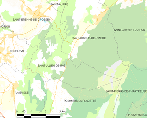
Сент-Этьенн-де-Кросе (Saint-Étienne-de-Crossey, Saint-Étienne-de-Crossey)

- коммуна во Франции
 Hiking in Сент-Этьенн-де-Кросе
Saint-Étienne-de-Crossey is a charming commune located in the Isère department of the Auvergne-Rhône-Alpes region in southeastern France. It is surrounded by stunning natural landscapes, making it a great destination for hiking enthusiasts. Here are some highlights and tips for hiking in this area:
-
Scenic Trails: The region offers a variety of hiking trails that cater to different skill levels, from easy walks to more challenging hikes. You can enjoy beautiful views of the Chartreuse Mountains and the surrounding countryside.
-
Nature Reserves: The vicinity includes several natural reserves where you can explore diverse flora and fauna. Take the time to observe the local wildlife while enjoying the tranquility of nature.
-
Local Terrain: The terrain around Saint-Étienne-de-Crossey features a mix of forests, meadows, and hills. Make sure to equip yourself with proper hiking boots and clothing that suits the weather, as conditions can change rapidly.
-
Cultural Landmarks: Along some of the hiking routes, you may come across historical sites, such as old chapels or ruins, which can enhance your hiking experience by providing a glimpse into the local heritage.
-
Maps and Guides: Before heading out, it's wise to obtain maps or guides of the trails in the area. The local tourist office or hiking clubs can provide valuable information about trail conditions and recommended hikes.
-
Safety Tips: Always inform someone about your hiking plans, carry sufficient water and snacks, and check the weather forecast before you set out. Additionally, consider hiking with a group or a guide if you are unfamiliar with the area.
-
Seasonal Considerations: Spring and early autumn are generally the best times for hiking due to mild temperatures and favorable conditions. In winter, certain trails may be accessible for snowshoeing, but it's important to be cautious of snow and ice.
Exploring the hiking trails around Saint-Étienne-de-Crossey is a rewarding way to experience the natural beauty of the region. Enjoy your adventure!
- Страна:

- Почтовый код: 38960
- Координаты: 45° 22' 45" N, 5° 38' 44" E


- GPS треки (wikiloc): [Ссылка]
- Площадь: 12.84 кв.км
- Население: 2550
- Веб сайт: http://www.st-etienne-de-crossey.fr
- Википедия русская: wiki(ru)
- Википедия английская: wiki(en)
- Википедия национальная: wiki(fr)
- Хранилище Wikidata: Wikidata: Q1067777
- Катеория в википедии: [Ссылка]
- код Freebase: [/m/03nvhc0]
- код GeoNames: Альт: [6433339]
- номер SIREN: [213803836]
- код BNF: [152581938]
- код LCNAF: Альт: [no2018114861]
- WOEID: [623890]
- код муниципалитета INSEE: 38383
Граничит с регионами:


Сен-Никола-де-Машерен
- коммуна во Франции
Hiking in Сен-Никола-де-Машерен
Saint-Nicolas-de-Macherin is a charming village located in the Auvergne-Rhône-Alpes region of France. While it may not be as well-known as some larger hiking destinations, it offers plenty of opportunities for outdoor enthusiasts to explore natural beauty, scenic landscapes, and local wildlife....
- Страна:
- Почтовый код: 38500
- Координаты: 45° 23' 54" N, 5° 36' 24" E
- GPS треки (wikiloc): [Ссылка]
- Площадь: 10.6 кв.км
- Население: 913
- Веб сайт: [Ссылка]

Сен-Жюльен-де-Ра
- коммуна во Франции
Hiking in Сен-Жюльен-де-Ра
Saint-Julien-de-Raz is a charming commune in the Vaucluse department of the Provence-Alpes-Côte d'Azur region in southeastern France. Although it's not widely known as a major hiking destination, it offers access to beautiful natural surroundings that are ideal for those interested in exploring the great outdoors....
- Страна:
- Почтовый код: 38134
- Координаты: 45° 20' 59" N, 5° 39' 42" E
- GPS треки (wikiloc): [Ссылка]
- Высота над уровнем моря: 630 м m
- Площадь: 10.81 кв.км
- Население: 429
- Веб сайт: [Ссылка]


Кублеви
- коммуна во Франции
Hiking in Кублеви
Coublevie is a charming village located in the Auvergne-Rhône-Alpes region of France, set near the foothills of the Alps. This region offers a variety of hiking opportunities for outdoor enthusiasts. Here are some key points to consider when hiking in and around Coublevie:...
- Страна:
- Почтовый код: 38500
- Координаты: 45° 21' 20" N, 5° 37' 0" E
- GPS треки (wikiloc): [Ссылка]
- Площадь: 7.05 кв.км
- Население: 4680
- Веб сайт: [Ссылка]


Сент-Опр
- коммуна во Франции
Hiking in Сент-Опр
Saint-Aupre is a charming commune located in the Isère department in the Auvergne-Rhône-Alpes region of France. It's surrounded by stunning natural landscapes, making it an excellent destination for hiking enthusiasts....
- Страна:
- Почтовый код: 38960
- Координаты: 45° 23' 58" N, 5° 40' 14" E
- GPS треки (wikiloc): [Ссылка]
- Площадь: 11.93 кв.км
- Население: 1123
- Веб сайт: [Ссылка]


Вуарон
- коммуна во Франции
Hiking in Вуарон
Voiron, located in the Isère department in the Auvergne-Rhône-Alpes region of France, is surrounded by beautiful natural landscapes, making it an excellent destination for hiking enthusiasts. Here are some highlights about hiking around Voiron:...
- Страна:
- Почтовый код: 38500
- Координаты: 45° 21' 48" N, 5° 35' 24" E
- GPS треки (wikiloc): [Ссылка]
- Площадь: 21.9 кв.км
- Население: 20529
- Веб сайт: [Ссылка]


Сен-Жозеф-де-Ривьер
- коммуна во Франции
Hiking in Сен-Жозеф-де-Ривьер
Saint-Joseph-de-Rivière is a charming village located in the Isère department in the Auvergne-Rhône-Alpes region of France. This area is surrounded by beautiful natural landscapes, making it an appealing destination for hiking enthusiasts....
- Страна:
- Почтовый код: 38134
- Координаты: 45° 22' 33" N, 5° 41' 49" E
- GPS треки (wikiloc): [Ссылка]
- Площадь: 17.39 кв.км
- Население: 1218
- Веб сайт: [Ссылка]