.jpg)
Вуарон (Voiron, Voiron)

- коммуна во Франции
 Hiking in Вуарон
Voiron, located in the Isère department in the Auvergne-Rhône-Alpes region of France, is surrounded by beautiful natural landscapes, making it an excellent destination for hiking enthusiasts. Here are some highlights about hiking around Voiron:
Scenic Trails
-
Balcony of Voiron (Balcon de Voiron): This trail offers stunning views of the surrounding mountains, including the Chartreuse and Belledonne ranges. The hike is moderate and ideal for enjoying panoramic views.
-
Chaine de Belledonne: Just a short drive from Voiron, this mountain range has many trails catering to all levels. You can find everything from easy walks to challenging ascents, such as to the peak of the Grand Pic de Belledonne.
-
Chartreuse Regional Natural Park: Located a bit further, this park offers numerous well-marked trails, stunning limestone cliffs, and forests. The park is perfect for both day hikes and longer treks.
Difficulty Levels
- Family-Friendly Trails: Many trails around Voiron are suitable for families and beginners, providing gentle slopes and beautiful scenery.
- Challenging Hikes: For more experienced hikers, trails in the Belledonne mountain range offer steeper paths and higher altitudes.
Seasonal Considerations
- Spring and Summer: This is the peak hiking season in Voiron. The weather is mild, and wildflowers bloom, decorating the trails.
- Fall: Autumn colors enhance the hiking experience, with cooler temperatures perfect for outdoor activities.
- Winter: Some trails are accessible but may require snowshoes or other winter gear. Always check local conditions.
Local Tips
- Safety: Make sure to carry enough water, snacks, and a map or GPS device. Cell service may be limited in some areas.
- Guided Tours: For those who prefer, there are local guides and organized group hikes available, offering insights into the region's flora, fauna, and geology.
Getting There
Voiron is accessible by train or car, and once in the area, many trailheads are within a short drive or a convenient distance for walking.
Conclusion
Hiking in Voiron combines beautiful scenery, diverse trail options, and the rich natural environment of the French Alps, making it a wonderful destination for hikers of all levels. Whether you're looking for a leisurely stroll or a challenging climb, you'll find trails that suit your interests and abilities. Enjoy your outdoor adventure!
- Страна:

- Почтовый код: 38500
- Координаты: 45° 21' 48" N, 5° 35' 24" E


- GPS треки (wikiloc): [Ссылка]
- Площадь: 21.9 кв.км
- Население: 20529
- Веб сайт: http://www.ville-voiron.fr
- Википедия русская: wiki(ru)
- Википедия английская: wiki(en)
- Википедия национальная: wiki(fr)
- Хранилище Wikidata: Wikidata: Q238205
- Галерея изображений в википедии: [Ссылка]
- Катеория в википедии: [Ссылка]
- код Freebase: [/m/04s1qx]
- код GeoNames: Альт: [2967758]
- номер SIREN: [213805633]
- код BNF: [15258363w]
- код VIAF: Альт: [161108647]
- код GND: Альт: [4108362-3]
- код LCNAF: Альт: [n82006709]
- код тезауруса PACTOLS: [pcrto1sXBXrN9p]
- место в MusicBrainz: [bf0fb305-83b4-4e5c-a832-620b8d06e5dd]
- WOEID: [632571]
- код темы Quora: [Voiron]
- код муниципалитета INSEE: 38563
Граничит с регионами:


Сент-Этьенн-де-Кросе
- коммуна во Франции
Hiking in Сент-Этьенн-де-Кросе
Saint-Étienne-de-Crossey is a charming commune located in the Isère department of the Auvergne-Rhône-Alpes region in southeastern France. It is surrounded by stunning natural landscapes, making it a great destination for hiking enthusiasts. Here are some highlights and tips for hiking in this area:...
- Страна:
- Почтовый код: 38960
- Координаты: 45° 22' 45" N, 5° 38' 44" E
- GPS треки (wikiloc): [Ссылка]
- Площадь: 12.84 кв.км
- Население: 2550
- Веб сайт: [Ссылка]


Сен-Никола-де-Машерен
- коммуна во Франции
Hiking in Сен-Никола-де-Машерен
Saint-Nicolas-de-Macherin is a charming village located in the Auvergne-Rhône-Alpes region of France. While it may not be as well-known as some larger hiking destinations, it offers plenty of opportunities for outdoor enthusiasts to explore natural beauty, scenic landscapes, and local wildlife....
- Страна:
- Почтовый код: 38500
- Координаты: 45° 23' 54" N, 5° 36' 24" E
- GPS треки (wikiloc): [Ссылка]
- Площадь: 10.6 кв.км
- Население: 913
- Веб сайт: [Ссылка]


Сен-Жан-де-Муаран
- коммуна во Франции
Hiking in Сен-Жан-де-Муаран
Saint-Jean-de-Moirans is located in the Auvergne-Rhône-Alpes region of France, nestled at the foot of the Chartreuse Mountains. This picturesque area offers a variety of hiking opportunities that cater to different skill levels, from leisurely walks to more challenging treks....
- Страна:
- Почтовый код: 38430
- Координаты: 45° 20' 28" N, 5° 34' 56" E
- GPS треки (wikiloc): [Ссылка]
- Площадь: 6.43 кв.км
- Население: 3427
- Веб сайт: [Ссылка]


Кублеви
- коммуна во Франции
Hiking in Кублеви
Coublevie is a charming village located in the Auvergne-Rhône-Alpes region of France, set near the foothills of the Alps. This region offers a variety of hiking opportunities for outdoor enthusiasts. Here are some key points to consider when hiking in and around Coublevie:...
- Страна:
- Почтовый код: 38500
- Координаты: 45° 21' 20" N, 5° 37' 0" E
- GPS треки (wikiloc): [Ссылка]
- Площадь: 7.05 кв.км
- Население: 4680
- Веб сайт: [Ссылка]

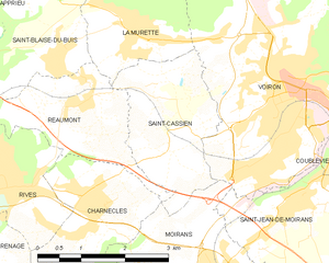
Сен-Касьян
Hiking in Сен-Касьян
Saint-Cassien, located in the Isère department of France, is a tranquil and beautiful area that offers a variety of hiking opportunities. Nestled in the scenic foothills of the French Alps, it features diverse landscapes, including forests, rivers, and stunning mountain vistas....
- Страна:
- Почтовый код: 38500
- Координаты: 45° 21' 36" N, 5° 33' 12" E
- GPS треки (wikiloc): [Ссылка]
- Площадь: 5.67 кв.км
- Население: 1143
- Веб сайт: [Ссылка]


Муаран
- коммуна во Франции
Hiking in Муаран
Moirans, located in the Auvergne-Rhône-Alpes region of France, is surrounded by beautiful landscapes that are perfect for hiking enthusiasts. Here are some key points to consider if you're planning a hiking trip in this area:...
- Страна:
- Почтовый код: 38430
- Координаты: 45° 19' 30" N, 5° 33' 52" E
- GPS треки (wikiloc): [Ссылка]
- Площадь: 20.06 кв.км
- Население: 8022
- Веб сайт: [Ссылка]


Ширенг
- коммуна во Франции
Hiking in Ширенг
Chirens is a charming village located in the Isère department in the Auvergne-Rhône-Alpes region of southeastern France. It’s surrounded by beautiful natural landscapes, making it a great destination for hiking enthusiasts. Here are some highlights for hiking in and around Chirens:...
- Страна:
- Почтовый код: 38850
- Координаты: 45° 24' 50" N, 5° 33' 21" E
- GPS треки (wikiloc): [Ссылка]
- Высота над уровнем моря: 876 м m
- Площадь: 17.53 кв.км
- Население: 2342
- Веб сайт: [Ссылка]


Ла-Мюретт
- коммуна во Франции
Hiking in Ла-Мюретт
La Murette is a small village located in the French Alps, specifically within the Isère department. It's nestled in a picturesque landscape offering a variety of hiking opportunities that cater to different skill levels....
- Страна:
- Почтовый код: 38140
- Координаты: 45° 22' 52" N, 5° 32' 23" E
- GPS треки (wikiloc): [Ссылка]
- Площадь: 4.22 кв.км
- Население: 1931