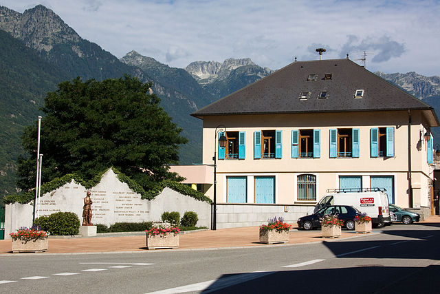
Saint-Étienne-de-Cuines (Saint-Étienne-de-Cuines)

- коммуна во Франции
 Hiking in Saint-Étienne-de-Cuines
Saint-Étienne-de-Cuines, located in the Savoie region of the French Alps, offers beautiful hiking opportunities amidst stunning mountain scenery. The area is characterized by picturesque landscapes, including forests, alpine meadows, and views of the surrounding peaks.
Key Hiking Trails in Saint-Étienne-de-Cuines:
-
Col de la Madeleine: This trail leads you through picturesque landscapes and offers breath-taking views of the mountains and valleys. It's a popular route, especially in spring and summer.
-
Mont Revard Trail: Starting near Saint-Étienne-de-Cuines, this trail gives hikers a chance to experience diverse wildlife and enjoy panoramic views of the surrounding alpine landscapes.
-
Circuit des Lacs de Cottorney: This is a moderate trail that winds around beautiful alpine lakes. It's perfect for a day hike and offers opportunities for photography and wildlife spotting.
Hiking Tips:
- Footwear: Ensure you have good hiking boots with proper grip, as some trails can be rocky and uneven.
- Weather: Check the weather conditions before you head out, as mountain weather can change rapidly.
- Navigation: Carry a map or GPS device, as some trails may not be well-marked.
- Water and Snacks: Bring enough water and snacks to keep your energy up during the hike.
- Local Regulations: Be aware of and respect local regulations, including wildlife protection and designated paths.
Best Time to Hike:
The best times for hiking in the region are typically late spring through early fall (May to October) when the trails are clear of snow and the weather is generally mild.
Overall, hiking in Saint-Étienne-de-Cuines can be a rewarding experience, offering a mix of natural beauty and physical challenge. Whether you're a beginner or an experienced hiker, there are trails suitable for all levels.
- Страна:

- Почтовый код: 73130
- Координаты: 45° 20' 32" N, 6° 17' 30" E


- GPS треки (wikiloc): [Ссылка]
- Площадь: 20.5 кв.км
- Население: 1190
- Википедия английская: wiki(en)
- Википедия национальная: wiki(fr)
- Хранилище Wikidata: Wikidata: Q1157988
- Катеория в википедии: [Ссылка]
- код Freebase: [/m/03npgjd]
- код GeoNames: Альт: [6613972]
- номер SIREN: [217302314]
- код BNF: [15274162f]
- код VIAF: Альт: [239636483]
- код муниципалитета INSEE: 73231
Граничит с регионами:


Saint-Alban-des-Villards
- коммуна во Франции
Hiking in Saint-Alban-des-Villards
Saint-Alban-des-Villards is a charming village located in the French Alps, specifically in the Savoie department of the Auvergne-Rhône-Alpes region. Hiking in this area offers stunning views, diverse landscapes, and a variety of trails suitable for different skill levels. Here are some highlights and tips for hiking in and around Saint-Alban-des-Villards:...
- Страна:
- Почтовый код: 73130
- Координаты: 45° 18' 33" N, 6° 14' 57" E
- GPS треки (wikiloc): [Ссылка]
- Площадь: 24.02 кв.км
- Население: 103

Saint-Avre
- коммуна во Франции
Hiking in Saint-Avre
Saint-Avre is a charming commune located in the Savoie region of the French Alps. Nestled in a picturesque valley, it offers a variety of hiking opportunities that cater to different skill levels and preferences. Here are some key points to consider for hiking in and around Saint-Avre:...
- Страна:
- Почтовый код: 73130
- Координаты: 45° 21' 9" N, 6° 18' 36" E
- GPS треки (wikiloc): [Ссылка]
- Площадь: 3.64 кв.км
- Население: 868


Аллевар
- коммуна во Франции
Hiking in Аллевар
Allevard is a charming town located in the Auvergne-Rhône-Alpes region of France, nestled in the Belledonne mountain range. It's an excellent destination for hikers due to its diverse landscapes, ranging from forests and rivers to rocky peaks....
- Страна:
- Почтовый код: 38580
- Координаты: 45° 23' 37" N, 6° 4' 27" E
- GPS треки (wikiloc): [Ссылка]
- Площадь: 25.63 кв.км
- Население: 4124
- Веб сайт: [Ссылка]


Saint-Rémy-de-Maurienne
- коммуна во Франции
Hiking in Saint-Rémy-de-Maurienne
Saint-Rémy-de-Maurienne is a charming village located in the Savoie region of the French Alps, offering excellent opportunities for hiking enthusiasts. Nestled in the Maurienne Valley, the area is surrounded by stunning alpine scenery, making it an excellent base for outdoor activities....
- Страна:
- Почтовый код: 73660
- Координаты: 45° 23' 31" N, 6° 15' 54" E
- GPS треки (wikiloc): [Ссылка]
- Площадь: 44.26 кв.км
- Население: 1282
- Веб сайт: [Ссылка]

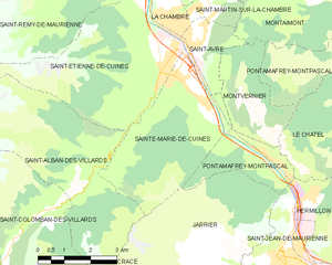
Sainte-Marie-de-Cuines
- коммуна во Франции
Hiking in Sainte-Marie-de-Cuines
Sainte-Marie-de-Cuines is a beautiful destination for hiking enthusiasts, nestled in the Auvergne-Rhône-Alpes region of France, specifically in Savoie. The area offers breathtaking landscapes, from rolling hills to the majestic alpine terrain, making it ideal for various hiking levels. Here are some highlights and tips for hiking in this region:...
- Страна:
- Почтовый код: 73130
- Координаты: 45° 20' 24" N, 6° 18' 6" E
- GPS треки (wikiloc): [Ссылка]
- Площадь: 14.95 кв.км
- Население: 812
- Веб сайт: [Ссылка]

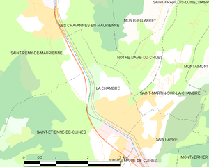
La Chambre
- коммуна во Франции
Hiking in La Chambre
La Chambre is a charming village located in the Savoie region of the French Alps. It’s a great launching point for a variety of hiking trails that cater to different skill levels, from easy walks to more challenging treks. Here are some important aspects of hiking in La Chambre:...
- Страна:
- Почтовый код: 73130
- Координаты: 45° 21' 34" N, 6° 18' 0" E
- GPS треки (wikiloc): [Ссылка]
- Площадь: 3.2 кв.км
- Население: 1148
- Веб сайт: [Ссылка]