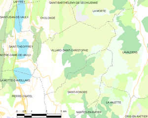
Сент-Оноре (Saint-Honoré, Saint-Honoré)

- коммуна во Франции
 Hiking in Сент-Оноре
Saint-Honoré is a charming village located in the Isère department of the Auvergne-Rhône-Alpes region in southeastern France. It is surrounded by the beautiful Vercors and Chartreuse mountain ranges, making it an excellent base for hiking enthusiasts. Here are some highlights and tips for hiking in and around Saint-Honoré:
Hiking Trails
-
Local Trails: The area around Saint-Honoré offers a network of trails ranging from easy walks to more challenging hikes. Many trails can be accessed directly from the village and lead into the surrounding forests and hills.
-
Vercors Regional Natural Park: A short drive from Saint-Honoré, the Vercors offers a vast array of hiking routes. You can explore stunning limestone cliffs, plateaus, and valleys rich in flora and fauna. Popular hikes include the Route des Crêtes, which provides breathtaking views of the mountains and valleys.
-
Chartreuse Mountains: Just to the east, the Chartreuse range is also a fantastic hiking destination, known for its rugged terrain and dense forests. Trails vary in difficulty, and many lead to picturesque alpine lakes and hidden howes.
Scenic Highlights
- Panoramic Views: Many trails in the area provide stunning panoramic views of the surrounding mountains, especially from higher elevations.
- Alpine Flora and Fauna: The diverse ecosystems in the Vercors and Chartreuse will delight nature lovers. Keep an eye out for unique plant species and wildlife, including chamois and various bird species.
Practical Tips
-
Best Time to Hike: The ideal times for hiking in this region are late spring through early autumn (May to October). However, it's crucial to check trail conditions, especially in early spring and late autumn when snow can still be present in higher altitudes.
-
Equipment: Ensure you have suitable hiking gear, including good hiking boots, a map or GPS device, water, and snacks. For longer hikes, consider bringing a first-aid kit and extra clothing layers.
-
Local Guidance: If you’re unfamiliar with the area, it might be helpful to join a guided hike or visit the local tourist information center for trail maps and advice.
Accommodations
Saint-Honoré offers various accommodation options, from charming guesthouses to camping facilities, making it easy to find a place to stay after a day of hiking.
In summary, hiking in Saint-Honoré and its surrounding regions affords visitors a chance to experience the natural beauty of the French Alps, with trails suitable for all levels of experience. Enjoy your outdoor adventure!
- Страна:

- Почтовый код: 38350
- Координаты: 44° 57' 16" N, 5° 48' 24" E


- GPS треки (wikiloc): [Ссылка]
- Площадь: 14.58 кв.км
- Население: 806
- Википедия русская: wiki(ru)
- Википедия английская: wiki(en)
- Википедия национальная: wiki(fr)
- Хранилище Wikidata: Wikidata: Q1109908
- Катеория в википедии: [Ссылка]
- код Freebase: [/m/03g_0x3]
- код GeoNames: Альт: [6433348]
- номер SIREN: [213803968]
- код BNF: [15258206s]
- код муниципалитета INSEE: 38396
Граничит с регионами:


Ла-Валетт
Hiking in Ла-Валетт
La Valette, located in the stunning landscape of Malta, offers a unique hiking experience characterized by its rich history and scenic views. Here are some points to consider when planning a hike in La Valette:...
- Страна:
- Почтовый код: 38350
- Координаты: 44° 56' 31" N, 5° 51' 23" E
- GPS треки (wikiloc): [Ссылка]
- Высота над уровнем моря: 850 м m
- Площадь: 7.87 кв.км
- Население: 73


Лавальдан
- коммуна во Франции
Hiking in Лавальдан
Lavaldens is a beautiful destination for hiking enthusiasts, located in the stunning region of the Italian Alps, specifically within the Province of Trento. The area is known for its picturesque landscapes, charming villages, and a variety of trails suitable for different levels of hikers. Here are some key points to consider when hiking in Lavaldens:...
- Страна:
- Почтовый код: 38350
- Координаты: 44° 58' 58" N, 5° 53' 15" E
- GPS треки (wikiloc): [Ссылка]
- Площадь: 41.4 кв.км
- Население: 163

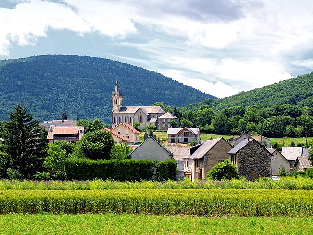
Виллар-Сен-Кристоф
- коммуна во Франции
Hiking in Виллар-Сен-Кристоф
Villard-Saint-Christophe is a picturesque village located in the Isère department of the Auvergne-Rhône-Alpes region in France. It offers a variety of hiking opportunities that showcase the stunning natural scenery of the region, including mountains, lakes, and lush forests....
- Страна:
- Почтовый код: 38119
- Координаты: 44° 58' 44" N, 5° 48' 21" E
- GPS треки (wikiloc): [Ссылка]
- Площадь: 14.22 кв.км
- Население: 408

Пьер-Шатель
- коммуна во Франции
Hiking in Пьер-Шатель
Pierre-Châtel, located in the French Alps in the Isère department, offers a variety of hiking opportunities that showcase stunning natural landscapes and diverse terrains. Here are some key points to consider when hiking in the area:...
- Страна:
- Почтовый код: 38119
- Координаты: 44° 57' 25" N, 5° 46' 34" E
- GPS треки (wikiloc): [Ссылка]
- Площадь: 11.48 кв.км
- Население: 1504
- Веб сайт: [Ссылка]


Нант-ан-Ратье
- коммуна во Франции
Hiking in Нант-ан-Ратье
Nantes-en-Rattier is a charming village located in the Isère department of the Auvergne-Rhône-Alpes region in southeastern France. It offers a serene environment ideal for hiking enthusiasts looking to explore the natural beauty of the French Alps....
- Страна:
- Почтовый код: 38350
- Координаты: 44° 56' 6" N, 5° 49' 36" E
- GPS треки (wikiloc): [Ссылка]
- Высота над уровнем моря: 930 м m
- Площадь: 12.13 кв.км
- Население: 465


Ла-Мюр
- коммуна во Франции
Hiking in Ла-Мюр
La Mure is a charming town situated in the French Alps, known for its breathtaking landscapes and excellent hiking opportunities. Located within the Isère department, it serves as a great starting point for outdoor enthusiasts looking to explore the surrounding mountains and natural parks....
- Страна:
- Почтовый код: 38350
- Координаты: 44° 54' 11" N, 5° 47' 15" E
- GPS треки (wikiloc): [Ссылка]
- Высота над уровнем моря: 886 м m
- Площадь: 8.33 кв.км
- Население: 4992
- Веб сайт: [Ссылка]