Ла-Валетт (La Valette, La Valette)

 Hiking in Ла-Валетт
La Valette, located in the stunning landscape of Malta, offers a unique hiking experience characterized by its rich history and scenic views. Here are some points to consider when planning a hike in La Valette:
Scenic Routes
-
Historical Walks: The city of Valletta itself is a UNESCO World Heritage site, and walking through its historic streets offers a peek into the 16th-century architecture and fortifications. Check out landmarks like St. John's Co-Cathedral and the Grand Master's Palace.
-
Barracca Gardens: The Upper Barracca Gardens provide a beautiful viewpoint over the Grand Harbour and surrounding areas. It's a peaceful place to rest before continuing your hike.
-
Coastal Walks: You can take routes along the coast, enjoying views of the Mediterranean Sea. The nearby areas of Sliema and St. Julian’s are accessible and provide stunning coastal paths.
Hiking Trails
- While specific hiking trails may not be well-marked within Valletta, you can create a loop by combining urban walks with some natural areas outside the city, such as trails leading to the nearby Dingli Cliffs or around the coastal paths.
Difficulty & Preparation
- Most hikes in and around Valletta are relatively easy and suitable for all skill levels. Make sure to wear comfortable shoes since the streets can be uneven and cobbled.
Weather Considerations
- Malta experiences mild winters and hot summers. The best times for hiking are during spring (April to June) and autumn (September to November) when temperatures are more comfortable. Always carry water, wear sunscreen, and be aware of the weather forecast.
Local Tips
- Early mornings or late afternoons are the best times to hike to avoid the heat and enjoy beautiful lighting for photography.
- Engage with local guides or use apps/maps for more detailed information on trails and historical sites to enhance your experience.
In summary, hiking in La Valette allows for a mix of historical exploration and natural beauty, making it a captivating destination for all outdoor enthusiasts. Be sure to plan ahead to enjoy all the sights along the way!
- Страна:

- Почтовый код: 38350
- Координаты: 44° 56' 31" N, 5° 51' 23" E


- GPS треки (wikiloc): [Ссылка]
- Высота над уровнем моря: 850 м m
- Площадь: 7.87 кв.км
- Население: 73
- Википедия русская: wiki(ru)
- Википедия английская: wiki(en)
- Википедия национальная: wiki(fr)
- Хранилище Wikidata: Wikidata: Q1018305
- Катеория в википедии: [Ссылка]
- код Freebase: [/m/03nvkq9]
- код Freebase: [/m/03nvkq9]
- код GeoNames: Альт: [6616680]
- код GeoNames: Альт: [6616680]
- номер SIREN: [213805211]
- номер SIREN: [213805211]
- код BNF: [15258321z]
- код BNF: [15258321z]
- код муниципалитета INSEE: 38521
- код муниципалитета INSEE: 38521
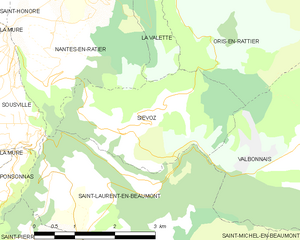
Граничит с регионами:


Лавальдан
- коммуна во Франции
Hiking in Лавальдан
Lavaldens is a beautiful destination for hiking enthusiasts, located in the stunning region of the Italian Alps, specifically within the Province of Trento. The area is known for its picturesque landscapes, charming villages, and a variety of trails suitable for different levels of hikers. Here are some key points to consider when hiking in Lavaldens:...
- Страна:
- Почтовый код: 38350
- Координаты: 44° 58' 58" N, 5° 53' 15" E
- GPS треки (wikiloc): [Ссылка]
- Площадь: 41.4 кв.км
- Население: 163

Сьево
- коммуна во Франции
Hiking in Сьево
Siévoz is a beautiful area in the French Alps, known for its scenic landscapes and hiking opportunities. If you're planning a hiking trip there, here are some key points to consider:...
- Страна:
- Почтовый код: 38350
- Координаты: 44° 54' 12" N, 5° 50' 15" E
- GPS треки (wikiloc): [Ссылка]
- Площадь: 7.37 кв.км
- Население: 136


Ори-ан-Ратье
- коммуна во Франции
Hiking in Ори-ан-Ратье
Oris-en-Rattier is a charming little village in the Isère department in the Auvergne-Rhône-Alpes region of France. Nestled within the stunning landscapes of the French Alps, it offers a range of hiking opportunities for enthusiasts of all levels....
- Страна:
- Почтовый код: 38350
- Координаты: 44° 55' 16" N, 5° 52' 12" E
- GPS треки (wikiloc): [Ссылка]
- Площадь: 18.83 кв.км
- Население: 111


Сент-Оноре
- коммуна во Франции
Hiking in Сент-Оноре
Saint-Honoré is a charming village located in the Isère department of the Auvergne-Rhône-Alpes region in southeastern France. It is surrounded by the beautiful Vercors and Chartreuse mountain ranges, making it an excellent base for hiking enthusiasts. Here are some highlights and tips for hiking in and around Saint-Honoré:...
- Страна:
- Почтовый код: 38350
- Координаты: 44° 57' 16" N, 5° 48' 24" E
- GPS треки (wikiloc): [Ссылка]
- Площадь: 14.58 кв.км
- Население: 806


Нант-ан-Ратье
- коммуна во Франции
Hiking in Нант-ан-Ратье
Nantes-en-Rattier is a charming village located in the Isère department of the Auvergne-Rhône-Alpes region in southeastern France. It offers a serene environment ideal for hiking enthusiasts looking to explore the natural beauty of the French Alps....
- Страна:
- Почтовый код: 38350
- Координаты: 44° 56' 6" N, 5° 49' 36" E
- GPS треки (wikiloc): [Ссылка]
- Высота над уровнем моря: 930 м m
- Площадь: 12.13 кв.км
- Население: 465