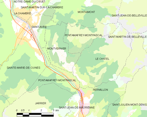
Сен-Жан-де-Морьен (Saint-Jean-de-Maurienne, Saint-Jean-de-Maurienne)

- коммуна во Франции
 Hiking in Сен-Жан-де-Морьен
Saint-Jean-de-Maurienne, located in the Savoie region of the French Alps, is a fantastic destination for hiking enthusiasts, offering a mix of stunning natural landscapes, rich cultural heritage, and a variety of trails suitable for different skill levels.
Trails and Terrain
-
Mont Charvin: This peak presents a moderately challenging hike with rewarding panoramic views at the summit. The trail typically takes about 4-5 hours round trip.
-
Les Aiguilles d'Arves: A more day-long adventure, this area features rugged terrain and offers breathtaking vistas of the peaks. The hike can be technical, so prior hiking experience is recommended.
-
Col du Mollard: An excellent option for families and beginners, this trail offers a gentle ascent and beautiful views of the surrounding valleys. It is an easier hike that usually takes 2-3 hours.
-
Green Pastures and Alpine Lakes: For a scenic and less strenuous experience, consider hikes around the local alpine lakes, where you can enjoy serene water views and lush pastures.
Best Time to Hike
The best seasons for hiking in Saint-Jean-de-Maurienne are late spring to early fall (May to October). During these months, the weather is typically mild, and trails are more accessible. Summer may bring some crowds, but the diverse routes allow for a range of experiences.
Preparation Tips
- Gear: Ensure you have proper hiking boots, weather-appropriate clothing, and a daypack with water, snacks, and a first-aid kit.
- Maps and Navigation: While many trails are well-marked, carrying a map or GPS device can enhance safety, especially on less-traveled paths.
- Local Advice: Don’t hesitate to stop by local tourism offices for the latest trail information and recommendations.
Cultural Aspects
Hiking trips can also be combined with visits to local historical sites, such as the Cathedral of Saint-Jean-de-Maurienne or various museums dedicated to the history of the region. After a day of hiking, enjoy Savoyard cuisine in one of the local restaurants, which often features hearty mountain dishes.
Conclusion
With its diverse trails and incredible landscapes, Saint-Jean-de-Maurienne is a wonderful hiking destination that caters to all levels of hikers. Whether you're seeking challenging ascents or leisurely walks, this area is sure to provide an unforgettable outdoor experience!
- Страна:

- Почтовый код: 73300
- Координаты: 45° 16' 36" N, 6° 20' 42" E


- GPS треки (wikiloc): [Ссылка]
- Площадь: 11.51 кв.км
- Население: 7809
- Веб сайт: http://www.saintjeandemaurienne.fr
- Википедия русская: wiki(ru)
- Википедия английская: wiki(en)
- Википедия национальная: wiki(fr)
- Хранилище Wikidata: Wikidata: Q208860
- Катеория в википедии: [Ссылка]
- код Freebase: [/m/08mt1c]
- код GeoNames: Альт: [2979303]
- номер SIREN: [217302488]
- код BNF: [152741795]
- код VIAF: Альт: [257453901]
- код GND: Альт: [4353409-0]
- код LCNAF: Альт: [n82249299]
- код тезауруса PACTOLS: [pcrtntSXbou7e6]
- место в MusicBrainz: [029b7147-24c3-4ddb-99c7-b060cd0ea4eb]
- код SUDOC: [027237559]
- код Цифрового атласа Римской империи: [193]
- код ISNI: Альт: [0000 0001 2188 1079]
- код муниципалитета INSEE: 73248
Граничит с регионами:

Pontamafrey-Montpascal
- коммуна во Франции
Hiking in Pontamafrey-Montpascal
Pontamafrey-Montpascal is a scenic area in the Savoie region of France, known for its beautiful landscapes, diverse trails, and rich natural flora and fauna. While specific trails can vary, here are some general guidelines and tips for hiking in this region:...
- Страна:
- Почтовый код: 73300
- Координаты: 45° 18' 45" N, 6° 20' 29" E
- GPS треки (wikiloc): [Ссылка]
- Площадь: 11.59 кв.км
- Население: 312
- Веб сайт: [Ссылка]

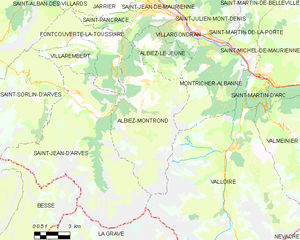
Альбье-Монрон
- коммуна во Франции
Hiking in Альбье-Монрон
Albiez-Montrond is a charming alpine village located in the Savoie region of the French Alps, known for its stunning mountain scenery and outdoor activities, including hiking. Here are some details about hiking in this beautiful area:...
- Страна:
- Почтовый код: 73300
- Координаты: 45° 13' 11" N, 6° 20' 27" E
- GPS треки (wikiloc): [Ссылка]
- Площадь: 48.58 кв.км
- Население: 382
- Веб сайт: [Ссылка]

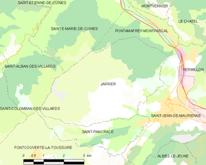
Jarrier
- коммуна во Франции
Hiking in Jarrier
Jarrier is a picturesque village located in the Savoie region of the French Alps, nestled at an altitude of around 1,500 meters. It's an excellent base for hiking enthusiasts, offering stunning views, diverse trails, and a chance to experience the natural beauty of the Alps....
- Страна:
- Почтовый код: 73300
- Координаты: 45° 16' 49" N, 6° 19' 0" E
- GPS треки (wikiloc): [Ссылка]
- Площадь: 17.79 кв.км
- Население: 497
- Веб сайт: [Ссылка]


Hermillon
- коммуна во Франции
Hiking in Hermillon
Hermillon, located in the Savoie region of the French Alps, offers a range of beautiful hiking opportunities amidst stunning mountain scenery. The area is characterized by its picturesque landscapes, charming villages, and a variety of trails that cater to different skill levels....
- Страна:
- Почтовый код: 73300
- Координаты: 45° 17' 54" N, 6° 21' 44" E
- GPS треки (wikiloc): [Ссылка]
- Площадь: 14.06 кв.км
- Население: 572


Фонкуверт-ля-Туссюир
- коммуна во Франции
Hiking in Фонкуверт-ля-Туссюир
Fontcouverte-la-Toussuire is a picturesque village located in the Savoie region of the French Alps, offering a variety of hiking opportunities for outdoor enthusiasts. Whether you’re a beginner or an advanced hiker, the area provides trails that cater to different skill levels, along with stunning mountain scenery, alpine flora, and the chance to spot local wildlife....
- Страна:
- Почтовый код: 73300
- Координаты: 45° 14' 47" N, 6° 18' 9" E
- GPS треки (wikiloc): [Ссылка]
- Площадь: 21.52 кв.км
- Население: 534
- Веб сайт: [Ссылка]
Saint-Pancrace, Savoie
Hiking in Saint-Pancrace, Savoie
Saint-Pancrace, located in the Savoie region of the French Alps, offers a variety of hiking experiences that are suitable for a wide range of skill levels. The breathtaking scenery, characterized by alpine meadows, dense forests, and stunning mountain views, make it an attractive destination for outdoor enthusiasts. Here’s what you need to know about hiking in this area:...
- Страна:
- Почтовый код: 73300
- Координаты: 45° 16' 11" N, 6° 19' 32" E
- GPS треки (wikiloc): [Ссылка]
- Площадь: 5.59 кв.км
- Население: 295

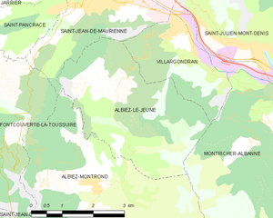
Albiez-le-Jeune
- коммуна во Франции
Hiking in Albiez-le-Jeune
Albiez-le-Jeune is a charming village located in the French Alps, specifically in the Savoie department. This area is perfect for hiking enthusiasts due to its stunning natural landscapes, diverse trails, and mountainous terrain....
- Страна:
- Почтовый код: 73300
- Координаты: 45° 14' 42" N, 6° 21' 6" E
- GPS треки (wikiloc): [Ссылка]
- Площадь: 12.45 кв.км
- Население: 146


Villargondran
- коммуна во Франции
Hiking in Villargondran
Villargondran is a small village located in the Savoie region of the French Alps, near the larger town of Albertville. It offers a beautiful setting for hiking enthusiasts, with stunning mountain landscapes, lush forests, and a variety of trails suitable for different skill levels....
- Страна:
- Почтовый код: 73300
- Координаты: 45° 15' 39" N, 6° 22' 27" E
- GPS треки (wikiloc): [Ссылка]
- Площадь: 6.12 кв.км
- Население: 873