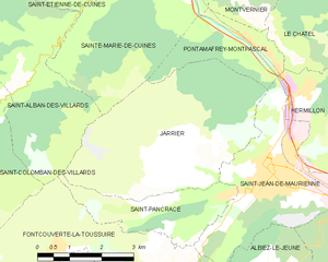
Pontamafrey-Montpascal (Pontamafrey-Montpascal)

- коммуна во Франции
 Hiking in Pontamafrey-Montpascal
Pontamafrey-Montpascal is a scenic area in the Savoie region of France, known for its beautiful landscapes, diverse trails, and rich natural flora and fauna. While specific trails can vary, here are some general guidelines and tips for hiking in this region:
Trails and Scenery
-
Variety of Trails: The area offers a range of hiking trails suitable for different skill levels, from easy walks to more challenging treks. You can explore forested paths, alpine meadows, and stunning viewpoints over the valley.
-
Panoramic Views: Many trails in the area provide breathtaking views of the surrounding mountains, valleys, and sometimes even glacial landscapes. Be sure to check which trails offer the best vistas.
-
Flora and Fauna: The region is rich in biodiversity, so keep an eye out for various plant species, birds, and possibly even wildlife like deer or chamois. Spring and summer are particularly vibrant times to observe wildflowers.
Tips for Hiking
-
Best Time to Hike: Generally, late spring through early autumn (May to October) is the best time for hiking due to favorable weather conditions. However, always check local forecasts before heading out.
-
Preparation: Ensure you have appropriate gear for the conditions, including sturdy hiking boots, weather-resistant clothing, a hat, and sunscreen. A good backpack with water and snacks is also essential.
-
Maps and Navigation: It's advisable to carry a map of the area or use a reliable hiking app for navigation, as some trails may not be well-marked.
-
Safety: Always inform someone of your hiking plans and estimated return time. It’s also wise to hike with a buddy, especially in more remote areas.
-
Leave No Trace: Be respectful of the natural environment. This includes sticking to marked trails, packing out all trash, and not disturbing wildlife.
Local Amenities
- Accommodations: Depending on your preferences, there are various options ranging from campsites to hotels in and around Pontamafrey-Montpascal.
- Guided Tours: If you're new to hiking or the area, consider joining guided hikes that can provide local insights and ensure you don’t miss any highlights.
If you have more specific interests or need additional information, feel free to ask! Enjoy your hiking adventure in Pontamafrey-Montpascal!
- Страна:

- Почтовый код: 73300
- Координаты: 45° 18' 45" N, 6° 20' 29" E


- GPS треки (wikiloc): [Ссылка]
- Площадь: 11.59 кв.км
- Население: 312
- Веб сайт: http://www.pontamafrey-montpascal.fr
- Википедия английская: wiki(en)
- Википедия национальная: wiki(fr)
- Хранилище Wikidata: Wikidata: Q1215085
- Катеория в википедии: [Ссылка]
- код Freebase: [/m/03npfkm]
- код GeoNames: Альт: [6617584]
- номер SIREN: [217302033]
- код BNF: [152741346]
- код муниципалитета INSEE: 73203
Граничит с регионами:


Montaimont
- коммуна во Франции
Hiking in Montaimont
Montaimont is a charming commune in the Savoie department of the Auvergne-Rhône-Alpes region in southeastern France. Nestled in the Alps, it offers stunning natural landscapes and a variety of hiking opportunities, making it an excellent destination for outdoor enthusiasts....
- Страна:
- Почтовый код: 73130
- Координаты: 45° 22' 17" N, 6° 20' 49" E
- GPS треки (wikiloc): [Ссылка]
- Площадь: 28.35 кв.км
- Население: 157
- Веб сайт: [Ссылка]

Jarrier
- коммуна во Франции
Hiking in Jarrier
Jarrier is a picturesque village located in the Savoie region of the French Alps, nestled at an altitude of around 1,500 meters. It's an excellent base for hiking enthusiasts, offering stunning views, diverse trails, and a chance to experience the natural beauty of the Alps....
- Страна:
- Почтовый код: 73300
- Координаты: 45° 16' 49" N, 6° 19' 0" E
- GPS треки (wikiloc): [Ссылка]
- Площадь: 17.79 кв.км
- Население: 497
- Веб сайт: [Ссылка]


Le Châtel
- коммуна во Франции
Hiking in Le Châtel
Le Châtel, a picturesque area located in the French Alps, offers a variety of hiking opportunities suited for different skill levels. It's a less crowded destination compared to some of the more famous Alpine regions, making it a great choice for those seeking tranquility and natural beauty....
- Страна:
- Почтовый код: 73300
- Координаты: 45° 18' 25" N, 6° 21' 32" E
- GPS треки (wikiloc): [Ссылка]
- Площадь: 15.31 кв.км
- Население: 195
- Веб сайт: [Ссылка]


Hermillon
- коммуна во Франции
Hiking in Hermillon
Hermillon, located in the Savoie region of the French Alps, offers a range of beautiful hiking opportunities amidst stunning mountain scenery. The area is characterized by its picturesque landscapes, charming villages, and a variety of trails that cater to different skill levels....
- Страна:
- Почтовый код: 73300
- Координаты: 45° 17' 54" N, 6° 21' 44" E
- GPS треки (wikiloc): [Ссылка]
- Площадь: 14.06 кв.км
- Население: 572


Сен-Жан-де-Морьен
- коммуна во Франции
Hiking in Сен-Жан-де-Морьен
Saint-Jean-de-Maurienne, located in the Savoie region of the French Alps, is a fantastic destination for hiking enthusiasts, offering a mix of stunning natural landscapes, rich cultural heritage, and a variety of trails suitable for different skill levels....
- Страна:
- Почтовый код: 73300
- Координаты: 45° 16' 36" N, 6° 20' 42" E
- GPS треки (wikiloc): [Ссылка]
- Площадь: 11.51 кв.км
- Население: 7809
- Веб сайт: [Ссылка]


Montvernier
- коммуна во Франции
Hiking in Montvernier
Montvernier, located in the Savoie region of the French Alps, is a hidden gem for hikers. The area is renowned for its stunning landscapes, featuring charming alpine villages, lush valleys, and breathtaking mountain views. Here are some key points to consider if you’re planning a hiking trip in Montvernier:...
- Страна:
- Почтовый код: 73300
- Координаты: 45° 19' 17" N, 6° 20' 36" E
- GPS треки (wikiloc): [Ссылка]
- Площадь: 6.68 кв.км
- Население: 223

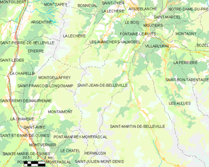
Saint-Jean-de-Belleville
- коммуна во Франции
Hiking in Saint-Jean-de-Belleville
Saint-Jean-de-Belleville is a charming alpine village located in the Savoie region of the French Alps, offering beautiful landscapes and a variety of hiking opportunities. Situated near the Trois Vallées ski area, it serves as a fantastic base for exploring the surrounding mountains, particularly in the warmer months when the snow melts and trails become accessible....
- Страна:
- Почтовый код: 73440
- Координаты: 45° 25' 37" N, 6° 29' 6" E
- GPS треки (wikiloc): [Ссылка]
- Площадь: 59.6 кв.км
- Население: 535
- Веб сайт: [Ссылка]

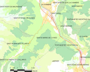
Sainte-Marie-de-Cuines
- коммуна во Франции
Hiking in Sainte-Marie-de-Cuines
Sainte-Marie-de-Cuines is a beautiful destination for hiking enthusiasts, nestled in the Auvergne-Rhône-Alpes region of France, specifically in Savoie. The area offers breathtaking landscapes, from rolling hills to the majestic alpine terrain, making it ideal for various hiking levels. Here are some highlights and tips for hiking in this region:...
- Страна:
- Почтовый код: 73130
- Координаты: 45° 20' 24" N, 6° 18' 6" E
- GPS треки (wikiloc): [Ссылка]
- Площадь: 14.95 кв.км
- Население: 812
- Веб сайт: [Ссылка]