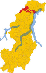
Sant'Antonio (Sant’Antonio TI)

 Hiking in Sant'Antonio
Sant'Antonio, located near Bellinzona in the canton of Ticino, Switzerland, is a fantastic area for hiking, combining beautiful landscapes with cultural and historical elements. Here’s a guide to what you can expect when hiking in this picturesque region.
Scenic Trails
-
Sentiero di Sant'Antonio: This is a well-marked trail that offers stunning views of the surrounding hills, valleys, and the city of Bellinzona. The trail often features varied terrain, including gentle slopes and some more challenging sections, ensuring there’s something for everyone.
-
Monte Carasso Trails: The nearby area of Monte Carasso provides additional hiking opportunities. You can explore trails that lead to viewpoints overlooking the city and the iconic Castles of Bellinzona, which are UNESCO World Heritage sites.
-
Parco delle Gole della Breggia: If you're willing to travel a bit further, this park offers breathtaking landscapes and well-marked trails, where you can enjoy a combination of nature and geological features.
Flora and Fauna
Hiking in this region allows you to experience diverse flora and fauna. Keep an eye out for local wildlife, including various bird species and possibly deer in the more secluded areas. The trail boasts numerous native plants, particularly in spring and summer when the landscape bursts into color.
Historical and Cultural Sites
In addition to natural beauty, the area is rich in cultural history. Don't miss the chance to visit the Castles of Bellinzona, which date back to the Middle Ages and are integral to the region's history.
Practical Tips
- Best Time to Hike: Late spring through early autumn is ideal for hiking, as the weather is pleasantly warm, and trails are more accessible.
- Gear: Wear sturdy hiking boots and bring sufficient water and snacks. A light jacket might be handy, as temperatures can change quickly in the mountains.
- Trail Markings and Maps: Trails are generally well-marked, but it's always a good idea to carry a map or have a GPS-enabled device for navigation, especially if you venture off the main paths.
- Safety: Always inform someone about your hiking plans, especially if you're heading out on less-trafficked routes. Consider the local weather conditions before setting out.
Hiking in Sant'Antonio and the surrounding Bellinzona area offers a perfect blend of physical activity, relaxation, and cultural enrichment, making it an ideal destination for outdoor enthusiasts and nature lovers alike!
- Страна:

- Почтовый код: 6583
- Телефонный код: 091
- Код автомобильного номера: TI
- Координаты: 46° 10' 0" N, 9° 4' 0" E


- GPS треки (wikiloc): [Ссылка]
- Высота над уровнем моря: 822 м m
- Площадь: 33.57 кв.км
- Веб сайт: http://www.santantonio.ch
- Википедия английская: wiki(en)
- Википедия национальная: wiki(de)
- Хранилище Wikidata: Wikidata: Q70313
- Катеория в википедии: [Ссылка]
Граничит с регионами:
Каварнья
- коммуна Италии
Hiking in Каварнья
Cavargna is a picturesque village located in the Italian region of Lombardy, near the border with Switzerland. It's known for its stunning natural landscapes, making it a great destination for hiking enthusiasts. Here are some key points about hiking in Cavargna:...
- Страна:

- Почтовый код: 22010
- Телефонный код: 0344
- Код автомобильного номера: CO
- Координаты: 46° 5' 0" N, 9° 7' 0" E
- GPS треки (wikiloc): [Ссылка]
- Высота над уровнем моря: 1071 м m
- Площадь: 14.98 кв.км
- Население: 212
- Веб сайт: [Ссылка]
Сан-Наццаро-Валь-Каварнья
- коммуна Италии
Hiking in Сан-Наццаро-Валь-Каварнья
San Nazzaro Val Cavargna is a picturesque village located in the province of Como, in the Lombardy region of Italy. Nestled in the Val Cavargna valley, it offers a range of excellent hiking opportunities amid stunning natural landscapes, rich flora, and charming traditional architecture....
- Страна:
- Почтовый код: 22010
- Телефонный код: 0344
- Код автомобильного номера: CO
- Координаты: 46° 5' 0" N, 9° 8' 0" E
- GPS треки (wikiloc): [Ссылка]
- Высота над уровнем моря: 995 м m
- Площадь: 12.99 кв.км
- Население: 302
- Веб сайт: [Ссылка]


Гарцено
- коммуна Италии
Hiking in Гарцено
Garzeno, located in the beautiful Valtellina region of Italy, is a lesser-known yet charming destination for hiking enthusiasts. Nestled in the Lombardy region, it offers stunning landscapes, rich flora and fauna, and a range of trails suitable for various skill levels....
- Страна:
- Почтовый код: 22010
- Телефонный код: 0344
- Код автомобильного номера: CO
- Координаты: 46° 8' 0" N, 9° 15' 0" E
- GPS треки (wikiloc): [Ссылка]
- Высота над уровнем моря: 662 м m
- Площадь: 28.76 кв.км
- Население: 754
- Веб сайт: [Ссылка]

Gravedona ed Uniti
- коммуна Италии
Hiking in Gravedona ed Uniti
Gravedona ed Uniti is a charming town located on the northern shores of Lake Como in Italy, known for its beautiful landscapes and rich history. Hiking in this area offers a variety of trails that cater to different skill levels, providing stunning views of the lake, surrounding mountains, and picturesque villages....
- Страна:
- Почтовый код: 22015
- Телефонный код: 0344
- Код автомобильного номера: CO
- Координаты: 46° 9' 0" N, 9° 18' 0" E
- GPS треки (wikiloc): [Ссылка]
- Высота над уровнем моря: 201 м m
- Площадь: 39.85 кв.км
- Население: 4198
- Веб сайт: [Ссылка]
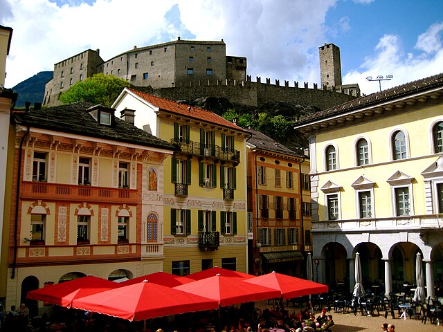
Беллинцона
Hiking in Беллинцона
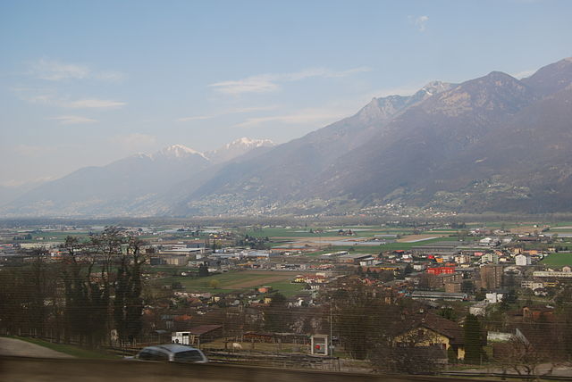
Bellinzona, located in the Ticino region of Switzerland, is an excellent destination for hiking enthusiasts. The area is renowned for its stunning landscapes, rich history, and a network of well-marked hiking trails that cater to various skill levels. Here are some highlights and recommendations for hiking in and around Bellinzona:...
- Страна:
- Почтовый код: 6500
- Телефонный код: 091
- Код автомобильного номера: TI
- Координаты: 46° 11' 44" N, 9° 1' 26" E
- GPS треки (wikiloc): [Ссылка]
- Высота над уровнем моря: 230 м m
- Площадь: 164.96 кв.км
- Население: 42615
- Веб сайт: [Ссылка]


Ровередо
Hiking in Ровередо
Roveredo is a quaint town located in the Mendrisiotto region of Ticino, Switzerland. Surrounded by stunning natural landscapes, it offers several hiking opportunities that cater to a variety of skill levels. Here are some highlights of hiking in Roveredo:...
- Страна:
- Почтовый код: 6535
- Телефонный код: 091
- Код автомобильного номера: GR
- Координаты: 46° 14' 5" N, 9° 7' 33" E
- GPS треки (wikiloc): [Ссылка]
- Высота над уровнем моря: 1239 м m
- Площадь: 38.79 кв.км
- Население: 2483
- Веб сайт: [Ссылка]

Ponte Capriasca
Hiking in Ponte Capriasca
Ponte Capriasca is a charming village located in the Lugano district of southern Switzerland. Surrounded by the picturesque landscapes of the Ticino region, it offers a variety of hiking trails that cater to different skill levels. Here are some key points to consider for hiking in and around Ponte Capriasca:...
- Страна:
- Почтовый код: 6946
- Телефонный код: 091
- Код автомобильного номера: TI
- Координаты: 46° 4' 0" N, 8° 57' 0" E
- GPS треки (wikiloc): [Ссылка]
- Высота над уровнем моря: 447 м m
- Площадь: 6.2 кв.км
- Население: 1889
- Веб сайт: [Ссылка]

Arbedo-Castione
Hiking in Arbedo-Castione
Arbedo-Castione is a picturesque area located in the Canton of Ticino, Switzerland. It's known for its beautiful landscapes, rich history, and a variety of hiking trails suitable for different skill levels. Here are some aspects to consider when hiking in Arbedo-Castione:...
- Страна:
- Телефонный код: 091
- Код автомобильного номера: TI
- Координаты: 46° 13' 0" N, 9° 3' 0" E
- GPS треки (wikiloc): [Ссылка]
- Высота над уровнем моря: 278 м m
- Площадь: 21.52 кв.км
- Население: 5039
- Веб сайт: [Ссылка]
Cadenazzo
Hiking in Cadenazzo
Cadenazzo is a picturesque village located in the Italian-speaking canton of Ticino, Switzerland. It's known for its beautiful landscapes, charming architecture, and proximity to several hiking trails that cater to different skill levels....
- Страна:
- Почтовый код: 6593
- Телефонный код: 091
- Код автомобильного номера: TI
- Координаты: 46° 8' 48" N, 8° 57' 0" E
- GPS треки (wikiloc): [Ссылка]
- Высота над уровнем моря: 296 м m
- Площадь: 8.44 кв.км
- Население: 2932
- Веб сайт: [Ссылка]
Pianezzo
Hiking in Pianezzo
Pianezzo, located near Lugano in the Swiss canton of Ticino, is a lesser-known but beautiful destination for hiking enthusiasts. The area offers a variety of trails that cater to different skill levels, allowing hikers to enjoy breathtaking views of the surrounding mountains and lakes. Here are some key points to consider when hiking in Pianezzo:...
- Страна:
- Почтовый код: 6582
- Телефонный код: 091
- Код автомобильного номера: TI
- Координаты: 46° 10' 0" N, 9° 2' 0" E
- GPS треки (wikiloc): [Ссылка]
- Высота над уровнем моря: 491 м m
- Площадь: 8.03 кв.км
- Веб сайт: [Ссылка]


Monteceneri
Hiking in Monteceneri
Monteceneri, located in the Canton of Ticino in Switzerland, offers a wonderful blend of natural beauty, rich history, and cultural experiences for hikers. Here's what you can expect when hiking in this picturesque region:...
- Страна:
- Почтовый код: 6802
- Телефонный код: 091
- Код автомобильного номера: TI
- Координаты: 46° 7' 30" N, 8° 55' 12" E
- GPS треки (wikiloc): [Ссылка]
- Высота над уровнем моря: 554 м m
- Площадь: 36.9 кв.км
- Население: 4502
- Веб сайт: [Ссылка]