Заттледт (Sattledt, Sattledt)
 Hiking in Заттледт
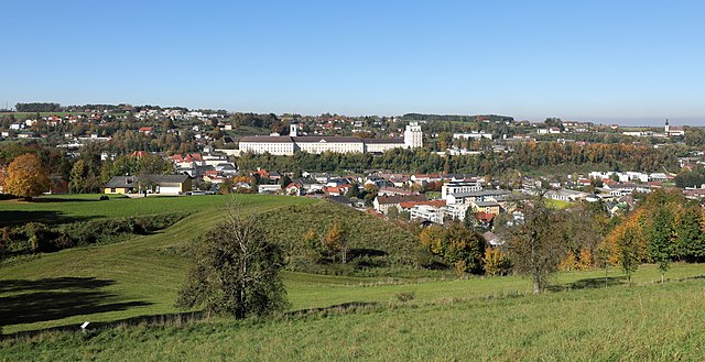
Sattledt is a picturesque village located in Austria, nestled in the region of Upper Austria. While it may not be as widely known as some other hiking destinations in the Alps, it offers access to beautiful landscapes and outdoor experiences.
Hiking Opportunities:
-
Surrounding Nature: The area around Sattledt is characterized by rolling hills, forests, and farmlands. It provides a variety of trails suitable for different skill levels, from leisurely walks to more challenging hikes.
-
Local Trails: There are numerous marked hiking paths that take you through lush meadows and wooded areas. You might find routes that lead to scenic viewpoints, allowing you to enjoy the serenity of the countryside.
-
Nearby Attractions: If you're looking for extended hiking opportunities, consider exploring nearby natural parks or reserves. The Salzkammergut region, for example, is not too far away and features stunning lakes and mountainous terrain, perfect for hiking.
-
Connecting Trails: Sattledt can serve as a base for accessing larger networks of hiking trails, such as the routes leading to the foothills of the Alps. Look for regional hiking guides that can help you navigate and plan your hiking adventures.
Recommendations:
- Maps and Resources: Make sure to have a detailed hiking map or a GPS device, as some trails might not be well-marked.
- Hiking Season: The best time for hiking in this region is typically from late spring to early autumn when the weather is pleasant.
- Safety: Always consider the weather conditions and prepare accordingly. Carry enough water, wear appropriate footwear, and let someone know your plans.
Community and Local Events:
Sattledt often hosts community events, including outdoor festivals or guided hikes, which can be a wonderful way to engage with local culture while enjoying the outdoors.
Overall, hiking in and around Sattledt offers a mix of nature, peace, and opportunities for exploration, making it a worthwhile destination for both novice and experienced hikers.
- Страна:

- Почтовый код: 4642
- Телефонный код: 07244
- Код автомобильного номера: WL
- Координаты: 48° 4' 24" N, 14° 3' 27" E


- GPS треки (wikiloc): [Ссылка]
- Высота над уровнем моря: 400 м m
- Площадь: 22 кв.км
- Население: 2668
- Веб сайт: http://www.sattledt.at/
- Википедия русская: wiki(ru)
- Википедия английская: wiki(en)
- Википедия национальная: wiki(de)
- Хранилище Wikidata: Wikidata: Q664111
- Катеория в википедии: [Ссылка]
- код Freebase: [/m/03gvh1s]
- код GeoNames: Альт: [2766309]
- код VIAF: Альт: [248281078]
- код GND: Альт: [4605617-8]
- код австрийского муниципалитета: [41817]
Граничит с регионами:


Эберстальцелль
Hiking in Эберстальцелль
Eberstalzell is a charming village located in the Innviertel region of Upper Austria. While it may not be as widely known as some hiking destinations, it offers beautiful landscapes and an array of trails suitable for various levels of hikers. Here are some key points to consider when hiking in Eberstalzell:...
- Страна:
- Почтовый код: 4653
- Телефонный код: 0 72 41
- Код автомобильного номера: WL
- Координаты: 48° 2' 41" N, 13° 58' 55" E
- GPS треки (wikiloc): [Ссылка]
- Высота над уровнем моря: 400 м m
- Площадь: 27.6 кв.км
- Население: 2627
- Веб сайт: [Ссылка]

Кремсмюнстер
Hiking in Кремсмюнстер
Kremsmünster, located in the Upper Austria region, offers a variety of scenic hiking opportunities. Nestled at the foot of the Alps, this area boasts beautiful landscapes, rich history, and diverse trails suitable for different skill levels. Here’s an overview of what you might experience while hiking in and around Kremsmünster:...
- Страна:
- Почтовый код: 4550
- Телефонный код: 07583
- Код автомобильного номера: KI
- Координаты: 48° 3' 18" N, 14° 7' 51" E
- GPS треки (wikiloc): [Ссылка]
- Высота над уровнем моря: 384 м m
- Площадь: 42.1 кв.км
- Население: 6585
- Веб сайт: [Ссылка]

Штайнеркирхен-на-Трауне
Hiking in Штайнеркирхен-на-Трауне
Steinerkirchen an der Traun is a picturesque village located in Upper Austria, surrounded by stunning natural landscapes that are ideal for hiking. Here are some highlights for hiking in the region:...
- Страна:
- Почтовый код: 4652
- Телефонный код: 07241
- Код автомобильного номера: WL
- Координаты: 48° 4' 43" N, 13° 57' 30" E
- GPS треки (wikiloc): [Ссылка]
- Высота над уровнем моря: 381 м m
- Площадь: 33.5 кв.км
- Население: 2371
- Веб сайт: [Ссылка]

Зипбахцелль
Hiking in Зипбахцелль
Sipbachzell is a lovely area in Austria that offers a range of hiking opportunities, showcasing the picturesque countryside and natural beauty of the region. Here are some key points to consider if you're planning a hike in and around Sipbachzell:...
- Страна:
- Почтовый код: 4621
- Телефонный код: 07240
- Код автомобильного номера: WL
- Координаты: 48° 5' 53" N, 14° 6' 36" E
- GPS треки (wikiloc): [Ссылка]
- Высота над уровнем моря: 366 м m
- Площадь: 25 кв.км
- Население: 1975
- Веб сайт: [Ссылка]

Штайнхаус
Hiking in Штайнхаус
Steinhaus is a charming village located in the Tyrol region of Austria, surrounded by stunning alpine landscapes, making it a great destination for hiking enthusiasts. Here are some highlights and tips for hiking in the area:...
- Страна:
- Почтовый код: 4641
- Телефонный код: 0 72 42
- Код автомобильного номера: WL
- Координаты: 48° 6' 58" N, 14° 1' 14" E
- GPS треки (wikiloc): [Ссылка]
- Высота над уровнем моря: 378 м m
- Площадь: 25 кв.км
- Население: 2187
- Веб сайт: [Ссылка]

Рид-им-Траункрайс
- сельская община в Австрии, Верхняя Австрия, Кирхдорф-на-Кремсе
Hiking in Рид-им-Траункрайс
Ried im Traunkreis is a lovely area in Austria that offers various hiking opportunities. Nestled in the picturesque landscape of Upper Austria, it is surrounded by beautiful nature, rolling hills, and the Traun River, making it a great destination for outdoor enthusiasts....
- Страна:
- Почтовый код: 4551
- Телефонный код: 07588
- Код автомобильного номера: KI
- Координаты: 48° 1' 31" N, 14° 4' 24" E
- GPS треки (wikiloc): [Ссылка]
- Высота над уровнем моря: 469 м m
- Площадь: 31.1 кв.км
- Население: 2739
- Веб сайт: [Ссылка]