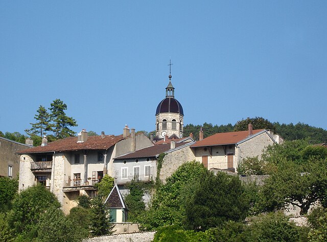
Симандр-сюр-Сюран (Simandre-sur-Suran, Simandre-sur-Suran)
- коммуна во Франции
 Hiking in Симандр-сюр-Сюран
Simandre-sur-Suran is a charming commune located in the Ain department of the Auvergne-Rhône-Alpes region in eastern France. While it may not be as well-known for hiking as some other areas, it offers opportunities to explore the beautiful landscapes and natural surroundings typical of rural France.
Hiking Opportunities:
-
Scenic Nature Trails:
- The region around Simandre-sur-Suran features various trails that allow hikers to enjoy the serene countryside, including rolling hills, forests, and rivers.
-
Local Flora and Fauna:
- As you hike, you’ll encounter diverse plant life and might even spot wildlife such as deer, birds, and small mammals that inhabit this area.
-
Connecting Trails:
- Simandre-sur-Suran is often linked to larger trails in the region. You might consider exploring connecting hiking routes that take you deeper into the Ain department or along the nearby rivers.
-
Cultural Landmarks:
- Along the trails, there may be opportunities to see quaint villages, old farms, and local architecture. Combining nature and culture can enhance your hiking experience.
-
Adjoining Parks and Natural Reserves:
- Consider visiting nearby protected areas or parks where you can find well-marked trails and possibly guided tours. Tenue de la Marne, for instance, offers excellent hiking in a natural setting.
Hiking Tips:
- Map and Guide: Always carry a reliable map and consider using a hiking app to track your route.
- Gear: Wear sturdy hiking boots suitable for varied terrain, and carry weather-appropriate clothing, as conditions can change.
- Hydration and Nutrition: Bring enough water and snacks, especially if you're planning to hike for several hours.
- Local Resources: Check with local tourist offices for information on trails, maps, and recommended routes to explore.
Conclusion:
While Simandre-sur-Suran may not be a major hiking destination, it provides a lovely setting for those looking to enjoy nature and get some fresh air in a peaceful environment. Embrace the slower pace, and take time to appreciate the beauty of the French countryside while hiking in this less-traveled region!
- Страна:

- Почтовый код: 01250
- Координаты: 46° 13' 31" N, 5° 25' 1" E


- GPS треки (wikiloc): [Ссылка]
- Площадь: 16.3 кв.км
- Население: 683
- Веб сайт: http://simandre-sur-suran.wixsite.com
- Википедия русская: wiki(ru)
- Википедия английская: wiki(en)
- Википедия национальная: wiki(fr)
- Хранилище Wikidata: Wikidata: Q777557
- Катеория в википедии: [Ссылка]
- Карты в википедии: [Ссылка]
- код Freebase: [/m/081rtg]
- код Freebase: [/m/081rtg]
- код Freebase: [/m/081rtg]
- код GeoNames: Альт: [2974523]
- код GeoNames: Альт: [2974523]
- код GeoNames: Альт: [2974523]
- номер SIREN: [210104089]
- номер SIREN: [210104089]
- номер SIREN: [210104089]
- код муниципалитета INSEE: 01408
- код муниципалитета INSEE: 01408
- код муниципалитета INSEE: 01408
Граничит с регионами:
Val-Revermont
Hiking in Val-Revermont
Val-Revermont is a picturesque region located in the foothills of the Jura Mountains in eastern France, offering an array of hiking opportunities for all skill levels. Known for its stunning landscapes, lush forests, rolling hills, and charming villages, Val-Revermont provides a beautiful setting for outdoor enthusiasts....
- Страна:
- Почтовый код: 01370
- Координаты: 46° 16' 20" N, 5° 22' 12" E
- GPS треки (wikiloc): [Ссылка]
- Площадь: 45.42 кв.км
- Веб сайт: [Ссылка]

Шаван-сюр-Сюран
- коммуна во Франции
Hiking in Шаван-сюр-Сюран
Chavannes-sur-Suran is a small commune located in the Jura department of France. It's surrounded by beautiful natural landscapes, making it a great destination for hiking enthusiasts. Here are some points of interest for hiking in this area:...
- Страна:
- Почтовый код: 01250
- Координаты: 46° 15' 48" N, 5° 25' 36" E
- GPS треки (wikiloc): [Ссылка]
- Площадь: 21.5 кв.км
- Население: 656

Гран-Коран
- коммуна в департаменте Эн, Франция
Hiking in Гран-Коран
Grand-Corent, located in the French Alps, is a magnificent destination for hikers, offering stunning landscapes and a variety of trails suitable for different skill levels. Here’s a guide to help you make the most of your hiking experience in this picturesque region:...
- Страна:
- Почтовый код: 01250
- Координаты: 46° 11' 57" N, 5° 25' 51" E
- GPS треки (wikiloc): [Ссылка]
- Площадь: 7.13 кв.км
- Население: 177
Треффор-Кюизья
- коммуна во Франции
Hiking in Треффор-Кюизья
Treffort-Cuisiat, located in the Ain department of the Auvergne-Rhône-Alpes region in southeastern France, is an area that offers diverse and beautiful hiking opportunities. The landscape here is characterized by rolling hills, forests, and picturesque views, making it a great spot for both leisurely walks and more challenging hikes....
- Страна:
- Почтовый код: 02220
- Координаты: 46° 16' 17" N, 5° 22' 6" E
- GPS треки (wikiloc): [Ссылка]
- Площадь: 39.41 кв.км
- Население: 1728
- Веб сайт: [Ссылка]

Вильреверсюр
- коммуна во Франции
Hiking in Вильреверсюр
Villereversure is a small commune in the Jura department of France, located in a picturesque area characterized by rolling hills, forests, and panoramic views of the surrounding landscapes. Hiking in this region offers a great escape into nature, with options ranging from easy walks to more challenging trails....
- Страна:
- Почтовый код: 01250
- Координаты: 46° 11' 31" N, 5° 23' 46" E
- GPS треки (wikiloc): [Ссылка]
- Площадь: 17.45 кв.км
- Население: 1262
- Веб сайт: [Ссылка]

Дром
- коммуна во Франции
Hiking in Дром
Drom is a location in Ireland, known for its scenic beauty and diverse hiking opportunities. While it may not be as widely recognized as some of the more famous trails in the country, Drom and its surroundings offer a variety of hiking experiences suitable for different skill levels. Here are some highlights for hiking in the Drom area:...
- Страна:
- Почтовый код: 01250
- Координаты: 46° 13' 3" N, 5° 22' 7" E
- GPS треки (wikiloc): [Ссылка]
- Площадь: 7.78 кв.км
- Население: 219
- Веб сайт: [Ссылка]

Корвесья
- коммуна во Франции
Hiking in Корвесья
Corveissiat is a charming commune located in the Ain department in the Auvergne-Rhône-Alpes region of France. Nestled in the picturesque Jura Mountains, it offers beautiful natural scenery and numerous hiking opportunities for outdoor enthusiasts....
- Страна:
- Почтовый код: 01250
- Координаты: 46° 14' 35" N, 5° 28' 53" E
- GPS треки (wikiloc): [Ссылка]
- Площадь: 22.69 кв.км
- Население: 622
- Веб сайт: [Ссылка]