Сюсвиль (Susville, Susville)

- коммуна во Франции
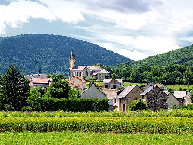
 Hiking in Сюсвиль
Susville, located in the region of Burgundy in France, is surrounded by stunning natural landscapes, making it an excellent destination for hiking enthusiasts. Though it's a smaller town, it offers various trails that cater to different skill levels. Here are some key points to consider for hiking in and around Susville:
-
Natural Attractions: The area is characterized by rolling hills, forests, and the picturesque landscapes of Burgundy. You can expect scenic views, diverse flora and fauna, and possibly even encounters with local wildlife.
-
Trails: While specific trails in Susville may not be as widely known as those in larger national parks, you can find marked hiking paths in the surrounding areas. Trails often include loops of varying lengths and difficulty levels, allowing both casual walkers and experienced hikers to enjoy the outdoors.
-
Local Parks: Nearby natural parks can provide more developed hiking options. These parks often have visitor centers that can provide maps and information about the best trails.
-
Preparation: It’s important to prepare for your hike by checking the weather, packing adequate water and snacks, and wearing appropriate hiking gear. Always inform someone about your hiking plans, especially if venturing onto less-traveled paths.
-
Best Time to Hike: Spring and fall are generally ideal for hiking in Burgundy, as the weather is mild, and the scenery is particularly beautiful with blooming flowers or autumn foliage. Summer can be warm, while winter might limit accessible trails.
-
Cultural Experience: As you hike, take the opportunity to immerse yourself in the local culture. You might encounter charming villages, vineyards, or historical landmarks along your route. Don't hesitate to take breaks at local cafés or farms to experience the regional cuisine.
If you plan to hike in Susville, make sure to research specific trails and consider local regulations or guidelines. Happy hiking!
- Страна:

- Почтовый код: 38350
- Координаты: 44° 54' 57" N, 5° 46' 49" E


- GPS треки (wikiloc): [Ссылка]
- Высота над уровнем моря: 910 м m
- Площадь: 9.91 кв.км
- Население: 1314
- Веб сайт: http://susvilleinfo.canalblog.com
- Википедия русская: wiki(ru)
- Википедия английская: wiki(en)
- Википедия национальная: wiki(fr)
- Хранилище Wikidata: Wikidata: Q1154579
- Катеория в википедии: [Ссылка]
- код Freebase: [/m/03g_0vr]
- код GeoNames: Альт: [6616678]
- номер SIREN: [213804990]
- код BNF: [15258301b]
- код муниципалитета INSEE: 38499
Граничит с регионами:

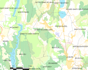
Ла-Мотт-д'Авеян
- коммуна во Франции
Hiking in Ла-Мотт-д'Авеян
La Motte-d'Aveillans is a charming village located in the French Alps, offering a variety of hiking opportunities suitable for different levels of experience. The scenic beauty of the area makes it a popular destination for nature lovers and outdoor enthusiasts. Here are some highlights of hiking in La Motte-d'Aveillans:...
- Страна:
- Почтовый код: 38770
- Координаты: 44° 57' 40" N, 5° 44' 42" E
- GPS треки (wikiloc): [Ссылка]
- Площадь: 9.78 кв.км
- Население: 1748


Прюньер
Hiking in Прюньер
Prunières, located in the Isère department in the Auvergne-Rhône-Alpes region of France, offers a variety of hiking opportunities that allow hikers to enjoy beautiful landscapes, lush forests, and alpine vistas. Here are some highlights about hiking in and around Prunières:...
- Страна:
- Почтовый код: 38350
- Координаты: 44° 53' 35" N, 5° 45' 47" E
- GPS треки (wikiloc): [Ссылка]
- Площадь: 8.2 кв.км
- Население: 365

Пьер-Шатель
- коммуна во Франции
Hiking in Пьер-Шатель
Pierre-Châtel, located in the French Alps in the Isère department, offers a variety of hiking opportunities that showcase stunning natural landscapes and diverse terrains. Here are some key points to consider when hiking in the area:...
- Страна:
- Почтовый код: 38119
- Координаты: 44° 57' 25" N, 5° 46' 34" E
- GPS треки (wikiloc): [Ссылка]
- Площадь: 11.48 кв.км
- Население: 1504
- Веб сайт: [Ссылка]


Ла-Мюр
- коммуна во Франции
Hiking in Ла-Мюр
La Mure is a charming town situated in the French Alps, known for its breathtaking landscapes and excellent hiking opportunities. Located within the Isère department, it serves as a great starting point for outdoor enthusiasts looking to explore the surrounding mountains and natural parks....
- Страна:
- Почтовый код: 38350
- Координаты: 44° 54' 11" N, 5° 47' 15" E
- GPS треки (wikiloc): [Ссылка]
- Высота над уровнем моря: 886 м m
- Площадь: 8.33 кв.км
- Население: 4992
- Веб сайт: [Ссылка]