.JPG)
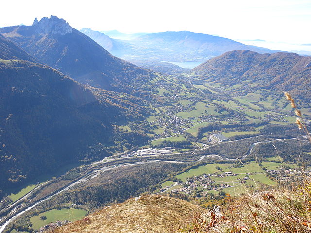
Тон (Thônes, Thônes)

- коммуна во Франции
 Hiking in Тон
Thônes is a charming town located in the Haute-Savoie region of the French Alps. It's a great base for hiking enthusiasts, offering stunning mountain scenery, diverse trails, and access to both the Aravis mountain range and the surrounding areas. Here are some highlights about hiking in Thônes:
Trails and Routes:
-
Col de la Croix-Fry: This is a popular starting point for various hikes. From here, you can access trails leading to stunning viewpoints or deeper into the Aravis mountains.
-
Tête de l'Arclusaz: A moderately challenging hike that offers a rewarding panoramic view of the surrounding mountains, including Mont Blanc, on clear days.
-
Montagne de Semnoz: Located a bit further away, this mountain offers a network of hiking trails suitable for all levels. The ascent provides beautiful views of Lake Annecy and the surrounding landscapes.
-
Les Chalets de la Frasse: This is a family-friendly hike that leads to traditional Alpine chalets. It’s a great way to experience the local culture while enjoying nature.
-
Lac de Thônes: For a more relaxed outing, consider a walk around this picturesque lake. The surrounding area has trails suitable for families and those looking for a more leisurely stroll.
Tips for Hiking in Thônes:
- Best Time to Hike: The best time for hiking is typically late spring to early autumn (May to October), when the weather is milder and trails are accessible.
- Gear and Preparation: Ensure you have appropriate hiking gear, including sturdy boots, weather-appropriate clothing, and a map or GPS device.
- Local Information: Visit local tourist offices for maps, trail conditions, and recommendations tailored to your skill level.
- Respect Nature: Follow Leave No Trace principles to preserve the natural beauty of the area. Take all trash with you and stay on marked trails.
Other Activities:
In addition to hiking, Thônes offers opportunities for other outdoor activities like mountain biking, paragliding, and in winter, skiing and snowshoeing in the surrounding mountains.
Cultural Insights:
Thônes is known for its rich heritage, including its local cheeses like Reblochon. Consider sampling local cuisine after a day of hiking to enhance your alpine experience.
Enjoy your hiking adventures in Thônes! Always stay safe and be prepared for changing weather conditions, especially in mountainous areas.
- Страна:

- Почтовый код: 74230
- Координаты: 45° 52' 56" N, 6° 19' 32" E


- GPS треки (wikiloc): [Ссылка]
- Площадь: 52.33 кв.км
- Население: 6549
- Веб сайт: http://www.mairie-thones.fr
- Википедия английская: wiki(en)
- Википедия национальная: wiki(fr)
- Хранилище Wikidata: Wikidata: Q840190
- Катеория в википедии: [Ссылка]
- код Freebase: [/m/03ntz52]
- код GeoNames: Альт: [2972749]
- номер SIREN: [217402809]
- код BNF: [15274533z]
- код VIAF: Альт: [137045629]
- код LCNAF: Альт: [n87116967]
- код муниципалитета INSEE: 74280
Граничит с регионами:


Entremont, Haute-Savoie
- коммуна во Франции
Hiking in Entremont, Haute-Savoie
Entremont, located in the Haute-Savoie region of France, is a beautiful area known for its stunning landscapes and excellent hiking opportunities. Nestled in the French Alps, Entremont offers a variety of trails suitable for hikers of all levels, from beginners to experienced adventurers....
- Страна:
- Почтовый код: 74130
- Координаты: 45° 57' 24" N, 6° 23' 20" E
- GPS треки (wikiloc): [Ссылка]
- Площадь: 18.35 кв.км
- Население: 664
- Веб сайт: [Ссылка]


Ла Клюза
- коммуна во Франции
Hiking in Ла Клюза
La Clusaz is a charming alpine village located in the French Alps, known for its skiing in the winter and its stunning hiking trails in the summer. It’s a popular destination for outdoor enthusiasts, offering a variety of hiking experiences suitable for all levels of hikers....
- Страна:
- Почтовый код: 74220
- Координаты: 45° 54' 15" N, 6° 25' 23" E
- GPS треки (wikiloc): [Ссылка]
- Площадь: 40.62 кв.км
- Население: 1770
- Веб сайт: [Ссылка]

Alex
- коммуна во Франции
Hiking in Alex
Alex is a charming village located in the Haute-Savoie region of the Auvergne-Rhône-Alpes in southeastern France. Nestled in the beautiful French Alps, it serves as a great starting point for various hiking adventures, offering stunning views and diverse landscapes. Here are some highlights about hiking in and around Alex:...
- Страна:
- Почтовый код: 74290
- Координаты: 45° 53' 20" N, 6° 14' 18" E
- GPS треки (wikiloc): [Ссылка]
- Площадь: 17.02 кв.км
- Население: 1031


La Balme-de-Thuy
- коммуна во Франции
Hiking in La Balme-de-Thuy
La Balme-de-Thuy is a picturesque village located in the Haute-Savoie region of the French Alps, known for its beautiful landscapes and outdoor activities, particularly hiking. Here are some key points about hiking in La Balme-de-Thuy:...
- Страна:
- Почтовый код: 74230
- Координаты: 45° 54' 2" N, 6° 16' 34" E
- GPS треки (wikiloc): [Ссылка]
- Площадь: 17.79 кв.км
- Население: 444


Les Clefs
- коммуна во Франции
Hiking in Les Clefs
Les Clefs is a charming village located in the Haute-Savoie region of the French Alps, making it a great destination for hiking enthusiasts. The area offers stunning alpine scenery, lush forests, and various trails suitable for different skill levels. Here are some highlights for hiking in Les Clefs:...
- Страна:
- Почтовый код: 74230
- Координаты: 45° 51' 40" N, 6° 19' 41" E
- GPS треки (wikiloc): [Ссылка]
- Площадь: 18.47 кв.км
- Население: 628


Manigod
- коммуна во Франции
Hiking in Manigod
Manigod is a picturesque alpine village located in the French Alps, specifically in the Haute-Savoie region. It’s well-known for its stunning landscapes, offering breathtaking views of the surrounding mountains, lush greenery, and vibrant meadows. Here are some important aspects to consider when hiking in Manigod:...
- Страна:
- Почтовый код: 74230
- Координаты: 45° 51' 39" N, 6° 22' 12" E
- GPS треки (wikiloc): [Ссылка]
- Площадь: 44.12 кв.км
- Население: 1005
- Веб сайт: [Ссылка]


Les Villards-sur-Thônes
- коммуна во Франции
Hiking in Les Villards-sur-Thônes
Les Villards-sur-Thônes is a charming village situated in the Haute-Savoie region of the French Alps. It's an excellent base for hiking enthusiasts due to its scenic landscapes, varied terrain, and proximity to the Aravis Mountain range....
- Страна:
- Почтовый код: 74230
- Координаты: 45° 54' 26" N, 6° 21' 57" E
- GPS треки (wikiloc): [Ссылка]
- Площадь: 13.32 кв.км
- Население: 1038