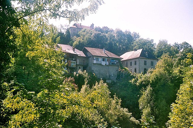
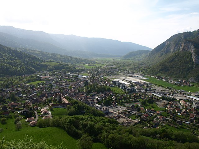
Анси (arrondissement of Annecy, arrondissement d'Annecy)

- округ Франции
 Hiking in Анси
The Arrondissement of Annecy, located in the Haute-Savoie region of the French Alps, is a fantastic destination for hiking enthusiasts. Known for its breathtaking landscapes, picturesque lakes, and charming villages, the area offers a variety of hiking trails suitable for all levels of hikers. Here are some highlights:
Popular Hiking Trails
-
Lake Annecy Circuit:
- A stunning trail that follows the perimeter of Lake Annecy, offering views of crystal-clear waters and surrounding mountains. The path is mostly flat and suitable for families.
-
Tournette:
- A more challenging hike that leads to the summit of La Tournette, the highest peak overlooking Lake Annecy. The trail offers panoramic views and is around 15 km long with a significant elevation gain.
-
Semnoz:
- A range of trails suitable for hikers of all levels. The Semnoz area has multiple routes through forests, meadows, and viewpoints. It’s particularly beautiful in the spring and summer when wildflowers bloom.
-
Les Dents de Lanfon:
- A challenging hike that provides incredible views over Lake Annecy and the surrounding mountains. The trail is steep in sections and requires a good level of fitness but rewards with breathtaking vistas.
-
Col de la Forclaz:
- Offers several hiking options and is famous for its views of Lake Annecy. Hikes can vary in difficulty and length, making it a versatile starting point for exploring the area.
Best Times to Hike
- Spring (April to June): Ideal for witnessing wildflowers and lush greenery. The weather is generally mild, though some higher trails may still have snow.
- Summer (July to August): Perfect for longer hikes, with warm temperatures. Popular trails may be busier during this time.
- Autumn (September to October): Offers stunning fall foliage and cooler temperatures, making it a great time to hike without the summer crowds.
Preparation Tips
- Gear: Make sure to wear sturdy hiking boots and dress in layers. Weather can change quickly in the mountains, so be prepared for varying conditions.
- Hydration and Snacks: Bring enough water and snacks to keep your energy up, especially on longer hikes.
- Local Regulations: Be aware of local regulations and carry a map or use a GPS app to stay on the trails.
Safety Considerations
- Check the weather forecast before heading out, as conditions can change quickly in the mountains.
- Ensure you have adequate experience for the trail you choose, especially on more challenging routes.
Whether you’re looking for leisurely walks by the lake or challenging ascents in the Alps, the Arrondissement of Annecy offers a diverse range of hiking experiences amidst stunning natural beauty. Happy hiking!
- Страна:

- Столица: Анси
- Координаты: 45° 55' 0" N, 6° 10' 0" E


- GPS треки (wikiloc): [Ссылка]
- Площадь: 1259.2 кв.км
- Население: 279623
- Википедия русская: wiki(ru)
- Википедия английская: wiki(en)
- Википедия национальная: wiki(fr)
- Хранилище Wikidata: Wikidata: Q700433
- код Freebase: [/m/095hq2]
- код GeoNames: Альт: [3037542]
- код округа INSEE: [741]
- код GNS: -1407761
Включает регионы:


canton of Rumilly
Hiking in canton of Rumilly
The Canton of Rumilly, located in the Haute-Savoie department in the Auvergne-Rhône-Alpes region of France, offers a variety of scenic hiking opportunities. This area is characterized by its stunning landscapes, including rolling hills, forests, lakes, and views of the surrounding mountains, including the Bauges massif and the Chartreuse mountains....
- Страна:
- Столица: Rumilly
- Координаты: 45° 53' 31" N, 5° 57' 2" E
- GPS треки (wikiloc): [Ссылка]
- Население: 44297

Canton of Thorens-Glières
Hiking in Canton of Thorens-Glières
Canton de Thorens-Glières, located in the Haute-Savoie region of the French Alps, offers a stunning backdrop for hiking enthusiasts. Surrounded by rugged mountains, lush forests, and picturesque alpine meadows, this area is ideal for both casual walkers and experienced trekkers....
- Страна:
- Столица: Thorens-Glières
- Координаты: 45° 59' 37" N, 6° 12' 22" E
- GPS треки (wikiloc): [Ссылка]
Canton of Alby-sur-Chéran
Hiking in Canton of Alby-sur-Chéran
Canton d'Alby-sur-Chéran, located in the Savoie region of southeastern France, offers a variety of picturesque hiking opportunities for outdoor enthusiasts. Nestled between the beautiful landscapes of the French Alps and Lake Bourget, this area is rich in natural beauty and cultural heritage. Here are some highlights for hiking in this region:...
- Страна:
- Столица: Alby-sur-Chéran
- Координаты: 45° 47' 58" N, 6° 1' 46" E
- GPS треки (wikiloc): [Ссылка]
Canton of Annecy-Nord-Est
Hiking in Canton of Annecy-Nord-Est
Canton d'Annecy-Nord-Est, located in the region of Auvergne-Rhône-Alpes in France, is a fantastic destination for hiking enthusiasts. The area is known for its stunning landscapes, which include the beautiful Lake Annecy, majestic mountains, and lush greenery. Here are some highlights for hiking in this region:...
- Страна:
- Координаты: 45° 54' 0" N, 6° 7' 0" E
- GPS треки (wikiloc): [Ссылка]

canton of Annecy-le-Vieux
Hiking in canton of Annecy-le-Vieux
The Canton of Annecy-le-Vieux, located in the Haute-Savoie region of France, is a picturesque area known for its stunning landscapes, including the beautiful Lake Annecy and the surrounding mountains. Hiking in this region offers a range of trails suitable for various skill levels, making it a fantastic destination for both beginners and experienced hikers....
- Страна:
- Столица: Annecy-le-Vieux
- Координаты: 45° 55' 20" N, 6° 10' 22" E
- GPS треки (wikiloc): [Ссылка]
- Население: 53160
canton of Faverges
Hiking in canton of Faverges
Hiking in the Canton of Faverges, located in the Haute-Savoie department of the Auvergne-Rhône-Alpes region in southeastern France, offers spectacular views and beautiful landscapes. The canton is nestled near the Alps and the shores of Lake Annecy, providing a diverse range of hiking trails suitable for various skill levels....
- Страна:
- Столица: Фаверж
- Координаты: 45° 44' 47" N, 6° 17' 43" E
- GPS треки (wikiloc): [Ссылка]
- Население: 40816

Сейно
- кантон Франции
Hiking in Сейно
The Canton of Seynod, located in the Haute-Savoie region of France, is a fantastic destination for hiking enthusiasts. Though Seynod itself is a commune, it serves as a gateway to the surrounding natural beauty of the French Alps, offering a variety of trails suitable for all levels of hikers....
- Страна:
- Столица: Сейно
- Координаты: 45° 49' 59" N, 6° 10' 1" E
- GPS треки (wikiloc): [Ссылка]
- Население: 50583

Тон
- кантон Франции
Hiking in Тон
Canton de Thônes, located in the Haute-Savoie region of the French Alps, offers a splendid array of hiking opportunities. The region is characterized by its stunning alpine scenery, lush valleys, and charming mountain villages, making it a perfect destination for outdoor enthusiasts and nature lovers....
Canton of Annecy-Centre
Hiking in Canton of Annecy-Centre
Canton d'Annecy-Centre, located in the Haute-Savoie region of France, offers a stunning mix of lakes, mountains, and picturesque villages that make it an excellent destination for hiking enthusiasts. Here are some highlights and tips for hiking in this area:...
- Страна:
- Координаты: 45° 54' 0" N, 6° 7' 0" E
- GPS треки (wikiloc): [Ссылка]
canton of Annecy-Nord-Ouest
Hiking in canton of Annecy-Nord-Ouest
Canton d'Annecy-Nord-Ouest is a beautiful region in the Haute-Savoie department of the Auvergne-Rhône-Alpes in France. Nestled near the shores of Lake Annecy and surrounded by the picturesque French Alps, this area is a fantastic spot for hiking enthusiasts of all levels....
- Страна:
- Координаты: 45° 56' 44" N, 6° 3' 24" E
- GPS треки (wikiloc): [Ссылка]