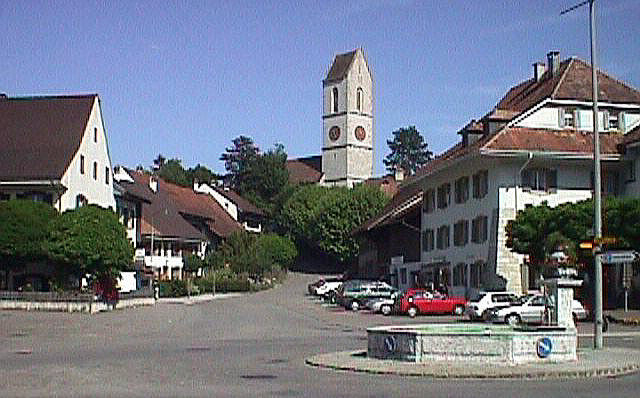
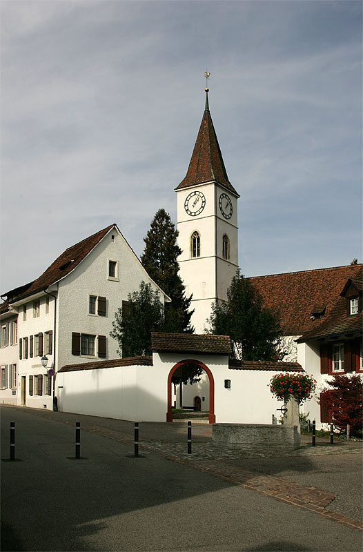
Тюрнен (Thürnen, Thürnen)

 Hiking in Тюрнен
Thürnen, a picturesque village located in the German state of Baden-Württemberg, offers a range of hiking opportunities amidst beautiful natural landscapes. While 'Thürnen' might not be as renowned as some larger hiking destinations, it provides a peaceful and scenic environment for hikers looking to explore the Swabian Jura region.
Key Hiking Points in Thürnen:
-
Scenic Trails: The area around Thürnen features well-marked hiking trails that often lead through lush forests, rolling hills, and open fields. Popular routes usually include a mix of moderate and easy trails, making it suitable for hikers of various skill levels.
-
Nature and Wildlife: The region is rich in biodiversity. Keep an eye out for local wildlife such as deer, various bird species, and unique flora along the trails.
-
Historical Landmarks: As you hike, you may encounter historical sites, including old churches and traditional Swabian architecture, which add to the cultural experience.
-
Local Recommendations: Consider seeking advice from local hiking clubs or visitor centers for recommendations on the best trails and hidden gems in the area.
-
Nearby Regions: If you're looking to extend your hike, consider exploring nearby natural parks or regions such as the Swabian Jura (Schwäbische Alb), which is known for its stunning landscapes and extensive network of hiking paths.
Tips for Hiking in Thürnen:
- Safety: Always carry a map or have a GPS device, as some trails may not be well-marked.
- Gear: Wear appropriate footwear and clothing, considering the weather and trail conditions.
- Water and Snacks: Bring enough water and light snacks to keep your energy levels up during your hike.
- Respect Nature: Follow Leave No Trace principles to preserve the beauty of the area.
Overall, hiking in and around Thürnen can offer a serene experience enriched by nature, culture, and exercise. Always check local sources for the latest trail conditions and recommendations before heading out. Happy hiking!
- Страна:

- Почтовый код: 4441
- Телефонный код: 061
- Код автомобильного номера: BL
- Координаты: 47° 27' 26" N, 7° 49' 49" E


- GPS треки (wikiloc): [Ссылка]
- Высота над уровнем моря: 409 м m
- Площадь: 2.25 кв.км
- Население: 1403
- Веб сайт: http://www.thuernen.ch
- Википедия русская: wiki(ru)
- Википедия английская: wiki(en)
- Википедия национальная: wiki(de)
- Хранилище Wikidata: Wikidata: Q67926
- Катеория в википедии: [Ссылка]
- код Freebase: [/m/0g81_s]
- код GeoNames: Альт: [8533586]
- код VIAF: Альт: [248296272]
- ID отношения в OpenStreetMap: [1683715]
- идентификатор HDS: [1239]
- код швейцарского муниципалитета: [2864]
Граничит с регионами:

Гельтеркинден
Hiking in Гельтеркинден
Gelterkinden, located in the canton of Basel-Landschaft in Switzerland, is an excellent destination for hiking enthusiasts. The region is characterized by picturesque landscapes, diverse terrain, and a mix of forests, hills, and meadows. Here are some key points to consider when hiking in Gelterkinden:...
- Страна:
- Почтовый код: 4460
- Телефонный код: 061
- Код автомобильного номера: BL
- Координаты: 47° 27' 55" N, 7° 51' 10" E
- GPS треки (wikiloc): [Ссылка]
- Высота над уровнем моря: 458 м m
- Площадь: 9.79 кв.км
- Население: 6095
- Веб сайт: [Ссылка]
Цунцген
Hiking in Цунцген
Zunzgen is a small municipality located in the canton of Basel-Landschaft in Switzerland. While it may not be one of the most widely known hiking destinations, the surrounding region offers beautiful landscapes and diverse trails that can suit various skill levels. Here are some key points to consider if you're planning to hike in or around Zunzgen:...
- Страна:
- Почтовый код: 4455
- Телефонный код: 061
- Код автомобильного номера: BL
- Координаты: 47° 26' 42" N, 7° 47' 55" E
- GPS треки (wikiloc): [Ссылка]
- Высота над уровнем моря: 472 м m
- Площадь: 6.87 кв.км
- Население: 2502
- Веб сайт: [Ссылка]

Зиссах
Hiking in Зиссах
Sissach is a picturesque municipality located in the Baselland region of Switzerland, surrounded by beautiful landscapes and natural beauty, making it an excellent destination for hiking enthusiasts. Here’s what you should know about hiking in Sissach:...
- Страна:
- Почтовый код: 4450
- Телефонный код: 061
- Код автомобильного номера: BL
- Координаты: 47° 28' 0" N, 7° 49' 0" E
- GPS треки (wikiloc): [Ссылка]
- Высота над уровнем моря: 372 м m
- Площадь: 8.87 кв.км
- Население: 6666
- Веб сайт: [Ссылка]


Бёктен
Hiking in Бёктен
Böckten is a charming municipality located in the canton of Basel-Landschaft in Switzerland. The area around Böckten offers beautiful landscapes, lush nature, and a variety of hiking trails suitable for different skill levels....
- Страна:
- Почтовый код: 4461
- Телефонный код: 061
- Код автомобильного номера: BL
- Координаты: 47° 27' 45" N, 7° 50' 8" E
- GPS треки (wikiloc): [Ссылка]
- Высота над уровнем моря: 473 м m
- Площадь: 2.28 кв.км
- Население: 804
- Веб сайт: [Ссылка]
Дипфлинген
Hiking in Дипфлинген
Diepflingen, located in the beautiful region of Switzerland, is a fantastic destination for hiking enthusiasts. Nestled near the Swiss-German border, the area is characterized by stunning landscapes, rolling hills, lush forests, and charming countryside. Here are some key highlights for hiking in Diepflingen:...
- Страна:
- Почтовый код: 4442
- Телефонный код: 061
- Код автомобильного номера: BL
- Координаты: 47° 26' 42" N, 7° 50' 25" E
- GPS треки (wikiloc): [Ссылка]
- Высота над уровнем моря: 412 м m
- Площадь: 1.44 кв.км
- Население: 738
- Веб сайт: [Ссылка]