Гельтеркинден (Gelterkinden, Gelterkinden)

 Hiking in Гельтеркинден
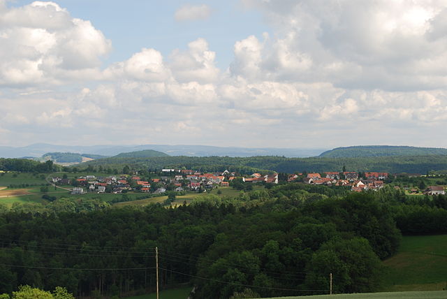
Gelterkinden, located in the canton of Basel-Landschaft in Switzerland, is an excellent destination for hiking enthusiasts. The region is characterized by picturesque landscapes, diverse terrain, and a mix of forests, hills, and meadows. Here are some key points to consider when hiking in Gelterkinden:
Hiking Trails
- Variety of Trails: There are various hiking trails ranging from easy to moderate difficulty, making it suitable for families, beginners, and experienced hikers alike.
- Scenic Routes: Many trails offer stunning views of the surrounding countryside, hills, and occasionally even glimpses of the nearby Jura mountain range.
- Marked Trails: The trails are usually well-marked with Swiss hiking signs, making it easy to navigate.
Highlights
- Natural Beauty: The area is rich in natural beauty, featuring lush forests, rolling hills, and vibrant wildflower meadows, particularly during the spring and summer months.
- Wildlife: Keep an eye out for local wildlife such as deer, various bird species, and unique flora that thrives in the region.
- Cultural Sites: There may be historical sites or quaint villages along the trails, adding an interesting cultural aspect to your hiking experience.
Tips for Hiking in Gelterkinden
- Weather: Always check the weather before heading out, as conditions can change rapidly in the region.
- Gear: Wear appropriate hiking footwear and attire suited for the terrain and weather. Carry a backpack with water, snacks, and first-aid essentials.
- Maps and Guides: While the trails are generally well-marked, it can be helpful to have a map or a hiking app on your phone for additional guidance.
- Respect Nature: Stay on designated paths to preserve the natural environment, and always follow local guidelines and regulations.
Access and Transportation
Gelterkinden is accessible by public transport, with train and bus services connecting to larger cities like Basel and Liestal. For hikers driving in, parking areas are typically available at trailheads.
Conclusion
Hiking in Gelterkinden provides a refreshing opportunity to experience the beauty of nature and enjoy the tranquility of the Swiss countryside. Whether you're looking for a short day hike or planning a longer trek, Gelterkinden is worth exploring.
- Страна:

- Почтовый код: 4460
- Телефонный код: 061
- Код автомобильного номера: BL
- Координаты: 47° 27' 55" N, 7° 51' 10" E


- GPS треки (wikiloc): [Ссылка]
- Высота над уровнем моря: 458 м m
- Площадь: 9.79 кв.км
- Население: 6095
- Веб сайт: http://www.gelterkinden.ch
- Википедия русская: wiki(ru)
- Википедия английская: wiki(en)
- Википедия национальная: wiki(de)
- Хранилище Wikidata: Wikidata: Q65936
- Катеория в википедии: [Ссылка]
- код Freebase: [/m/0g815j]
- код GeoNames: Альт: [7285897]
- код VIAF: Альт: [245658042]
- ID отношения в OpenStreetMap: [1683649]
- место в MusicBrainz: [2be18e3d-80c7-4bd7-b393-4912cc06f1d3]
- идентификатор HDS: [1222]
- EMLO location ID: [77857eb2-00a3-4c1e-b409-eed84d4655ea]
- код швейцарского муниципалитета: [2846]
- код Цифрового атласа Римской империи: [38829]
Граничит с регионами:


Бёктен
Hiking in Бёктен
Böckten is a charming municipality located in the canton of Basel-Landschaft in Switzerland. The area around Böckten offers beautiful landscapes, lush nature, and a variety of hiking trails suitable for different skill levels....
- Страна:
- Почтовый код: 4461
- Телефонный код: 061
- Код автомобильного номера: BL
- Координаты: 47° 27' 45" N, 7° 50' 8" E
- GPS треки (wikiloc): [Ссылка]
- Высота над уровнем моря: 473 м m
- Площадь: 2.28 кв.км
- Население: 804
- Веб сайт: [Ссылка]
Текнау
Hiking in Текнау
Tecknau is a picturesque village located in the Baselland region of Switzerland, surrounded by beautiful landscapes and scenic trails perfect for hiking enthusiasts. Here are some highlights for a hiking experience in and around Tecknau:...
- Страна:
- Почтовый код: 4492
- Телефонный код: 061
- Код автомобильного номера: BL
- Координаты: 47° 26' 43" N, 7° 53' 23" E
- GPS треки (wikiloc): [Ссылка]
- Высота над уровнем моря: 455 м m
- Площадь: 2.35 кв.км
- Население: 858
- Веб сайт: [Ссылка]

Рюненберг
Hiking in Рюненберг
Rünenberg, located in the canton of Baselland in Switzerland, is an excellent area for hiking enthusiasts. The region offers picturesque landscapes, charming farms, and views of the rolling hills typical of the Swiss countryside. Here are some highlights to consider when hiking in Rünenberg:...
- Страна:
- Почтовый код: 4497
- Телефонный код: 061
- Код автомобильного номера: BL
- Координаты: 47° 25' 55" N, 7° 52' 49" E
- GPS треки (wikiloc): [Ссылка]
- Высота над уровнем моря: 585 м m
- Площадь: 4.98 кв.км
- Население: 777
- Веб сайт: [Ссылка]
Дипфлинген
Hiking in Дипфлинген
Diepflingen, located in the beautiful region of Switzerland, is a fantastic destination for hiking enthusiasts. Nestled near the Swiss-German border, the area is characterized by stunning landscapes, rolling hills, lush forests, and charming countryside. Here are some key highlights for hiking in Diepflingen:...
- Страна:
- Почтовый код: 4442
- Телефонный код: 061
- Код автомобильного номера: BL
- Координаты: 47° 26' 42" N, 7° 50' 25" E
- GPS треки (wikiloc): [Ссылка]
- Высота над уровнем моря: 412 м m
- Площадь: 1.44 кв.км
- Население: 738
- Веб сайт: [Ссылка]


Ормалинген
Hiking in Ормалинген
Ormalingen, located in Switzerland, is a charming village that offers beautiful hiking opportunities for outdoor enthusiasts. Nestled in the scenic region of Baselland, the area is characterized by lush forests, rolling hills, and stunning views of the surrounding landscapes....
- Страна:
- Почтовый код: 4466
- Телефонный код: 061
- Код автомобильного номера: BL
- Координаты: 47° 28' 23" N, 7° 52' 42" E
- GPS треки (wikiloc): [Ссылка]
- Высота над уровнем моря: 457 м m
- Площадь: 4.23 кв.км
- Население: 2201
- Веб сайт: [Ссылка]
Тюрнен
Hiking in Тюрнен
Thürnen, a picturesque village located in the German state of Baden-Württemberg, offers a range of hiking opportunities amidst beautiful natural landscapes. While 'Thürnen' might not be as renowned as some larger hiking destinations, it provides a peaceful and scenic environment for hikers looking to explore the Swabian Jura region....
- Страна:
- Почтовый код: 4441
- Телефонный код: 061
- Код автомобильного номера: BL
- Координаты: 47° 27' 26" N, 7° 49' 49" E
- GPS треки (wikiloc): [Ссылка]
- Высота над уровнем моря: 409 м m
- Площадь: 2.25 кв.км
- Население: 1403
- Веб сайт: [Ссылка]


Риккенбах
- община в Швейцарии, Базель-Ланд
Hiking in Риккенбах
Rickenbach, located in the Basel-Landschaft region of Switzerland, offers a range of scenic hiking opportunities. The area is characterized by lush green landscapes, rolling hills, and picturesque views, making it ideal for both casual walkers and serious hikers. Here are some key points to consider when hiking in Rickenbach:...
- Страна:
- Почтовый код: 4462
- Телефонный код: 061
- Код автомобильного номера: BL
- Координаты: 47° 29' 4" N, 7° 50' 57" E
- GPS треки (wikiloc): [Ссылка]
- Высота над уровнем моря: 466 м m
- Площадь: 2.90 кв.км
- Население: 594
- Веб сайт: [Ссылка]


Рюмлинген
Hiking in Рюмлинген
Rümlingen is a small village in Switzerland known for its picturesque landscapes and access to nature, making it a great spot for hiking enthusiasts. The region is characterized by rolling hills, lush meadows, and peaceful forests, providing a variety of trails suitable for different skill levels....
- Страна:
- Почтовый код: 4444
- Телефонный код: 062
- Код автомобильного номера: BL
- Координаты: 47° 25' 31" N, 7° 50' 59" E
- GPS треки (wikiloc): [Ссылка]
- Высота над уровнем моря: 459 м m
- Площадь: 2.28 кв.км
- Население: 390
- Веб сайт: [Ссылка]
Виттинсбург
Hiking in Виттинсбург
Wittinsburg is a picturesque area that offers a variety of hiking opportunities, surrounded by beautiful landscapes and natural scenery. While it may not be as popular as some well-known hiking destinations, it provides a great escape into nature for outdoor enthusiasts....
- Страна:
- Почтовый код: 4443
- Телефонный код: 062
- Код автомобильного номера: BL
- Координаты: 47° 25' 48" N, 7° 50' 21" E
- GPS треки (wikiloc): [Ссылка]
- Высота над уровнем моря: 599 м m
- Площадь: 321 кв.км
- Население: 434
- Веб сайт: [Ссылка]