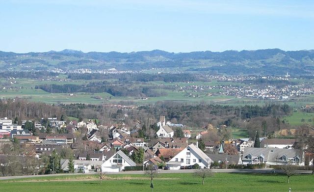
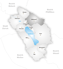
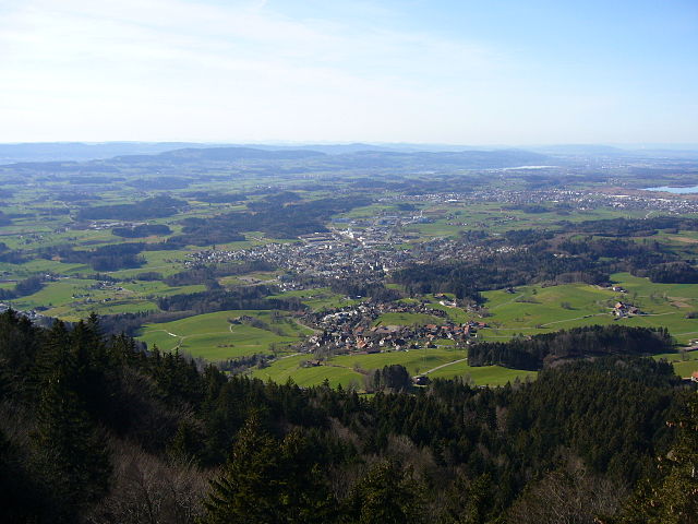
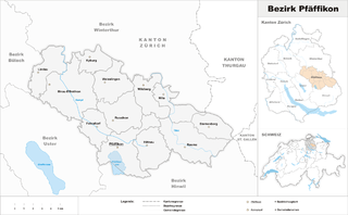
Устер (Uster District, Bezirk Uster)

 Hiking in Устер
Uster District, located in the canton of Zurich in Switzerland, offers a variety of hiking opportunities that cater to different skill levels and preferences. The lush landscapes, scenic lakes, and picturesque hills make it an appealing destination for nature lovers and outdoor enthusiasts. Here are some highlights and suggestions for hiking in Uster District:
1.
- Hiking Trails: Along the shores of Lake Zurich, there are several trails where you can enjoy beautiful views of the lake and surrounding mountains. These trails are generally flat and suitable for all skill levels.
- Water Activities: The lake area not only offers hiking but also opportunities for swimming, picnicking, and enjoying water sports.
2.
- Trail Around the Lake: The trail that circles Lake Greifensee is a popular option for hikers. The path is approximately 16 kilometers and features diverse landscapes, including wetlands and forests.
- Wildlife: This area is a haven for birdwatching, so keep an eye out for various bird species along the way.
3.
- Uster Nature Reserve: This protected area offers several shorter hiking routes with well-marked paths, where you can immerse yourself in the local flora and fauna.
- Landschaftspark Uster: This park provides various walking paths that are perfect for a leisurely hike or a quick nature stroll.
4.
- Although Uetliberg is located a bit farther out, it's a popular hiking destination that offers panoramic views of the Zurich region. You can reach it from Uster by connecting through other trails or public transport.
5.
- Local Maps: Be sure to pick up local hiking maps or use reliable online resources to plan your routes, as trails can vary in difficulty.
- Weather Considerations: Swiss weather can change quickly, so check conditions before heading out and dress in layers.
- Safety: Always carry enough water and snacks, and let someone know your planned route and estimated return time.
- Public Transport: Uster is well-connected by train and bus, making it easy to access various hiking trails.
6.
- Spring and summer months are ideal for hiking due to the mild weather and blooming landscapes.
- Autumn offers stunning foliage, while winter hikes can be enjoyed in the lower areas; however, some trails may be snow-covered and require appropriate gear.
Whether you're looking for a peaceful lakeside stroll or a more challenging hike through the hills, Uster District has something to offer for every hiking enthusiast. Enjoy your time in this beautiful region!
- Страна:

- Столица: Устер
- Код автомобильного номера: ZH
- Координаты: 47° 21' 0" N, 8° 41' 0" E


- GPS треки (wikiloc): [Ссылка]
- Высота над уровнем моря: 433 м m
- Площадь: 112.35 кв.км
- Википедия русская: wiki(ru)
- Википедия английская: wiki(en)
- Википедия национальная: wiki(de)
- Хранилище Wikidata: Wikidata: Q262156
- Катеория в википедии: [Ссылка]
- код Freebase: [/m/0flzz6]
- код GeoNames: Альт: [6458751]
- идентификатор местоположения ArchINFORM: [5892]
Включает регионы:


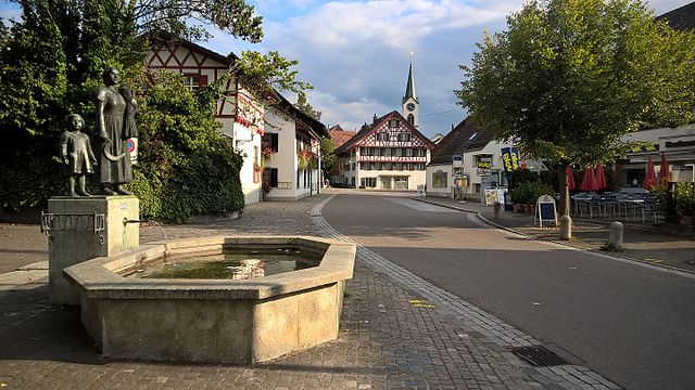
Устер
Hiking in Устер
Uster, located in the Zurich canton of Switzerland, is surrounded by beautiful landscapes and offers a variety of hiking opportunities. The region is known for its stunning views, well-marked trails, and a mix of nature and charming Swiss villages. Here are some highlights and important tips for hiking in Uster:...
- Страна:
- Почтовый код: 8613; 8612; 8610
- Телефонный код: 044
- Код автомобильного номера: ZH
- Координаты: 47° 20' 57" N, 8° 43' 9" E
- GPS треки (wikiloc): [Ссылка]
- Высота над уровнем моря: 464 м m
- Площадь: 28.56 кв.км
- Население: 34442
- Веб сайт: [Ссылка]


Дюбендорф
Hiking in Дюбендорф
Dübendorf, located in the canton of Zurich, Switzerland, offers a fantastic environment for hiking enthusiasts. Nestled close to the urban area of Zurich, it provides a wonderful balance of nature and accessibility....
- Страна:
- Почтовый код: 8600
- Телефонный код: 044
- Код автомобильного номера: ZH
- Координаты: 47° 23' 26" N, 8° 37' 2" E
- GPS треки (wikiloc): [Ссылка]
- Высота над уровнем моря: 439 м m
- Площадь: 13.61 кв.км
- Население: 28002
- Веб сайт: [Ссылка]


Маур
Hiking in Маур
Hiking in Maur, Switzerland, offers a picturesque escape into the Swiss countryside, characterized by lush landscapes, quaint villages, and stunning views of the surrounding Alps....
- Страна:
- Почтовый код: 8124
- Телефонный код: 044
- Код автомобильного номера: ZH
- Координаты: 47° 20' 30" N, 8° 40' 13" E
- GPS треки (wikiloc): [Ссылка]
- Высота над уровнем моря: 478 м m
- Площадь: 18.40 кв.км
- Население: 10148
- Веб сайт: [Ссылка]


Фелланден
Hiking in Фелланден
Fällanden, located in the Canton of Zurich in Switzerland, offers some lovely hiking opportunities, particularly for those looking to enjoy a combination of nature and picturesque views. Here are some key points about hiking in Fällanden:...
- Страна:
- Почтовый код: 8117
- Код автомобильного номера: ZH
- Координаты: 47° 22' 18" N, 8° 38' 24" E
- GPS треки (wikiloc): [Ссылка]
- Высота над уровнем моря: 491 м m
- Площадь: 6.41 кв.км
- Население: 8575
- Веб сайт: [Ссылка]

Эгг (Цюрих)
Hiking in Эгг (Цюрих)
Egg, located in the Canton of Zurich in Switzerland, is a charming village nestled in the lush landscapes of the Zürcher Oberland. It offers a variety of hiking options suitable for all skill levels. Here are some highlights of hiking in and around Egg:...
- Страна:
- Почтовый код: 8132
- Телефонный код: 01; 043; 044
- Код автомобильного номера: ZH
- Координаты: 47° 18' 7" N, 8° 41' 26" E
- GPS треки (wikiloc): [Ссылка]
- Высота над уровнем моря: 545 м m
- Площадь: 14.48 кв.км
- Население: 8452
- Веб сайт: [Ссылка]


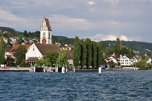
Грайфензее
Hiking in Грайфензее
Hiking around Greifensee, located just outside Zürich, offers a wonderful mix of scenic views, nature, and cultural experiences. The lake itself is a popular destination for outdoor enthusiasts, and the surrounding trails provide a variety of options suitable for different skill levels. Here are some highlights about hiking in this beautiful area:...
- Страна:
- Почтовый код: 8606
- Телефонный код: 044
- Код автомобильного номера: ZH
- Координаты: 47° 21' 58" N, 8° 40' 43" E
- GPS треки (wikiloc): [Ссылка]
- Высота над уровнем моря: 439 м m
- Площадь: 2.30 кв.км
- Население: 5345
- Веб сайт: [Ссылка]


Мёнхальторф
Hiking in Мёнхальторф
Mönchaltorf is a charming village located in the Zurich region of Switzerland, surrounded by beautiful landscapes and offering several hiking opportunities. The area is characterized by its scenic hills, forests, and agricultural landscapes, making it a perfect destination for outdoor enthusiasts....
- Страна:
- Почтовый код: 8617
- Телефонный код: 044
- Код автомобильного номера: ZH
- Координаты: 47° 18' 41" N, 8° 43' 20" E
- GPS треки (wikiloc): [Ссылка]
- Высота над уровнем моря: 442 м m
- Площадь: 7.62 кв.км
- Население: 3715
- Веб сайт: [Ссылка]


Шверценбах
Hiking in Шверценбах
Schwerzenbach is located in Switzerland, in the canton of Zurich. This area offers various outdoor activities, including hiking. Here are some points of interest regarding hiking in and around Schwerzenbach:...
- Страна:
- Почтовый код: 8603
- Телефонный код: 044
- Код автомобильного номера: ZH
- Координаты: 47° 22' 55" N, 8° 39' 21" E
- GPS треки (wikiloc): [Ссылка]
- Высота над уровнем моря: 441 м m
- Площадь: 2.64 кв.км
- Население: 5088
- Веб сайт: [Ссылка]

Ванген-Брюттизеллен
Hiking in Ванген-Брюттизеллен
Wangen-Brüttisellen, located in the Zurich area of Switzerland, offers some lovely hiking opportunities, particularly for those who enjoy exploring green landscapes, hills, and nearby natural reserves. While the region might not be the most famous hiking destination, it presents excellent options for both casual walkers and more experienced hikers....
- Страна:
- Почтовый код: 8602
- Телефонный код: 044
- Код автомобильного номера: ZH
- Координаты: 47° 24' 43" N, 8° 38' 47" E
- GPS треки (wikiloc): [Ссылка]
- Высота над уровнем моря: 465 м m
- Площадь: 7.90 кв.км
- Население: 7892
- Веб сайт: [Ссылка]
Фолькетсвиль
Hiking in Фолькетсвиль
Volketswil is a charming municipality in the Zurich metropolitan area of Switzerland, offering a blend of urban amenities and access to nature. While Volketswil itself may not be a major hiking destination, it provides various opportunities for outdoor activities, including hiking....
- Страна:
- Почтовый код: 8604
- Телефонный код: 044
- Код автомобильного номера: ZH
- Координаты: 47° 23' 33" N, 8° 41' 22" E
- GPS треки (wikiloc): [Ссылка]
- Высота над уровнем моря: 487 м m
- Площадь: 14.0 кв.км
- Население: 18615
- Веб сайт: [Ссылка]
Граничит с регионами:

Майлен
Hiking in Майлен
Meilen District, located in the Canton of Zurich in Switzerland, offers several beautiful hiking opportunities with stunning views of Lake Zurich and the surrounding landscapes. Here are some highlights and recommended trails for hiking in the area:...
- Страна:
- Столица: Майлен
- Код автомобильного номера: ZH
- Координаты: 47° 16' 0" N, 8° 40' 0" E
- GPS треки (wikiloc): [Ссылка]
- Высота над уровнем моря: 568 м m
- Площадь: 84.64 кв.км

Хинвиль
- округ в кантоне Цюрих (Швейцария)
Hiking in Хинвиль
Hinwil District, located in the canton of Zurich in Switzerland, offers a variety of hiking opportunities that cater to all levels of experience. The beautiful landscapes, lush forests, and scenic views make it an attractive destination for outdoor enthusiasts....
- Страна:
- Столица: Хинвиль
- Код автомобильного номера: ZH
- Координаты: 47° 18' 0" N, 8° 51' 0" E
- GPS треки (wikiloc): [Ссылка]
- Высота над уровнем моря: 558 м m

Пфеффикон
Hiking in Пфеффикон
Pfäffikon District, located in the canton of Zurich, Switzerland, offers a picturesque landscape that's ideal for hiking enthusiasts. It's characterized by rolling hills, lush forests, and scenic lakes, making it a beautiful destination for outdoor activities....
- Страна:
- Столица: Пфеффикон
- Код автомобильного номера: ZH
- Координаты: 47° 24' 0" N, 8° 47' 0" E
- GPS треки (wikiloc): [Ссылка]
- Высота над уровнем моря: 715 м m
- Площадь: 163.55 кв.км


Цюрих
- округ в Швейцарии
Hiking in Цюрих
Hiking in the Zürich District offers a wonderful blend of urban and natural experiences. The area provides a variety of trails that cater to different skill levels, from easy walks suitable for families to more challenging hikes for seasoned adventurers. Here are some popular hiking spots and trails you might consider:...
- Страна:
- Столица: Цюрих
- Код автомобильного номера: ZH
- Координаты: 47° 23' 0" N, 8° 32' 0" E
- GPS треки (wikiloc): [Ссылка]
- Высота над уровнем моря: 412 м m
- Площадь: 87.78 кв.км
- Веб сайт: [Ссылка]


Бюлах
Hiking in Бюлах
Bülach District, located in the Canton of Zurich in Switzerland, offers a variety of hiking opportunities that cater to different skill levels and preferences. The region is characterized by beautiful landscapes, cultivated fields, lush forests, and historic towns....
- Страна:
- Столица: Бюлах
- Код автомобильного номера: ZH
- Координаты: 47° 40' 0" N, 8° 34' 0" E
- GPS треки (wikiloc): [Ссылка]
- Высота над уровнем моря: 564 м m
- Площадь: 185.19 кв.км
- Население: 117000