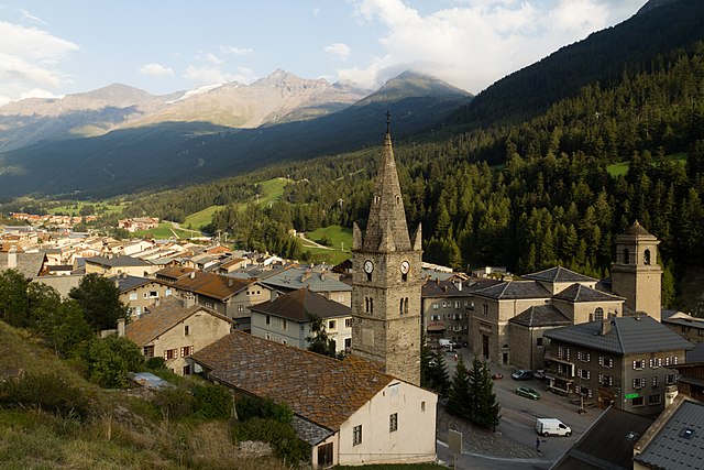
Венаус (Venaus, Venaus)

- коммуна в Италии
 Hiking in Венаус
Venaus is a small village located in the Susa Valley of the Piedmont region in Italy. It is surrounded by the beautiful Alps, making it an excellent destination for hiking enthusiasts. Here are some highlights about hiking in and around Venaus:
Scenic Trails
-
Mountain Trails: Venaus offers a variety of trails that vary in difficulty, accommodating both beginners and experienced hikers. Many trails provide stunning views of the surrounding mountains and valleys.
-
Via Alpina: Part of the Via Alpina, a long-distance hiking trail that traverses the entire Alpine region, passes near Venaus. This trail can lead you to some breathtaking panoramas and quaint mountain villages.
-
Valle di Susa: The valley itself is dotted with numerous hiking routes, ranging from gentle walks along rivers to challenging ascents to mountain peaks. Explore different trails that lead to picturesque lakes and historical forts.
Tips for Hiking in Venaus
- Preparation: Always check weather conditions and be prepared for changing weather typical in mountainous regions. Bring appropriate clothing, plenty of water, and snacks.
- Maps and Markers: Use local maps or GPS apps to navigate your route. Trails are usually well-marked, but it’s good to have a plan.
- Wildlife Spotting: Keep an eye out for local wildlife, including deer, marmots, and a variety of bird species.
Best Times to Hike
- Spring & Fall: These seasons typically offer mild weather and beautiful scenery, with wildflowers in the spring and vibrant foliage in the fall.
- Summer: Ideal for hiking, especially at higher altitudes where temperatures are cooler. However, be cautious of potential thunderstorms.
Local Culture and Attractions
- Historical Sites: Venaus has historical sites worth exploring, like ancient churches and fortified structures, which can add to your hiking experience.
- Cuisine: After a day of hiking, enjoy the local cuisine in traditional restaurants or tavernas. Try local specialties like polenta, bagna càuda, and various alpine cheeses.
Whether you are looking for a peaceful hike or a challenging trek, Venaus and its surroundings provide diverse options to explore the natural beauty and culture of the region. Always remember to leave no trace and respect the environment during your hikes!
- Страна:

- Почтовый код: 10050
- Телефонный код: 0122
- Код автомобильного номера: TO
- Координаты: 45° 9' 0" N, 7° 1' 0" E


- GPS треки (wikiloc): [Ссылка]
- Высота над уровнем моря: 604 м m
- Площадь: 19.14 кв.км
- Население: 879
- Веб сайт: http://www.comune.venaus.to.it/
- Википедия русская: wiki(ru)
- Википедия английская: wiki(en)
- Википедия национальная: wiki(it)
- Хранилище Wikidata: Wikidata: Q10342
- Катеория в википедии: [Ссылка]
- код Freebase: [/m/0g8mvv]
- код GeoNames: Альт: [6540925]
- код VIAF: Альт: [259767756]
- ID отношения в OpenStreetMap: [44372]
- код TGN: [1045421]
- UN/LOCODE: [ITVUS]
- код ISTAT: 001291
- кадастровый код Италии: L726
Граничит с регионами:


Bramans
- коммуна во Франции
Hiking in Bramans
Bramans is a charming village located in the Savoie region of the French Alps, known for its stunning natural landscapes and outdoor activities, including hiking. The area offers a variety of hiking trails that cater to different skill levels, making it a great destination for both beginner and experienced hikers....
- Страна:

- Почтовый код: 73500
- Координаты: 45° 13' 25" N, 6° 46' 34" E
- GPS треки (wikiloc): [Ссылка]
- Площадь: 92.26 кв.км
- Население: 435
- Веб сайт: [Ссылка]

Ланлебур-Мон-Сени
- коммуна во Франции
Hiking in Ланлебур-Мон-Сени
Lanslebourg-Mont-Cenis, located in the Savoie region of France, is a stunning destination for hiking enthusiasts. Nestled in the French Alps, this area offers a variety of trails that cater to different levels of hiking experience, from gentle walks to more challenging climbs....
- Страна:
- Почтовый код: 73480
- Координаты: 45° 17' 9" N, 6° 52' 45" E
- GPS треки (wikiloc): [Ссылка]
- Площадь: 93.61 кв.км
- Население: 649
- Веб сайт: [Ссылка]


Джальоне
- коммуна Италии
Hiking in Джальоне
Giaglione is a picturesque village located in the Susa Valley of the Piedmont region in northwest Italy. It’s an ideal location for hiking enthusiasts, offering stunning views of the surrounding alpine landscape and numerous trails suitable for various skill levels....
- Страна:
- Почтовый код: 10050
- Телефонный код: 0122
- Код автомобильного номера: TO
- Координаты: 45° 8' 23" N, 7° 0' 51" E
- GPS треки (wikiloc): [Ссылка]
- Высота над уровнем моря: 774 м m
- Площадь: 33.38 кв.км
- Население: 619
- Веб сайт: [Ссылка]
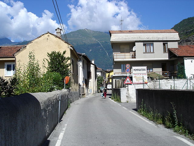
Момпантеро
- коммуна Италии
Hiking in Момпантеро
Mompantero, located in the province of Turin in the Piedmont region of Italy, is a charming destination for hikers looking to explore beautiful landscapes and enjoy outdoor activities. Nestled in the Susa Valley, this area is characterized by its stunning mountainous terrain, rich biodiversity, and picturesque views of the surrounding Alps....
- Страна:
- Почтовый код: 10059
- Телефонный код: 0122
- Код автомобильного номера: TO
- Координаты: 45° 9' 0" N, 7° 4' 0" E
- GPS треки (wikiloc): [Ссылка]
- Высота над уровнем моря: 531 м m
- Площадь: 30.33 кв.км
- Население: 646
- Веб сайт: [Ссылка]

Монченизио
- коммуна Италии
Hiking in Монченизио
Moncenisio, located in the Piedmont region of Italy, is a stunning destination for hiking enthusiasts. Situated near the French border and the impressive backdrop of the Alps, this area offers a mix of scenic trails, diverse landscapes, and rich history....
- Страна:
- Почтовый код: 10050
- Телефонный код: 0122
- Код автомобильного номера: TO
- Координаты: 45° 12' 0" N, 6° 59' 0" E
- GPS треки (wikiloc): [Ссылка]
- Высота над уровнем моря: 1460 м m
- Площадь: 4.5 кв.км
- Население: 29
- Веб сайт: [Ссылка]


Новалеза
- коммуна Италии
Hiking in Новалеза
Novalesa is a picturesque village located in the Susa Valley of the Piedmont region in northern Italy. It is surrounded by the stunning natural beauty of the Alps, making it an excellent spot for hiking enthusiasts. Here’s what you can expect when hiking in and around Novalesa:...
- Страна:
- Почтовый код: 10050
- Телефонный код: 0122
- Код автомобильного номера: TO
- Координаты: 45° 11' 0" N, 7° 1' 0" E
- GPS треки (wikiloc): [Ссылка]
- Высота над уровнем моря: 828 м m
- Площадь: 28.55 кв.км
- Население: 542
- Веб сайт: [Ссылка]