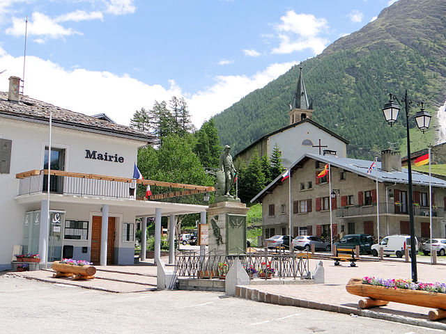
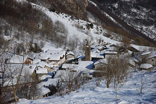
Ланлебур-Мон-Сени (Lanslebourg-Mont-Cenis, Lanslebourg-Mont-Cenis)

- коммуна во Франции
 Hiking in Ланлебур-Мон-Сени
Lanslebourg-Mont-Cenis, located in the Savoie region of France, is a stunning destination for hiking enthusiasts. Nestled in the French Alps, this area offers a variety of trails that cater to different levels of hiking experience, from gentle walks to more challenging climbs.
Popular Hiking Trails
-
Val Cenis Trail: This trail takes you through the beautiful Val Cenis valley, showcasing lush pastures, alpine flowers, and stunning mountain views. It's suitable for families and moderate hikers.
-
Col du Mont-Cenis: A more challenging hike, this route offers scenic views of the surrounding peaks and the chance to explore the historic sites nearby, including the ancient Roman road.
-
Lac de la Partie: A picturesque hike that leads to a beautiful mountain lake. It's a great spot for a picnic and offers a perfect place for photography.
-
Les Aiguilles d’Arves: For experienced hikers, this trek provides incredible panoramic views and takes you up to some of the most breathtaking peaks in the region.
Hiking Tips
-
Season: The best time to hike in Lanslebourg-Mont-Cenis is late spring through early autumn (June to September). Be sure to check trail conditions, as snow can linger on higher trails into late June.
-
Gear: Wear proper hiking boots and pack weather-appropriate clothing. It's also wise to carry plenty of water, snacks, and a first-aid kit.
-
Local Map: Grab a local hiking map or guidebook to help navigate the trails. The tourism office can provide valuable information on trail conditions and recommendations.
Safety Considerations
- Always check the weather forecast before heading out, as conditions can change rapidly in the mountains.
- Inform someone about your hiking plans and estimated return time.
- Be aware of your physical capabilities and fitness level, and choose hikes that suit your skills.
Additional Activities
Beyond hiking, Lanslebourg-Mont-Cenis offers opportunities for cycling, skiing in winter, and enjoying local cuisine in the picturesque villages. Overall, it’s a wonderful destination for those who appreciate natural beauty and outdoor adventures.
- Страна:

- Почтовый код: 73480
- Координаты: 45° 17' 9" N, 6° 52' 45" E


- GPS треки (wikiloc): [Ссылка]
- Площадь: 93.61 кв.км
- Население: 649
- Веб сайт: http://www.lanslebourg-montcenis.fr/
- Википедия русская: wiki(ru)
- Википедия английская: wiki(en)
- Википедия национальная: wiki(fr)
- Хранилище Wikidata: Wikidata: Q752477
- Катеория в википедии: [Ссылка]
- код Freebase: [/m/03npgw4]
- код GeoNames: Альт: [6442814]
- код BNF: [15274076v]
- код муниципалитета INSEE: 73143
Граничит с регионами:


Венаус
- коммуна в Италии
Hiking in Венаус
Venaus is a small village located in the Susa Valley of the Piedmont region in Italy. It is surrounded by the beautiful Alps, making it an excellent destination for hiking enthusiasts. Here are some highlights about hiking in and around Venaus:...
- Страна:

- Почтовый код: 10050
- Телефонный код: 0122
- Код автомобильного номера: TO
- Координаты: 45° 9' 0" N, 7° 1' 0" E
- GPS треки (wikiloc): [Ссылка]
- Высота над уровнем моря: 604 м m
- Площадь: 19.14 кв.км
- Население: 879
- Веб сайт: [Ссылка]


Lanslevillard
- коммуна во Франции
Hiking in Lanslevillard
Lanslevillard, located in the Savoie region of France, is a beautiful destination for hiking enthusiasts. Nestled in the heart of the French Alps, this charming alpine village offers a range of hiking trails that cater to all experience levels, from beginners to seasoned hikers. Here are some key highlights about hiking in Lanslevillard:...
- Страна:
- Почтовый код: 73480
- Координаты: 45° 17' 22" N, 6° 54' 42" E
- GPS треки (wikiloc): [Ссылка]
- Площадь: 39.84 кв.км
- Население: 468
- Веб сайт: [Ссылка]


Bramans
- коммуна во Франции
Hiking in Bramans
Bramans is a charming village located in the Savoie region of the French Alps, known for its stunning natural landscapes and outdoor activities, including hiking. The area offers a variety of hiking trails that cater to different skill levels, making it a great destination for both beginner and experienced hikers....
- Страна:
- Почтовый код: 73500
- Координаты: 45° 13' 25" N, 6° 46' 34" E
- GPS треки (wikiloc): [Ссылка]
- Площадь: 92.26 кв.км
- Население: 435
- Веб сайт: [Ссылка]


Termignon
- коммуна во Франции
Hiking in Termignon
Termignon is a charming village located in the Maurienne Valley in the French Alps, part of the Savoie region. It offers a variety of hiking opportunities for outdoor enthusiasts, ranging from leisurely walks to challenging treks with stunning views of the surrounding mountains and valleys. Here are some highlights of hiking in and around Termignon:...
- Страна:
- Почтовый код: 73500
- Координаты: 45° 16' 39" N, 6° 49' 1" E
- GPS треки (wikiloc): [Ссылка]
- Площадь: 149.03 кв.км
- Население: 400
- Веб сайт: [Ссылка]


Sollières-Sardières
- коммуна во Франции
Hiking in Sollières-Sardières
Sollières-Sardières is a charming village located in the French Alps, nestled between the Vanoise National Park and the Italian border. This region is known for its stunning mountain landscapes, rich biodiversity, and extensive hiking trails, making it an excellent destination for hikers of all levels....
- Страна:
- Почтовый код: 73500
- Координаты: 45° 15' 51" N, 6° 48' 30" E
- GPS треки (wikiloc): [Ссылка]
- Площадь: 33.31 кв.км
- Население: 189
- Веб сайт: [Ссылка]

Bessans
- коммуна во Франции
Hiking in Bessans
Bessans is a picturesque village located in the Savoie region of the French Alps, known for its stunning landscapes and outdoor activities, including hiking. Nestled at an altitude of about 1,740 meters, it offers a range of trails suitable for various skill levels, making it a great destination for both experienced hikers and families....
- Страна:
- Почтовый код: 73480
- Координаты: 45° 19' 12" N, 6° 59' 37" E
- GPS треки (wikiloc): [Ссылка]
- Высота над уровнем моря: 1750 м m
- Площадь: 128.08 кв.км
- Население: 338
- Веб сайт: [Ссылка]

Монченизио
- коммуна Италии
Hiking in Монченизио
Moncenisio, located in the Piedmont region of Italy, is a stunning destination for hiking enthusiasts. Situated near the French border and the impressive backdrop of the Alps, this area offers a mix of scenic trails, diverse landscapes, and rich history....
- Страна:
- Почтовый код: 10050
- Телефонный код: 0122
- Код автомобильного номера: TO
- Координаты: 45° 12' 0" N, 6° 59' 0" E
- GPS треки (wikiloc): [Ссылка]
- Высота над уровнем моря: 1460 м m
- Площадь: 4.5 кв.км
- Население: 29
- Веб сайт: [Ссылка]


Новалеза
- коммуна Италии
Hiking in Новалеза
Novalesa is a picturesque village located in the Susa Valley of the Piedmont region in northern Italy. It is surrounded by the stunning natural beauty of the Alps, making it an excellent spot for hiking enthusiasts. Here’s what you can expect when hiking in and around Novalesa:...
- Страна:
- Почтовый код: 10050
- Телефонный код: 0122
- Код автомобильного номера: TO
- Координаты: 45° 11' 0" N, 7° 1' 0" E
- GPS треки (wikiloc): [Ссылка]
- Высота над уровнем моря: 828 м m
- Площадь: 28.55 кв.км
- Население: 542
- Веб сайт: [Ссылка]