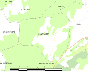
Verne (Verne)

- коммуна во Франции
 Hiking in Verne
Verne, located in the Doubs department of the Bourgogne-Franche-Comté region in eastern France, offers a variety of hiking opportunities for outdoor enthusiasts. The area is characterized by its beautiful natural landscapes, with rolling hills, lush forests, and picturesque valleys.
Hiking Opportunities
-
Trails: There are several hiking trails around Verne suitable for different skill levels. Many trails are well-marked and offer a chance to explore the local flora and fauna. Hiking maps are often available at local tourist offices.
-
Scenic Views: The hikes often lead to stunning panoramic viewpoints, where you can enjoy the beauty of the Doubs countryside. Expect to see features such as the Doubs River and rugged cliffs.
-
Nature Reserves: The nearby regions may include nature reserves and parks that provide a rich biodiversity. This is an excellent area for birdwatching and spotting other wildlife.
-
Historical Sites: While hiking, you may encounter local historical landmarks, like ancient churches or remnants of local culture, adding an educational aspect to your adventure.
-
Accessibility: Many trails are accessible for families and beginners, though more challenging routes are available for experienced hikers looking for a workout or a longer trek.
Tips for Hiking in Verne
- Weather: Check the weather before embarking on your hike, as conditions can change rapidly in mountainous areas.
- Footwear: Wear suitable hiking boots to navigate varied terrain comfortably.
- Hydration and Snacks: Bring enough water and some snacks to keep your energy levels up during your hike.
- Leave No Trace: Respect the environment by sticking to trails and taking all your trash with you.
Local Resources
- Tourist Information Centers: Visit the local tourist office for maps, trail information, and advice on current conditions.
- Guided Tours: Consider joining a local guided hike for an informative experience about the region's nature and history.
Exploring Verne and its surroundings can be a rewarding experience for hikers, combining physical activity with the beauty of the French landscape. Make sure to plan your hike according to your skill level and the time you have available.
- Страна:

- Почтовый код: 25110
- Координаты: 47° 23' 53" N, 6° 21' 14" E


- GPS треки (wikiloc): [Ссылка]
- Площадь: 7.82 кв.км
- Население: 130
- Веб сайт: http://www.village-de-verne.fr
- Википедия английская: wiki(en)
- Википедия национальная: wiki(fr)
- Хранилище Wikidata: Wikidata: Q905822
- Катеория в википедии: [Ссылка]
- код Freebase: [/m/03mhf2l]
- код GeoNames: Альт: [6430043]
- номер SIREN: [212506042]
- код BNF: [15252830v]
- код VIAF: Альт: [151626676]
- код LCNAF: Альт: [no2005041885]
- код ISNI: Альт: [0000 0001 2019 1834]
- код муниципалитета INSEE: 25604
Граничит с регионами:


Autechaux
- коммуна во Франции
Hiking in Autechaux
Autechaux, located in the Doubs department of France, offers a variety of scenic hiking opportunities. The region is characterized by its rolling hills, dense forests, and picturesque views, making it an excellent destination for nature enthusiasts....
- Страна:
- Почтовый код: 25110
- Координаты: 47° 22' 40" N, 6° 23' 7" E
- GPS треки (wikiloc): [Ссылка]
- Высота над уровнем моря: 437 м m
- Площадь: 6.59 кв.км
- Население: 418
- Веб сайт: [Ссылка]

Fontenotte
- коммуна во Франции
Hiking in Fontenotte
Hiking in Fontenotte, a picturesque area often associated with its natural beauty, can offer a delightful experience for outdoor enthusiasts. While specific trail details may vary, here are some general aspects you can expect:...
- Страна:
- Почтовый код: 25110
- Координаты: 47° 22' 35" N, 6° 19' 21" E
- GPS треки (wikiloc): [Ссылка]
- Площадь: 5.65 кв.км
- Население: 59

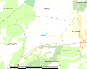
Luxiol
- коммуна во Франции
Hiking in Luxiol
It seems there might be some confusion with the name "Luxiol," as it doesn't correspond to a well-known hiking destination or national park. If you are referring to a specific location or have a typo, please provide more details so I can assist you accurately....
- Страна:
- Почтовый код: 25110
- Координаты: 47° 22' 52" N, 6° 20' 57" E
- GPS треки (wikiloc): [Ссылка]
- Площадь: 6.44 кв.км
- Население: 161


Vergranne
- коммуна во Франции
Hiking in Vergranne
Vergranne does not appear to be a well-known hiking destination, and it is possible that you may be referring to a specific location that is less widely recognized or that the name may be a misspelling. However, if you are interested in hiking in a particular region or natural area with a similar name or if you have a specific destination in mind, please provide more details....
- Страна:
- Почтовый код: 25110
- Координаты: 47° 24' 32" N, 6° 23' 27" E
- GPS треки (wikiloc): [Ссылка]
- Площадь: 5.18 кв.км
- Население: 107

Trouvans
- коммуна во Франции
Hiking in Trouvans
Trouvans, located in the beautiful French region of Bourgogne-Franche-Comté, offers a quaint and picturesque setting for hiking enthusiasts. While not as widely known as some other hiking destinations in France, it boasts scenic trails that are ideal for both beginners and more experienced hikers....
- Страна:
- Почтовый код: 25680
- Координаты: 47° 25' 24" N, 6° 20' 54" E
- GPS треки (wikiloc): [Ссылка]
- Площадь: 2.69 кв.км
- Население: 103


Tournans
- коммуна во Франции
Hiking in Tournans
Tournans is a beautiful area that offers a variety of hiking opportunities, showcasing its natural beauty and diverse landscapes. The region typically features scenic trails that can accommodate different skill levels, from beginner-friendly paths to more challenging routes for seasoned hikers....
- Страна:
- Почтовый код: 25680
- Координаты: 47° 24' 49" N, 6° 19' 39" E
- GPS треки (wikiloc): [Ссылка]
- Площадь: 9.14 кв.км
- Население: 132

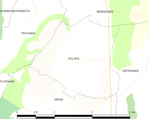
Rillans
- коммуна во Франции
Hiking in Rillans
Rillans is not a widely recognized hiking destination, but if you are referring to a specific area, such as a town or region with hiking trails, please clarify its location. If Rillans is a small locality or a lesser-known area, I'd recommend looking up local hiking maps or resources to get detailed trail information....
- Страна:
- Почтовый код: 25110
- Координаты: 47° 24' 47" N, 6° 21' 51" E
- GPS треки (wikiloc): [Ссылка]
- Площадь: 3.42 кв.км
- Население: 94