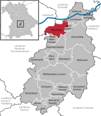
Фобург-на-Дунае (Vohburg an der Donau, Vohburg an der Donau)

 Hiking in Фобург-на-Дунае
Vohburg, located in Bavaria, Germany, offers a variety of hiking opportunities that can appeal to both casual walkers and more serious hikers. Here are some highlights and tips for hiking in and around Vohburg:
Trail Options
-
Local Trails: Vohburg has access to numerous smaller trails that weave through the countryside. These trails are often well-marked, making them easy to navigate. Look for routes that take you through local forests, meadows, and along rivers.
-
Danube River Trails: Since Vohburg is situated near the Danube River, hikes along the riverbanks can be stunning. The trails here usually offer picturesque views and can be paired with areas to rest or picnic.
-
Nearby Nature Reserves: Explore nearby natural reserves and protected areas. They often have designated hiking paths that allow you to enjoy diverse flora and fauna.
Hiking Tips
- Weather Preparation: Bavaria can have variable weather, so check the forecast and dress in layers. Bring rain gear just in case.
- Footwear: Ensure you wear comfortable and appropriate footwear, especially if you’re tackling uneven terrain.
- Map and Navigation: While many trails are well-marked, carrying a map or using a hiking app can be helpful.
- Stay Hydrated: Bring enough water, especially if you plan on doing longer hikes. Some trails may not have easy access to water sources.
- Timing: Plan your hikes during daylight hours. Depending on the season, this can mean starting early or checking the sunset time.
Points of Interest
- Historical Sites: Along your hiking route, you may encounter historical landmarks or small villages that are worth a visit.
- Cultural Experiences: Check local events or festivals that may be happening during your hike. Engaging with local culture can enhance your experience.
Local Hiking Groups
Consider joining local hiking clubs or groups if you’re looking to meet people or explore the trails with more experienced hikers. They often have scheduled hikes and outings, which can be a great way to discover hidden gems.
In summary, Vohburg and its surrounding areas offer charming hiking opportunities with beautiful landscapes, cultural landmarks, and a variety of trail options suitable for all skill levels. Enjoy your hike!
- Страна:

- Почтовый код: 85088
- Телефонный код: 08457
- Код автомобильного номера: PAF
- Координаты: 48° 46' 11" N, 11° 37' 6" E


- GPS треки (wikiloc): [Ссылка]
- Высота над уровнем моря: 371 м m
- Площадь: 45.19 кв.км
- Население: 5863
- Веб сайт: http://www.vohburg.de
- Википедия русская: wiki(ru)
- Википедия английская: wiki(en)
- Википедия национальная: wiki(de)
- Хранилище Wikidata: Wikidata: Q251778
- Катеория в википедии: [Ссылка]
- код Freebase: [/m/0fksvw]
- код GeoNames: Альт: [6559197]
- код VIAF: Альт: [246266956]
- ID отношения в OpenStreetMap: [380987]
- код GND: Альт: [4409512-0]
- идентификатор местоположения ArchINFORM: [13406]
- место в MusicBrainz: [da1ebf73-70f4-42bf-b852-cde4963f37a5]
- код Historical Gazetteer: [VOHNAUJN58TS]
- Bavarikon ID: [ODB_A00001289]
- идентификатор муниципалитетов в Германии: 09186158
Граничит с регионами:

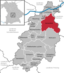
Манхинг
Hiking in Манхинг
Hiking in and around Manching, a town located in Bavaria, Germany, offers a delightful experience for outdoor enthusiasts. While Manching itself is not a major hiking destination, its proximity to the Danube River and various scenic landscapes provides opportunities for leisurely walks and more adventurous treks. Here are some highlights to consider when hiking in and around the area:...
- Страна:
- Почтовый код: 85077; W-8071; W-8072; 8071; 8072
- Телефонный код: 08459
- Код автомобильного номера: PAF
- Координаты: 48° 43' 7" N, 11° 29' 50" E
- GPS треки (wikiloc): [Ссылка]
- Высота над уровнем моря: 366 м m
- Площадь: 35.45 кв.км
- Население: 9235
- Веб сайт: [Ссылка]


Эрнсгаден
Hiking in Эрнсгаден
Ernsgaden is a small district located near the town of Pfaffenhofen an der Ilm in Bavaria, Germany. While it may not be widely known as a hiking destination, the surrounding area offers some beautiful landscapes and trails suitable for hiking enthusiasts....
- Страна:
- Почтовый код: 85119
- Телефонный код: 08452
- Код автомобильного номера: PAF
- Координаты: 48° 44' 0" N, 11° 35' 0" E
- GPS треки (wikiloc): [Ссылка]
- Высота над уровнем моря: 316 м m
- Площадь: 7.41 кв.км
- Население: 1138
- Веб сайт: [Ссылка]


Айгльсбах
Hiking in Айгльсбах
Aiglsbach, located in Bavaria, Germany, offers a peaceful and beautiful setting for hiking enthusiasts. The area is characterized by gentle hills, lush forests, and picturesque lakes, making it an excellent destination for both casual walkers and more experienced hikers....
- Страна:
- Почтовый код: 84089
- Телефонный код: 08753
- Код автомобильного номера: KEH
- Координаты: 48° 42' 0" N, 11° 43' 0" E
- GPS треки (wikiloc): [Ссылка]
- Высота над уровнем моря: 415 м m
- Площадь: 39.85 кв.км
- Население: 1331
- Веб сайт: [Ссылка]

Гайзенфельд
Hiking in Гайзенфельд
Geisenfeld, located in Bavaria, Germany, offers a charming environment for hiking enthusiasts. The region is characterized by picturesque landscapes, tranquil countryside, and well-marked trails that cater to various skill levels. Here are some key points to consider for hiking in Geisenfeld:...
- Страна:
- Почтовый код: 85290
- Телефонный код: 08452
- Код автомобильного номера: PAF
- Координаты: 48° 40' 0" N, 11° 36' 0" E
- GPS треки (wikiloc): [Ссылка]
- Высота над уровнем моря: 385 м m
- Площадь: 88.33 кв.км
- Население: 7689
- Веб сайт: [Ссылка]


Обердоллинг
Hiking in Обердоллинг
Oberdolling is a picturesque village in Bavaria, Germany, surrounded by lush landscapes, making it an excellent location for hiking enthusiasts. While it may not be as widely known as some other hiking destinations in the region, there are still several trails and opportunities to explore the natural beauty of the area....
- Страна:
- Почтовый код: 85129; W-8071; 8071
- Телефонный код: 08404
- Код автомобильного номера: EI
- Координаты: 48° 50' 0" N, 11° 35' 0" E
- GPS треки (wikiloc): [Ссылка]
- Высота над уровнем моря: 382 м m
- Площадь: 19.36 кв.км
- Население: 826
- Веб сайт: [Ссылка]


Мюнксмюнстер
Hiking in Мюнксмюнстер
Münchsmünster, located in Bavaria, Germany, offers a peaceful escape for hiking enthusiasts looking for serene landscapes and a touch of nature. The area is characterized by its picturesque countryside, rolling hills, and lush forests, making it an excellent destination for both novice and experienced hikers....
- Страна:
- Почтовый код: 85126
- Телефонный код: 08402
- Код автомобильного номера: PAF
- Координаты: 48° 45' 51" N, 11° 41' 28" E
- GPS треки (wikiloc): [Ссылка]
- Высота над уровнем моря: 357 м m
- Площадь: 16.21 кв.км
- Население: 2922
- Веб сайт: [Ссылка]


Гросмеринг
Hiking in Гросмеринг
Großmehring, located in Bavaria, Germany, is a charming area perfect for hiking enthusiasts. Nestled near the Danube River, it boasts scenic landscapes, lush greenery, and several trails that cater to all levels of hikers....
- Страна:
- Почтовый код: 85098; W-8071; 8071
- Телефонный код: 08407
- Код автомобильного номера: EI
- Координаты: 48° 46' 0" N, 11° 31' 59" E
- GPS треки (wikiloc): [Ссылка]
- Высота над уровнем моря: 375 м m
- Площадь: 47.38 кв.км
- Население: 4053
- Веб сайт: [Ссылка]


Пфёрринг
Hiking in Пфёрринг
Pförring, located in Bavaria, Germany, is a quaint town surrounded by scenic landscapes that can be appealing for hikers. While there may not be extensive hiking trails specifically in Pförring itself, the surrounding areas offer beautiful countryside and potential routes for outdoor enthusiasts....
- Страна:
- Почтовый код: 85104; W-8071; 8071
- Телефонный код: 08403
- Код автомобильного номера: EI
- Координаты: 48° 48' 30" N, 11° 41' 24" E
- GPS треки (wikiloc): [Ссылка]
- Высота над уровнем моря: 356 м m
- Площадь: 43.54 кв.км
- Население: 2881
- Веб сайт: [Ссылка]


Dürnbucher Forst
Hiking in Dürnbucher Forst
Dürnbucher Forst, located near the urban area of Regensburg in Bavaria, Germany, is a beautiful destination for hiking enthusiasts. The forest is characterized by its lush greenery, diverse plant life, and serene atmosphere, making it ideal for nature walks and outdoor activities. Here are some key points to consider if you’re planning a hike in Dürnbucher Forst:...
- Страна:
- Координаты: 48° 44' 0" N, 11° 44' 0" E
- GPS треки (wikiloc): [Ссылка]