Éton (Éton)

- commune in Meuse, France
- Country:

- Postal Code: 55240
- Coordinates: 49° 16' 30" N, 5° 40' 44" E


- GPS tracks (wikiloc): [Link]
- Area: 11.11 sq km
- Population: 208
- Wikipedia en: wiki(en)
- Wikipedia: wiki(fr)
- Wikidata storage: Wikidata: Q1453322
- Wikipedia Commons Category: [Link]
- Freebase ID: [/m/03qdqv4]
- GeoNames ID: Alt: [6437002]
- SIREN number: [215501826]
- BnF ID: [15264849z]
- INSEE municipality code: 55182
Shares border with regions:

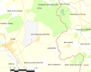
Rouvres-en-Woëvre
- commune in Meuse, France
- Country:
- Postal Code: 55400
- Coordinates: 49° 13' 8" N, 5° 41' 22" E
- GPS tracks (wikiloc): [Link]
- Area: 16.74 sq km
- Population: 615


Dommary-Baroncourt
- commune in Meuse, France
- Country:
- Postal Code: 55240
- Coordinates: 49° 17' 9" N, 5° 42' 12" E
- GPS tracks (wikiloc): [Link]
- Area: 12.49 sq km
- Population: 764

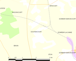
Gouraincourt
- commune in Meuse, France
- Country:
- Postal Code: 55230
- Coordinates: 49° 17' 38" N, 5° 39' 47" E
- GPS tracks (wikiloc): [Link]
- Area: 5.45 sq km
- Population: 53


Senon
- commune in Meuse, France
- Country:
- Postal Code: 55230
- Coordinates: 49° 16' 43" N, 5° 38' 29" E
- GPS tracks (wikiloc): [Link]
- Area: 19.89 sq km
- Population: 329

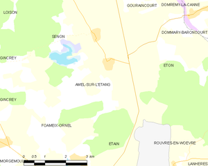
Amel-sur-l'Étang
- commune in Meuse, France
- Country:
- Postal Code: 55230
- Coordinates: 49° 15' 59" N, 5° 38' 54" E
- GPS tracks (wikiloc): [Link]
- Area: 14.74 sq km
- Population: 167


Domremy-la-Canne
- commune in Meuse, France
- Country:
- Postal Code: 55240
- Coordinates: 49° 17' 50" N, 5° 41' 36" E
- GPS tracks (wikiloc): [Link]
- Area: 3.09 sq km
- Population: 35