
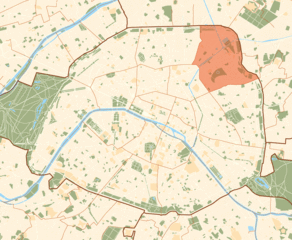
18th arrondissement of Paris (18e arrondissement de Paris)

- one of the arrondissements of Paris, France
- Country:

- Postal Code: 75018
- Coordinates: 48° 53' 32" N, 2° 20' 40" E


- GPS tracks (wikiloc): [Link]
- Area: 6.01 sq km
- Population: 201975
- Web site: http://www.mairie18.paris.fr/
- Wikipedia en: wiki(en)
- Wikipedia: wiki(fr)
- Wikidata storage: Wikidata: Q200126
- Wikipedia Commons Category: [Link]
- Wikipedia Commons Maps Category: [Link]
- Freebase ID: [/m/01r5st]
- GeoNames ID: Alt: [6618624]
- BnF ID: [11975583d]
- VIAF ID: Alt: [159132799]
- OSM relation ID: [9531]
- GND ID: Alt: [4638546-0]
- archINFORM location ID: [3740]
- Twitter username: Alt: [mairie18paris]
- ISNI: Alt: [0000 0001 0610 4060]
- BabelNet ID: [02318774n]
- INSEE municipality code: 75118
Shares border with regions:

10th arrondissement of Paris
- one of the 20 administrative districts of Paris, France
- Country:
- Postal Code: 75010
- Coordinates: 48° 52' 32" N, 2° 21' 28" E
- GPS tracks (wikiloc): [Link]
- Area: 2.89 sq km
- Population: 96733
- Web site: [Link]

17th arrondissement of Paris
- one of the 20 administrative districts of Paris, France
- Country:
- Postal Code: 75017
- Coordinates: 48° 52' 56" N, 2° 18' 28" E
- GPS tracks (wikiloc): [Link]
- Area: 5.67 sq km
- Population: 170218
- Web site: [Link]

19th arrondissement of Paris
- one of the 20 administrative districts of Paris, France
- Country:
- Postal Code: 75019
- Coordinates: 48° 52' 56" N, 2° 22' 55" E
- GPS tracks (wikiloc): [Link]
- Area: 6.79 sq km
- Population: 185654
- Web site: [Link]


8th arrondissement of Paris
- administrative district of Paris
- Country:
- Postal Code: 75008
- Coordinates: 48° 52' 27" N, 2° 18' 40" E
- GPS tracks (wikiloc): [Link]
- Area: 3.88 sq km
- Population: 40849
- Web site: [Link]


9th arrondissement of Paris
- one of the 20 administrative districts of Paris, France
- Country:
- Postal Code: 75009
- Coordinates: 48° 52' 42" N, 2° 20' 13" E
- GPS tracks (wikiloc): [Link]
- Area: 2.18 sq km
- Population: 61046
- Web site: [Link]