
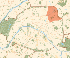
20th arrondissement of Paris (20e arrondissement de Paris)

- municipal district of Paris, France
- Country:

- Postal Code: 75020
- Coordinates: 48° 51' 54" N, 2° 23' 57" E


- GPS tracks (wikiloc): [Link]
- Area: 5.98 sq km
- Population: 198678
- Web site: http://www.mairie20.paris.fr/
- Wikipedia en: wiki(en)
- Wikipedia: wiki(fr)
- Wikidata storage: Wikidata: Q210720
- Wikipedia Commons Category: [Link]
- Wikipedia Commons Maps Category: [Link]
- Freebase ID: [/m/01r5tp]
- GeoNames ID: Alt: [6618626]
- BnF ID: [11955560b]
- VIAF ID: Alt: [139255365]
- OSM relation ID: [9529]
- GND ID: Alt: [4574625-4]
- archINFORM location ID: [3742]
- Twitter username: Alt: [Mairiedu20]
- ISNI: Alt: [0000 0000 9459 2588]
- INSEE municipality code: 75120
Shares border with regions:

10th arrondissement of Paris
- one of the 20 administrative districts of Paris, France
- Country:
- Postal Code: 75010
- Coordinates: 48° 52' 32" N, 2° 21' 28" E
- GPS tracks (wikiloc): [Link]
- Area: 2.89 sq km
- Population: 96733
- Web site: [Link]


11th arrondissement of Paris
- one of the 20 administrative districts of Paris, France
- Country:
- Postal Code: 75011
- Coordinates: 48° 51' 31" N, 2° 22' 46" E
- GPS tracks (wikiloc): [Link]
- Area: 3.67 sq km
- Population: 154411
- Web site: [Link]

12th arrondissement of Paris
- one of the 20 administrative districts of Paris, France
- Country:
- Postal Code: 75012
- Coordinates: 48° 50' 27" N, 2° 23' 17" E
- GPS tracks (wikiloc): [Link]
- Area: 6.38 sq km
- Population: 144595
- Web site: [Link]

19th arrondissement of Paris
- one of the 20 administrative districts of Paris, France
- Country:
- Postal Code: 75019
- Coordinates: 48° 52' 56" N, 2° 22' 55" E
- GPS tracks (wikiloc): [Link]
- Area: 6.79 sq km
- Population: 185654
- Web site: [Link]