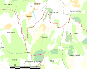
Accolans (Accolans)

- commune in Doubs, France
 Hiking in Accolans
Accolans, located in the Bourgogne-Franche-Comté region of France, is a quaint village known for its beautiful landscapes and natural surroundings. While it may not be as widely recognized as some other hiking destinations, it offers a serene environment for those looking to enjoy the outdoors.
Hiking Trails:
-
Local Trails: Accolans is surrounded by various rural and forested areas, which provide several local hiking paths. These trails often meander through picturesque meadows, woods, and hills, allowing hikers to experience Europe’s beautiful flora and fauna.
-
Nearby Natural Parks: Within a short drive, you can access larger natural parks, such as the Parc Naturel Régional du Haut-Jura, which has well-marked trails ranging from easy walks to more strenuous hikes.
Suggested Hiking Routes:
- Forest Trails: Look for trails that lead you through the nearby forests; these can be relatively flat and great for beginners or families.
- Cultural Routes: Some hikes may lead to local historical sites or viewpoints where you can take in the stunning views of the region’s vineyards or countryside.
Preparation:
- Footwear: Ensure you wear sturdy hiking boots suited for uneven terrain.
- Weather Considerations: The weather can change quickly, so check forecasts and be prepared with layers and waterproof gear.
- Navigation: Carry a map or GPS device, especially if you're venturing onto less-frequented trails.
Wildlife:
While hiking around Accolans, keep an eye out for local wildlife, including various bird species, deer, and other small animals.
Tips:
- Stay Hydrated: Bring enough water and possibly snacks for your hike, especially for longer treks.
- Respect Nature: Be mindful of the environment. Stick to marked trails, and avoid disturbing wildlife.
Local Attractions:
After a day of hiking, you might want to explore the village itself, which would typically include local cuisine and perhaps some wine tasting, given the regional agricultural prominence.
Conclusion:
Hiking around Accolans can be a charming experience with its combination of natural beauty and cultural heritage. Whether you're an experienced hiker or a casual walker, the area offers something for everyone. Just be sure to plan ahead and respect the area's natural beauty!
- Country:

- Postal Code: 25250
- Coordinates: 47° 29' 40" N, 6° 31' 55" E


- GPS tracks (wikiloc): [Link]
- Area: 5.18 sq km
- Population: 100
- Web site: http://www.accolans.fr/
- Wikipedia en: wiki(en)
- Wikipedia: wiki(fr)
- Wikidata storage: Wikidata: Q339327
- Wikipedia Commons Category: [Link]
- Freebase ID: [/m/03mgb9m]
- Freebase ID: [/m/03mgb9m]
- GeoNames ID: Alt: [6613147]
- GeoNames ID: Alt: [6613147]
- SIREN number: [212500052]
- SIREN number: [212500052]
- BnF ID: [15252231j]
- BnF ID: [15252231j]
- Twitter username: Alt: [Accolans]
- Twitter username: Alt: [Accolans]
- INSEE municipality code: 25005
- INSEE municipality code: 25005
Shares border with regions:


Soye
- commune in Doubs, France
Hiking in Soye
Hiking in Soye can be a wonderful experience for outdoor enthusiasts. While Soye may not be as widely known as other hiking destinations, it typically offers beautiful natural landscapes, varying terrain, and trails suitable for different skill levels....
- Country:
- Postal Code: 25250
- Coordinates: 47° 26' 41" N, 6° 29' 54" E
- GPS tracks (wikiloc): [Link]
- Area: 13.89 sq km
- Population: 385

Bournois
- commune in Doubs, France
Hiking in Bournois
Bournois is a charming area in France known for its natural beauty and scenic landscapes, making it a great destination for hiking enthusiasts. While specific trails might not be widely publicized, there are typically a variety of routes that cater to different skill levels, ranging from easy walks to more challenging hikes....
- Country:
- Postal Code: 25250
- Coordinates: 47° 29' 55" N, 6° 29' 49" E
- GPS tracks (wikiloc): [Link]
- Area: 10.48 sq km
- Population: 193

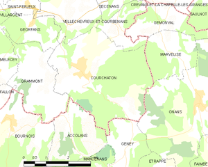
Courchaton
- commune in Haute-Saône, France
Hiking in Courchaton
As of my last knowledge update in October 2023, Courchaton doesn't appear to be a widely recognized hiking destination, so I may need more specific information on its location or features. However, if you are seeking hiking opportunities in lesser-known areas, there are a few general tips and considerations....
- Country:
- Postal Code: 70110
- Coordinates: 47° 30' 59" N, 6° 32' 25" E
- GPS tracks (wikiloc): [Link]
- Area: 13.53 sq km
- Population: 452


Geney
- commune in Doubs, France
Hiking in Geney
It seems like there might be a small typo in your request for information on hiking in "Geney." If you meant Geneva, which is renowned for its proximity to beautiful hiking trails in the surrounding mountains, specifically the Jura and the Alps, I’d be happy to help with that!...
- Country:
- Postal Code: 25250
- Coordinates: 47° 29' 9" N, 6° 34' 0" E
- GPS tracks (wikiloc): [Link]
- Area: 4.33 sq km
- Population: 131


Mancenans
- commune in Doubs, France
Hiking in Mancenans
Mancenans is a small commune located in the Doubs department in the Bourgogne-Franche-Comté region of eastern France. While it may not be as widely known as some larger hiking destinations, Mancenans and its surrounding areas offer beautiful landscapes and opportunities for outdoor activities, including hiking....
- Country:
- Postal Code: 25250
- Coordinates: 47° 27' 15" N, 6° 32' 34" E
- GPS tracks (wikiloc): [Link]
- AboveSeaLevel: 756 м m
- Area: 11.94 sq km
- Population: 317

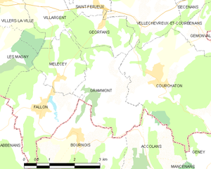
Grammont
- commune in Haute-Saône, France
Hiking in Grammont
Grammont, located in the Haute-Saône department in the region of Bourgogne-Franche-Comté, offers a variety of hiking opportunities that showcase the beautiful natural landscapes and rich cultural heritage of the area....
- Country:
- Postal Code: 70110
- Coordinates: 47° 30' 53" N, 6° 30' 59" E
- GPS tracks (wikiloc): [Link]
- Area: 5.94 sq km
- Population: 62