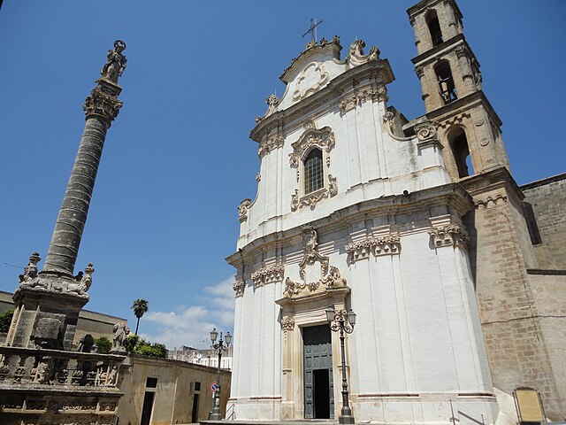
Acquarica del Capo (Acquarica del Capo)
.svg)
- Italian comune
 Hiking in Acquarica del Capo
Acquarica del Capo, located in the province of Lecce in the Apulia region of Italy, offers a unique hiking experience characterized by its stunning landscapes, rich history, and cultural heritage. Although it is a small town, there are various trails and natural areas nearby that can enhance your hiking adventure.
Trails and Natural Areas
-
Salento Region: Acquarica del Capo is situated in the Salento region, known for its picturesque countryside, olive groves, and beautiful coastline. Trails in the surrounding area can lead you through traditional stone walls, ancient farms, and vineyards.
-
Cave of the Palombaro: Close to Acquarica del Capo, this natural cave offers a short hike and a great opportunity to explore the unique geological formations in the area.
-
Coastal Paths: The coastline south of Acquarica del Capo features walking paths that provide breathtaking views of the Adriatic Sea. You can hike along the cliffs and enjoy the beach areas at nearby towns like Pescoluse and Torre Vado.
-
Natural Parks: Consider exploring the nearby Natural Park of Ugento, which has several marked trails that offer a mix of coastal and inland hiking, allowing you to appreciate both the flora and fauna of the region.
Hiking Tips
-
Best Time to Hike: The ideal times for hiking in this region are during the spring (April to June) and fall (September to October) when temperatures are mild, and the scenery is vibrant.
-
Prepare Accordingly: Wear good hiking shoes, carry enough water, and consider bringing snacks. The weather can change, so dress in layers and take sun protection, especially in the summer months.
-
Navigation: While many trails are well-marked, it’s always a good idea to have a map or a GPS device. Some areas may not be well-signposted.
-
Respect Nature: Follow the Leave No Trace principles to preserve the natural beauty of the trails and surrounding environments.
Acquarica del Capo and its surroundings provide a fantastic opportunity for hikers looking to explore scenic landscapes, experience regional culture, and enjoy the tranquility of the Italian countryside. Whether you are a novice hiker or an experienced trekker, this area has something to offer everyone.
- Country:

- Postal Code: 73040
- Local Dialing Code: 0833
- Licence Plate Code: LE
- Coordinates: 39° 55' 0" N, 18° 15' 0" E


- GPS tracks (wikiloc): [Link]
- AboveSeaLevel: 110 м m
- Area: 18.7 sq km
- Population: 4653
- Web site: http://www.comune.acquaricadelcapo.le.it/
- Wikipedia en: wiki(en)
- Wikipedia: wiki(it)
- Wikidata storage: Wikidata: Q52108
- Wikipedia Commons Category: [Link]
- Freebase ID: [/m/0fzymk]
- GeoNames ID: Alt: [6540754]
- VIAF ID: Alt: [241696993]
- OSM relation ID: [40146]
- TGN ID: [7056684]
- ISTAT ID: 075001
- Italian cadastre code: A042
Shares border with regions:
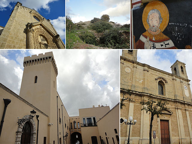
Presicce
- Italian comune
Hiking in Presicce
Presicce is a charming town located in the Salento region of Puglia, Italy. While it might not be the first location that comes to mind when you think of hiking, the surrounding areas offer some lovely opportunities for outdoor exploration....
- Country:
- Postal Code: 73054
- Local Dialing Code: 0833
- Licence Plate Code: LE
- Coordinates: 39° 54' 0" N, 18° 16' 0" E
- GPS tracks (wikiloc): [Link]
- AboveSeaLevel: 104 м m
- Area: 24.36 sq km
- Population: 5285
- Web site: [Link]


Ruffano
- Italian comune
Hiking in Ruffano
Ruffano is a charming town located in the Apulia region of Italy, known for its beautiful countryside, historical architecture, and warm climate. While Ruffano itself is not a major hiking destination, it is surrounded by stunning natural landscapes offering various hiking opportunities....
- Country:
- Postal Code: 73049
- Local Dialing Code: 0833
- Licence Plate Code: LE
- Coordinates: 39° 59' 0" N, 18° 15' 0" E
- GPS tracks (wikiloc): [Link]
- AboveSeaLevel: 127 м m
- Area: 39.73 sq km
- Population: 9741
- Web site: [Link]

Specchia
- Italian comune
Hiking in Specchia
Specchia is a charming town located in the Salento region of Puglia, Italy. While it is not as well-known for hiking as some other regions, it offers a variety of scenic walking paths and trails that can provide a delightful experience for hikers, particularly those who appreciate rural landscapes, historic architecture, and local culture....
- Country:
- Postal Code: 73040
- Local Dialing Code: 0833
- Licence Plate Code: LE
- Coordinates: 39° 56' 17" N, 18° 17' 54" E
- GPS tracks (wikiloc): [Link]
- AboveSeaLevel: 131 м m
- Area: 25.1 sq km
- Population: 4748
- Web site: [Link]
Taurisano
- Italian comune
Hiking in Taurisano
Taurisano, located in the Apulia region of Italy, is not typically known as a hiking destination, but it offers beautiful countryside, charming landscapes, and opportunities for exploration. Here are some insights to consider if you're thinking about hiking in this area:...
- Country:
- Postal Code: 73056
- Local Dialing Code: 0833
- Licence Plate Code: LE
- Coordinates: 39° 57' 0" N, 18° 10' 0" E
- GPS tracks (wikiloc): [Link]
- AboveSeaLevel: 110 м m
- Area: 23.68 sq km
- Population: 11770
- Web site: [Link]


Ugento
- Italian comune
Hiking in Ugento
Ugento, located in the Apulia region of Italy, is known for its beautiful landscapes, rich history, and stunning coastal areas. Hiking in and around Ugento offers a unique blend of natural beauty and cultural experiences. Here are a few highlights to consider when planning a hiking trip in Ugento:...
- Country:
- Postal Code: 73059
- Local Dialing Code: 0833
- Licence Plate Code: LE
- Coordinates: 39° 56' 0" N, 18° 10' 0" E
- GPS tracks (wikiloc): [Link]
- AboveSeaLevel: 108 м m
- Area: 100.4 sq km
- Population: 12412
- Web site: [Link]