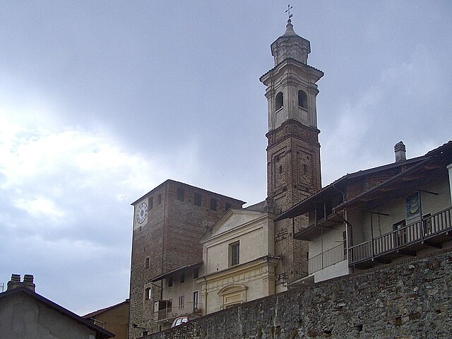
Agliè (Agliè)

- Italian comune
 Hiking in Agliè
Agliè, a charming town located in the Piedmont region of Italy, offers various opportunities for hiking enthusiasts. Nestled in the foothills of the Alps, Agliè is surrounded by beautiful landscapes, historical sites, and nature.
Hiking Spots
-
Parco del Castello di Agliè: The park surrounding the historic Agliè Castle offers pleasant trails for hiking. Visitors can enjoy well-maintained paths with serene views of the gardens and surrounding countryside.
-
Sentiero del Cuore: This trail leads through the picturesque countryside, providing captivating views of nearby hills and rural landscapes. It's a relatively easy hike suitable for families.
-
Natural Reserves: There are natural reserves and woodland areas around Agliè where you can explore nature trails. The area is known for its rich flora and fauna, making it a great spot for birdwatching and enjoying the local wildlife.
Tips for Hiking in Agliè
- Trail Difficulty: Assess your hiking experience and choose trails that match your skill level. Some paths can be steep or rugged.
- Weather Awareness: Check the weather before heading out. Spring and fall offer mild climates, while summers can get warm.
- Gear: Wear proper hiking boots for comfort and support. Bringing a backpack with water, snacks, a map, and a first-aid kit is advisable.
- Respect Nature: Stick to marked trails, and be mindful of the environment. Carry out any trash and respect local wildlife.
Nearby Attractions
After your hike, consider exploring the historical sites in Agliè, such as the Agliè Castle, or visit local wineries to experience Piedmont's renowned wine culture.
Overall, hiking in Agliè allows you to enjoy the natural beauty and cultural heritage of the region while offering trails suitable for various levels of experience. Whether you're looking for a casual stroll through historical gardens or a more challenging trail in the hills, Agliè has something to offer.
- Country:

- Postal Code: 10011
- Local Dialing Code: 0124
- Licence Plate Code: TO
- Coordinates: 45° 22' 0" N, 7° 46' 0" E


- GPS tracks (wikiloc): [Link]
- AboveSeaLevel: 315 м m
- Area: 13.15 sq km
- Population: 2646
- Web site: http://www.comune.aglie.to.it/
- Wikipedia en: wiki(en)
- Wikipedia: wiki(it)
- Wikidata storage: Wikidata: Q8971
- Wikipedia Commons Gallery: [Link]
- Wikipedia Commons Category: [Link]
- Freebase ID: [/m/0g348m]
- GeoNames ID: Alt: [6537004]
- VIAF ID: Alt: [137653013]
- OSM relation ID: [44808]
- TGN ID: [7005689]
- UN/LOCODE: [ITAGI]
- ISTAT ID: 001001
- Italian cadastre code: A074
Shares border with regions:


San Giorgio Canavese
- Italian comune
Hiking in San Giorgio Canavese
San Giorgio Canavese is a beautiful town located in the Piedmont region of northern Italy, nestled in the Canavese area, which is known for its stunning landscapes, hills, and valleys. The region offers a range of hiking opportunities that cater to various skill levels, from easy strolls to more challenging hikes....
- Country:
- Postal Code: 10090
- Local Dialing Code: 0124
- Licence Plate Code: TO
- Coordinates: 45° 20' 0" N, 7° 48' 0" E
- GPS tracks (wikiloc): [Link]
- AboveSeaLevel: 300 м m
- Area: 20.41 sq km
- Population: 2570
- Web site: [Link]


San Martino Canavese
- Italian comune
Hiking in San Martino Canavese
San Martino Canavese is a charming village located in the Canavese region of Piedmont, Italy. It offers a variety of hiking opportunities that cater to different skill levels and provide stunning views of the surrounding landscape, including the Alps and lush valleys....
- Country:
- Postal Code: 10010
- Local Dialing Code: 0125
- Licence Plate Code: TO
- Coordinates: 45° 24' 0" N, 7° 49' 0" E
- GPS tracks (wikiloc): [Link]
- AboveSeaLevel: 385 м m
- Area: 9.79 sq km
- Population: 826
- Web site: [Link]


Torre Canavese
- Italian comune
Hiking in Torre Canavese
Torre Canavese is a charming town located in the Canavese region of the Piedmont area in northern Italy. The region is characterized by its beautiful landscapes, rolling hills, and the nearby foothills of the Alps, making it an excellent destination for hiking enthusiasts....
- Country:
- Postal Code: 10010
- Local Dialing Code: 0124
- Licence Plate Code: TO
- Coordinates: 45° 23' 0" N, 7° 46' 0" E
- GPS tracks (wikiloc): [Link]
- AboveSeaLevel: 417 м m
- Area: 5.45 sq km
- Population: 594
- Web site: [Link]


Vialfrè
- Italian comune
Hiking in Vialfrè
Vialfrè is a small town in the Province of Turin, in the Piedmont region of Italy. It's an idyllic spot for hikers looking to explore natural beauty and enjoy the serene landscapes of the surrounding area. Here are some highlights and tips for hiking around Vialfrè:...
- Country:
- Postal Code: 10090
- Local Dialing Code: 0125
- Licence Plate Code: TO
- Coordinates: 45° 23' 0" N, 7° 49' 0" E
- GPS tracks (wikiloc): [Link]
- AboveSeaLevel: 470 м m
- Area: 4.65 sq km
- Population: 252
- Web site: [Link]

Bairo
- Italian comune
Hiking in Bairo
Hiking in Bairo, a region known for its stunning landscapes and natural beauty, can be a rewarding experience. While information on Bairo might vary depending on the specific location you’re referring to (there are several places with similar names), I can give you general tips and trails you might find in typical hiking areas....
- Country:
- Postal Code: 10010
- Local Dialing Code: 0124
- Licence Plate Code: TO
- Coordinates: 45° 23' 9" N, 7° 45' 2" E
- GPS tracks (wikiloc): [Link]
- AboveSeaLevel: 360 м m
- Area: 7.09 sq km
- Population: 802
- Web site: [Link]


Cuceglio
- Italian comune
Hiking in Cuceglio
Cuceglio is a small village located in the Piedmont region of Italy, nestled in the foothills of the Alps. This area is known for its stunning natural landscapes, including rolling hills, lush forests, and picturesque views of the surrounding mountains. Hiking in and around Cuceglio can be an excellent way to experience the region's beauty and tranquility....
- Country:
- Postal Code: 10090
- Local Dialing Code: 0124
- Licence Plate Code: TO
- Coordinates: 45° 22' 0" N, 7° 49' 0" E
- GPS tracks (wikiloc): [Link]
- AboveSeaLevel: 375 м m
- Area: 6.87 sq km
- Population: 998
- Web site: [Link]


Ozegna
- Italian comune
Hiking in Ozegna
Ozegna is a charming town located in the Piedmont region of Italy, nestled between the Susa and Orco Valleys. The surrounding area offers beautiful trails that are suitable for both beginners and more experienced hikers. Here are some key points about hiking in and around Ozegna:...
- Country:
- Postal Code: 10080
- Local Dialing Code: 0124
- Licence Plate Code: TO
- Coordinates: 45° 21' 0" N, 7° 45' 0" E
- GPS tracks (wikiloc): [Link]
- Area: 5.41 sq km
- Population: 1225
- Web site: [Link]