Airola (Airola)
.svg)
- Italian comune
 Hiking in Airola
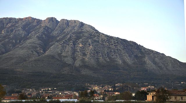
Airola is a charming town located in the Campania region of Italy, offering a variety of hiking opportunities in its surrounding areas. Nestled in the hills near the Vesuvius National Park and the beautiful landscapes of the Sannio region, Airola serves as a good starting point for exploring nature and enjoying outdoor activities.
Hiking Trails
- Regional Parks: You can explore trails within the nearby regions, such as Vesuvius National Park, which features stunning views of the volcano and surrounding areas.
- Sannio Region: This region is known for its picturesque hills and valleys, where you can find trails that vary in difficulty, suitable for both beginners and experienced hikers.
- Local Trails: There are also various local paths and trails around Airola itself, offering opportunities to discover the rich flora and fauna of the area, as well as historical sites.
Hiking Tips
- Check Local Maps: Before heading out, ensure you have updated maps or GPS devices, as some trails may be less marked.
- Weather Preparedness: The weather can change, so dress in layers and carry rain gear.
- Footwear: Wear appropriate hiking boots to navigate the often rugged terrain comfortably.
- Hydration: Bring plenty of water, especially during warmer months, as some trails may lack easy access to water sources.
Safety Considerations
- Wildlife Awareness: Be aware of local wildlife and practice safety around any animals you may encounter.
- Group Hikes: If you’re unfamiliar with the area, consider hiking with a group or hiring a local guide to enhance your experience.
Cultural Aspects
In addition to exploring nature, hiking in and around Airola allows you to experience local culture, cuisine, and hospitality. After a day of hiking, be sure to enjoy local dishes at nearby trattorias.
Overall, hiking in Airola provides a wonderful mix of natural beauty, cultural experiences, and outdoor recreation. Enjoy your adventure!
- Country:

- Postal Code: 82011
- Local Dialing Code: 0823
- Licence Plate Code: BN
- Coordinates: 41° 3' 31" N, 14° 33' 33" E


- GPS tracks (wikiloc): [Link]
- AboveSeaLevel: 270 м m
- Area: 14.9 sq km
- Population: 8390
- Web site: http://www.comune.airola.bn.it/
- Wikipedia en: wiki(en)
- Wikipedia: wiki(it)
- Wikidata storage: Wikidata: Q55798
- Wikipedia Commons Category: [Link]
- Freebase ID: [/m/0gn0t_]
- GeoNames ID: Alt: [6537314]
- VIAF ID: Alt: [128739196]
- OSM relation ID: [41060]
- UN/LOCODE: [ITZCG]
- ISTAT ID: 062001
- Italian cadastre code: A110
Shares border with regions:
Rotondi
- Italian comune
Hiking in Rotondi
Rotondi is a charming town located in the Campania region of southern Italy, surrounded by beautiful landscapes that are ideal for hiking enthusiasts. The area offers a mix of cultural and natural attractions, with scenic trails that showcase the local flora and fauna, as well as stunning views of the surrounding countryside....
- Country:
- Postal Code: 83017
- Local Dialing Code: 0824
- Licence Plate Code: AV
- Coordinates: 41° 1' 57" N, 14° 35' 45" E
- GPS tracks (wikiloc): [Link]
- AboveSeaLevel: 272 м m
- Area: 7.81 sq km
- Population: 3654
- Web site: [Link]


Arpaia
- Italian comune
Hiking in Arpaia
Arpaia, located in the Campania region of Italy, is not typically known as a major hiking destination compared to more famous locales like the Dolomites or the Amalfi Coast. However, it offers opportunities for exploring the beautiful Apennine Mountains and the surrounding nature....
- Country:
- Postal Code: 82012
- Local Dialing Code: 0823
- Licence Plate Code: BN
- Coordinates: 41° 2' 0" N, 14° 33' 0" E
- GPS tracks (wikiloc): [Link]
- AboveSeaLevel: 283 м m
- Area: 4.96 sq km
- Population: 2046
- Web site: [Link]

Bonea
- Italian comune
Hiking in Bonea
Bonea is a beautiful area for hiking, often characterized by its stunning landscapes, diverse ecosystems, and rich cultural heritage. To give you an idea of what to expect, here's a breakdown of what hiking in Bonea might offer:...
- Country:
- Postal Code: 82013
- Local Dialing Code: 0824
- Licence Plate Code: BN
- Coordinates: 41° 4' 0" N, 14° 37' 0" E
- GPS tracks (wikiloc): [Link]
- AboveSeaLevel: 350 м m
- Area: 11.46 sq km
- Population: 1415
- Web site: [Link]


Bucciano
- Italian comune
Hiking in Bucciano
Bucciano, a small village in the province of Benevento in Italy, offers a unique charm and beautiful landscapes for hikers. Nestled in the rolling hills of Campania, it’s surrounded by lush greenery and provides an authentic Italian rural experience....
- Country:
- Postal Code: 82010
- Local Dialing Code: 0823
- Licence Plate Code: BN
- Coordinates: 41° 4' 39" N, 14° 34' 8" E
- GPS tracks (wikiloc): [Link]
- AboveSeaLevel: 276 м m
- Area: 7.94 sq km
- Population: 2098
- Web site: [Link]


Forchia
- Italian comune
Hiking in Forchia
Forchia is a charming town located in the Campania region of Italy, situated near the southern slopes of the Apennine Mountains. While it may not be as famous as some other hiking destinations in Italy, it offers a unique opportunity to explore the beautiful landscapes and rural charm of the region....
- Country:
- Postal Code: 82011
- Local Dialing Code: 0823
- Licence Plate Code: BN
- Coordinates: 41° 1' 53" N, 14° 32' 9" E
- GPS tracks (wikiloc): [Link]
- AboveSeaLevel: 282 м m
- Area: 5.45 sq km
- Population: 1221
- Web site: [Link]


Moiano
- Italian comune
Hiking in Moiano
Moiano is a charming village located in the Campania region of Italy, surrounded by picturesque landscapes that offer numerous hiking opportunities. Here are some key points to consider when planning a hike in and around Moiano:...
- Country:
- Postal Code: 82010
- Local Dialing Code: 0823
- Licence Plate Code: BN
- Coordinates: 41° 5' 0" N, 14° 33' 0" E
- GPS tracks (wikiloc): [Link]
- AboveSeaLevel: 271 м m
- Area: 20.2 sq km
- Population: 4099
- Web site: [Link]


Paolisi
- Italian comune
Hiking in Paolisi
Paolisi, a picturesque village located in the Campania region of Italy, offers some charming hiking opportunities for both locals and visitors. Nestled in the foothills of the Apennines, the area surrounding Paolisi is characterized by rolling hills, lush vegetation, and scenic views, making it a great destination for outdoor enthusiasts....
- Country:
- Postal Code: 82011
- Local Dialing Code: 0823
- Licence Plate Code: BN
- Coordinates: 41° 2' 0" N, 14° 35' 0" E
- GPS tracks (wikiloc): [Link]
- AboveSeaLevel: 270 м m
- Area: 6 sq km
- Population: 2104
- Web site: [Link]